Drought Monitoring and Prediction in South Asia
Contributed by: Vimal Mishra* and Saran Aadhar, Civil Engineering, Indian Institute of Technology (IIT) Gandhinagar, India
Drought is one of the most complex natural disasters. In South Asia — a region including India, Pakistan, Bangladesh, Sri Lanka, Nepal, and Bhutan — increasing population, dependence on agriculture, and frequent droughts have resulted in water scarcity and food scarcity. In India, for example, about 330 million people were affected by the 2014-15 droughts, which led to severe water shortages (Mishra et al., 2016). Some of the detrimental impacts of droughts can be mitigated by proactive planning, including the monitoring and prediction of drought conditions. Real-time monitoring of drought conditions involves assessing the conditions of precipitation, evapotranspiration, soil moisture, runoff, and vegetation health. Providing information on the intensity and spatial extent of drought, and identification and prediction of onset and development of droughts can assist in proactive planning and decision-making by administrators, water managers, and farmers.
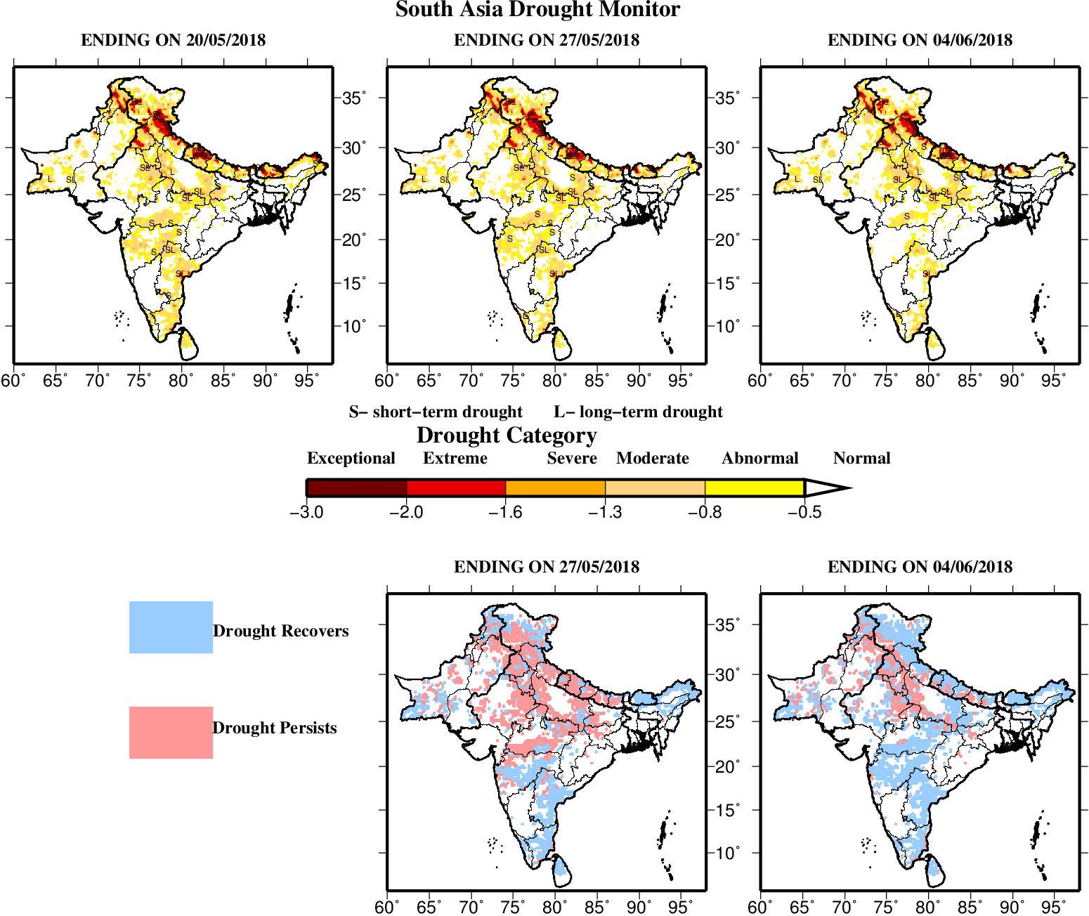
We have recently developed an ensemble-based drought monitoring and prediction system for South Asia, extending a prior Experimental Drought Monitor (Shah & Mishra, 2015) that was developed for India. The South Asia Drought Monitoring and Prediction System (Aadhar & Mishra, 2017) provides daily short-term forecasts (out to 15 days lead time) of precipitation, soil moisture, and runoff conditions, as well as associated drought indices: the standardized precipitation index (SPI), standardized soil moisture index (SSI) and standardized runoff index (SRI) reflecting meteorological, hydrological, and agricultural drought, respectively. A website for the drought monitoring and prediction system in South Asia provides online, real-time information from the system (examples shown in Figure 1).

Figure 1 – Examples of real-time drought products depicting conditions on 20th May 2018 and 7 and 15 day lead drought prediction in South Asia. Lower panels highlight the associated outcomes in terms of regions of drought persistence and recovery. More information can be obtained online (see South Asia Drought Monitor link below).
Drought Monitoring and Prediction System Components
The South Asia Drought Monitor uses retrospective daily precipitation data at 0.25 degree spatial resolution for the period of 1951-2007 from APHRODITE (Yatagai et al, 2012), which was developed for the Asian monsoon region using observation stations from different countries. For daily real-time precipitation forcing, the Tropical Rainfall Measurement Mission (TRMM) 3B42RT v7 precipitation data were used. Retrospective daily maximum and minimum temperature were obtained, also at 0.25 degree, from the Princeton University meteorological global dataset (Sheffield et al, 2006). Observed temperature data are not available in near-real time; therefore, we used daily maximum and minimum temperatures from the Global Ensemble Forecast System (GEFS) from 2006 onwards.
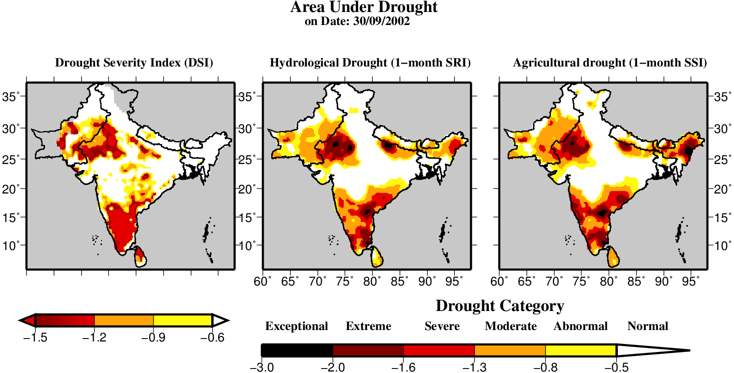
Meteorology from both TRMM and GEFS data were bias-corrected and applied to drive VIC model simulations from 1951 to the present, and through the forecast period. Validation of the drought monitoring and forecast products has also been conducted. For example, we compare the VIC model simulated (SSI and SRI) drought results with the Drought Severity Index (DSI). The DSI is the remotely sensed drought extent which is based on vegetation health, calculated using MODIS ET/PET and NDVI data for the vegetated land surface at 8-day, monthly, and yearly intervals. Figure 2 shows the VIC model simulated areal extents of drought for the 2002 monsoon season case, which revealed similar drought extents to those obtained from DSI estimates.

Figure 2 – Comparison of drought indices from the VIC model simulation (drought monitor) with the DSI for the monsoon season drought in the year 2002. The area under the drought was estimated using DSI (Left), SRI (Middle), and SSI (Right).
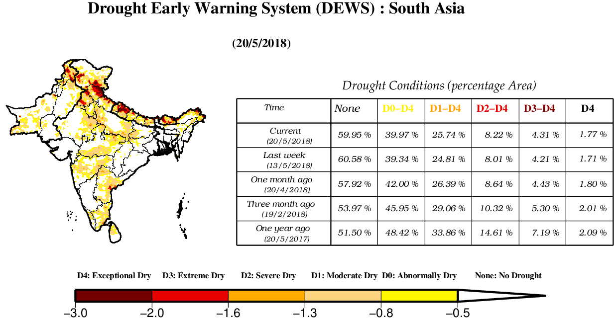
Real-time meteorological forecasts from the Global Ensemble Forecast System (GEFS) reforecast were used to drive the medium range (7 to 15 –days) drought and downscaled precipitation forecast in South Asia. The GEFS reforecast is available at the spatial resolution of 1 degree at every 3-hour temporal resolution for 0 to 72 hours and 6-hour temporal resolution for 72 to 384 hours. We regridded the 1-degree daily precipitation, maximum (Tmax) and minimum (Tmin) temperatures to 0.25 degree. The GEFS reforecasts of precipitation and air temperatures data were used to forecast the hydrological variables (soil moisture and runoff) using the VIC model simulation. Shah et al. (2016; 2017) describe the skill of the soil moisture and runoff drought indices over India based on the GEFS forecast data. Currently, the South Asia Drought Monitoring and Prediction System also provides information in a form that supports a drought early warning system (DEWS), which compares current drought conditions with past (1-week, 1-month, 3-month, and 1-year) drought conditions for every South Asian country (Figure 3).

Figure 3 – Drought early warning system (DEWS) products for 20th May 2018 for South Asia, including the area (%) under drought of different severity categories. More information can be obtained online (see links below).
Comments, questions and feedback on the effort are welcome!
Contact: Vimal Mishra — email vmishra@iitgn.ac.in or Twitter @vmishraiit
References
Aadhar, S., & Mishra, V. (2017). High-resolution near real-time drought monitoring in South Asia. Scientific Data, 4, 170145. Retrieved from http://dx.doi.org/10.1038/sdata.2017.145
Mishra, V., Aadhar, S., Asoka, A., Pai, S., & Kumar, R. (2016). On the frequency of the 2015 monsoon season drought in the Indo-Gangetic Plain. Geophysical Research Letters, 43(23), 12,102-12,112. https://doi.org/10.1002/2016GL071407
Shah, R., Sahai, A. K., & Mishra, V. (2016). Short-to-medium range hydrologic forecast to manage water and agricultural resources in India. Hydrology and Earth System Sciences Discussions, (October), 1–23. https://doi.org/10.5194/hess-2016-504
Shah, R., Sahai, A. K., & Mishra, V. (2017). Short to sub-seasonal hydrologic forecast to manage water and agricultural resources in India. Hydrology and Earth System Sciences, 21(2), 707–720. https://doi.org/10.5194/hess-21-707-2017
Shah, R. D., & Mishra, V. (2015). Development of an Experimental Near-Real-Time Drought Monitor for India. Journal of Hydrometeorology, 16(1), 327–345. https://doi.org/10.1175/JHM-D-14-0041.1
Sheffield, J., G. Goteti, and E. F. Wood, Development of a 50-yr high-resolution global dataset of meteorological forcings for land surface modeling, J. Climate, 19 (13), 3088-3111.
Yatagai, A., K. Kamiguchi, O. Arakawa, A. Hamada, N. Yasutomi, and A. Kitoh, 2012: APHRODITE: Constructing a Long-Term Daily Gridded Precipitation Dataset for Asia Based on a Dense Network of Rain Gauges. Bull. Amer. Meteor. Soc., 93, 1401–1415, https://doi.org/10.1175/BAMS-D-11-00122.1
Links:
November 5, 2018 at 23:04
Hi
You can use these tools for calculating of drought indices:
https://agrimetsoft.com/MDM.aspx
https://agrimetsoft.com/KBDIS.aspx
https://agrimetsoft.com/RDIT.aspx
https://agrimetsoft.com/drought%20monitor.aspx
Cheers