Hydrological forecasting – a challenge for Poland
Contributed by Renata Romanowicz
When one wants to learn about forecasting in Poland, clicking on Google would be the most obvious option.
However, there are many openings, each getting your key-word right, but there is not much to be learned. There are sites that tell you that they do on-line forecasting – it may be successful but the methods employed are a mystery! It is impossible to find any explanation as to how the forecasts are actually done.
After a long search through books and reports we found some information on the hydrological cover in Poland. Here is a short report on our findings.
A bit of history
The recent big floods in 1997 and 2010 promoted a discussion of the issue of flood forecasting. The 2010 year flood was one of the largest since the 19th century in Poland. The second flood wave followed the first only 10 days later, with high water levels along the middle and lower River Vistula reaches.
The flood alert system plays an important role in decreasing the flood risk. After the disastrous flood in 1997, the existing system of Hydrological Forecasting for the whole of Poland was upgraded and modernized as a component of the Emergency Flood Recovery Project, financed by the World Bank. It had the form of a System of Monitoring, Forecasting and Warning (SMOK), transformed later into the System of Hydrology (SH), developed in the Institute of Meteorology and Water Management (IMGW).
The operational hydrological models used for short-term flood forecasting include simplified models of flood wave transformation in the river channel and hydrodynamic models, such as MIKE 11 and IHMS HBV-HD. The 2001 and 2010 floods of the Vistula showed that ungauged tributaries played an important role in flood wave transformation along the river. This indicates that the meteorological forecast might be of major importance in predicting the evolution of a flood wave along the river.
How to introduce operational on-line flood forecasting in Poland?
Recently, a number of local-scale actions were undertaken to develop a flood warning system based on telecommunication (internet and mobile phones). However, not much was done in the development of new flood forecasting tools. One of the interesting new attempts in this area is the development of a system supporting a comparison of hydrologic predictions, HydroProg, which was initiated in Wroclaw University. The objective of the project is to develop a database of hydrological predictions computed by various scientific groups.
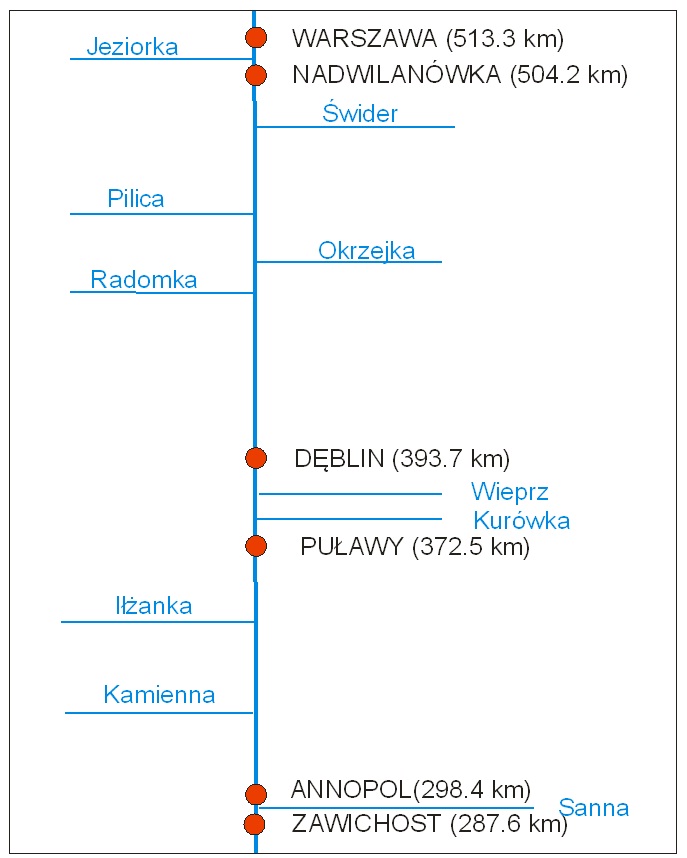
The research project “Stochastic flood forecasting system (The River Vistula reach from Zawichost to Warsaw)” carried out by order of the National Science Centre (contract No. 2011/01/B/ST10/06866) in the Institute of Geophysics Polish Academy of Sciences, Warsaw, is another example of the work on flood forecasting problems carried out in Poland. The aim of the project is the development of an integrated flood forecasting system for the middle reach of the River Vistula. The system includes the main river channel and its tributaries (Fig. 1).
Fig. 1: The scheme of the forecasting system for the River Vistula between Zawichost and Warsaw; red dots denote gauging stations (Romanowicz et al., 2014)
The novelty of the approach consists in the integration of a number of different hydrological modelling tools, including distributed, lumped-parameter, deterministic and stochastic models that are run in parallel. The rainfall-runoff models applied include the conceptual deterministic model HBV and the Data Based Mechanistic, Stochastic Transfer Function (STF) modelling approach (Young, 2001). The flow-routing models include MIKE11 and HEC-RAS, as well as STF water level models, and an STF-based distributed model simulator (Romanowicz et al., 2010).
The results show that predictions of water levels at Warsaw gauging stations can be obtained with three-to- five days lead time with an accuracy of up to 20 cm std. Apart from the water level estimates the prediction 0.95 confidence limits are also estimated.
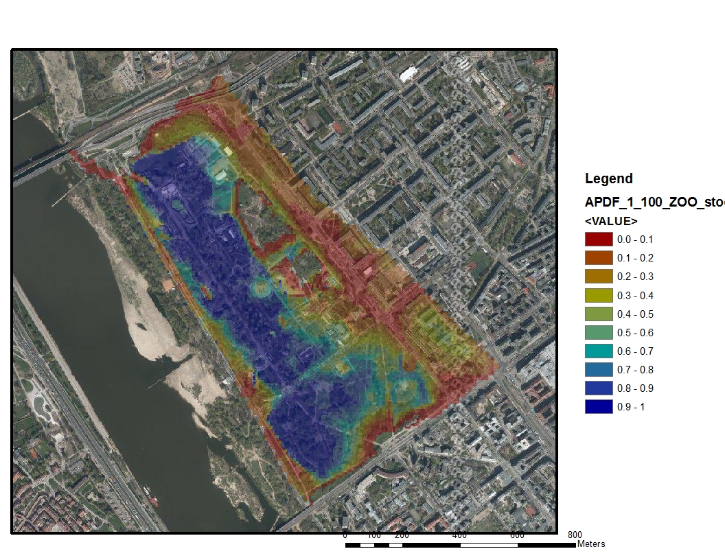
The application of distributed models enables probability maps of the inundation to be prepared for flood-prone areas. The scenario analysis study of breaching of river embankments in the vicinity of ZOO area in Warsaw (Fig. 2) was performed using the HEC-RAS model (Kiczko et al., 2013). The system will also be used in scenario analysis by its end-user, the Warsaw Regional Water Board (RZGW Warszawa).

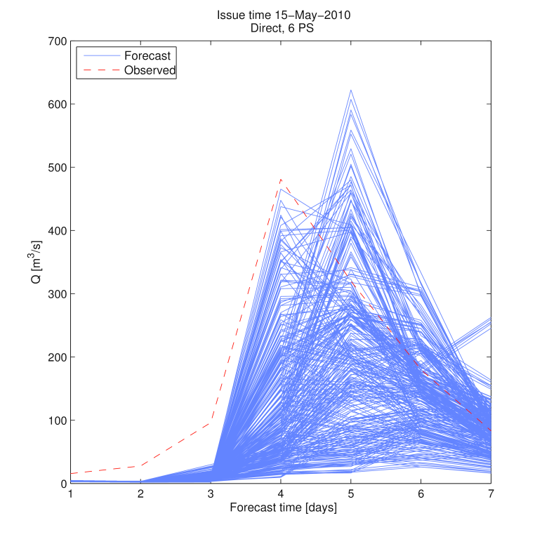
Another extension of the flood forecasting system presented consists of the application of the ECMWF forecasts (obtained from the project TIGGE) to prolong the lead time of the forecasts downstream, which is the subject of on-going work by the project team (Fig. 3)

The results of the project will be summarised as a book that will be issued by Springer in the GeoPlanet series next year under the title Stochastic Flood Forecasting System for the Middle River Vistula.
Therefore, we are looking to the future. There is still much to be done to make on-line forecasting in Poland a reality, but some progress has already been made.
References
- Kiczko, A., Romanowicz, R. J., Osuch, M., and Karamuz, E., 2013, Maximising the usefulness of flood risk assessment for the River Vistula in Warsaw, Nat. Hazards Earth Syst. Sci., 13, 3443-3455, doi:10.5194/nhess-13-3443-2013.
- Romanowicz, R.J., Kiczko, A. & Napiórkowski, J. J., 2010, Stochastic transfer function model applied to combined reservoir management and flow routing. Hydrological Sciences Journal, 55 (1), 27–40.
- Romanowicz, R.J., M. Osuch and E. Karamuz, 2014, Stochastic flood forecasting system for the River Vistula between Zawichost and Warsaw, II Polish Hydrological Congress, in Polish, in print.
- Young P.C., 2001, Data-based mechanistic modeling and validation of rainfall-flow processes. In: Model validation: perspectives in hydrological science (ed. M.G. Anderson and P.D. Bates), pp 117-161, Wiley.
by Renata Romanowicz, Institute of Geophysics, Polish Academy of Sciences, Poland, e-mail: romanowicz@igf.edu.pl

0 comments