Advancing impact-based early warning systems for riverine flooding
by Husain Najafi and co-authors of the Najafi et al. (2024)
“It is no longer enough to provide a good weather forecast or warning – people are now demanding information about what to do to ensure their safety and protect their property.” — WMO Guidelines on Multi-hazard Impact-based Forecast and Warning Services (WMO-No. 1150)
Traditional weather forecasts focus on predicting meteorological phenomena, such as rainfall amounts or storm intensity. While these forecasts are crucial, they often fall short in helping to understand the potential impacts on people’s lives and property. Impact-based forecasts and warnings, however, can bridge this gap by providing more actionable information for better contingency planning and disaster risk preparedness. As a result, many National Hydrological and Meteorological Services (NHMSs) are considering migrating from phenomenon-based to impact-based paradigms. These warnings can be tailored not only to sector-specific users but also to the general public when facing imminent hazards.
To support the transition to this new paradigm, validating high-resolution and impact-based warnings for significant events is essential. Our recent publication Najafi et al. (2024) in Nature Communications showcases an experimental impact-based flood early warning system, demonstrated by hindcasting the 2021 summer flood in Ahr, West Germany.
High-resolution weather predictions from the German Weather Service, DWD’s state-of-the-art ICON D2-EPS model are utilized for hydrological forecasting using the mesoscale Hydrologic Model (mHM; Kumar et al., 2013; Samaniego et al., 2010). Our study enhances the flood forecasting chain with rapid hydrodynamic modeling (RIM2D) to predict inundation areas. We also integrate digital mapping information from OpenStreetMap (OSM) to identify at-risk buildings, roads, and railways.
We provide time-dependent flood probabilities exceeding the 100-year flood threshold, updated every 3 hours, to support end-user decision-making. Additionally, we generate lead-time maps that consider forecast persistency as a tool for measures such as evacuation (see Figure below). Our results from the forecasting chain (ICON D2 EPS-mHM-RIM2D) were compared with Copernicus Emergency Management Service (CEMS) Rapid Mapping, demonstrating a high agreement between the predicted and observed damages by the authorities.
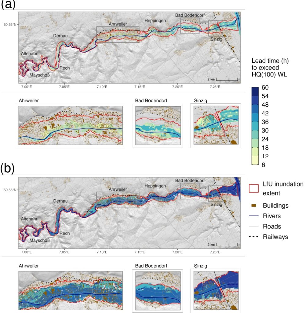
A maximum lead-time raster-based flood warning map is a geospatial representation that highlights the maximum available time for flood preparedness and response. The lead time is calculated downstream Altenahr gauge based on water levels (WL) exceeding 100-year flood. (a) The lead-time map derived from 16 ensemble median water levels (i.e., median over 20 members for each NWP initialisation). (b) The same but obtained with 16 maximum water levels. The red extent delineates the inundation area mapped by the LfU of Rhineland-Palatinate. Supplementary data sources: OSM river, roads and buildings: OpenStreetMap contributors 2021 distributed under the Open Data Commons Open Database License (ODbL) v1.0. Hillshade: DTM v0.3 (CC BY), adapted from Najafi et al. (2024).
Five different ensemble statistics (minimum, 25th, 50th, 75th, and maximum percentiles) are considered from a set of 20 ensemble members for inundation prediction and impact-based warning. These statistics help communicate the uncertainties propagating through the forecasting chain. However, we note that other ensemble statistics can be defined based on user-relevant terms during a co-designing procedure for informed decision-making.
We want to communicate the insights that the median forecast underestimated the flood inundation area compared to the flood mapping data provided by the Rhineland-Palatinate (RP) State Office for the Environment (LfU). This underestimation can be attributed to factors such as ensemble median precipitation forecasts being lower than observed quantitative estimations and the short time period available for hydrological model calibration. Therefore, we highlight the importance of applying bias corrections to atmospheric forecasts and recalibrating models following major events.
Although in our paper, we use a hindcast experiment to illustrate these issues, the insights gained can inform the development of effective operational impact warning services by NHMSs. In the next test phase beginning in summer 2024, the automated model chain will undergo real-time testing in the second phase of the Helmholtz Climate Initiative, focusing on two additional catchments in the Fils and Murr rivers in Baden-Württember.
Finally, we want to repeat and emphasize that transitioning to impact-based forecasting represents a significant advancement in disaster risk preparedness, enabling better protection of lives and property.
Enjoy reading our paper.
0 comments