Benefit achieved in the 2014 flood in Bangladesh
Contributed by S.H.M. Fakhruddin
It has long been recognized that if society could have information on floods in advance, the adverse effects associated with them could be minimized. Prevalence of traditional forecast practices in various parts of the world reflects the demand for long-range forecasts to manage uncertainties associated with climate variability. Recent advancements in long-lead flood prediction promise huge benefits to countries like Bangladesh.
The case of Bangladesh
Floods during the summer monsoon are a recurring event in Bangladesh due to excessive rainfall and discharge, mainly from the Ganges and the Brahmaputra, into the Bangladesh delta, as well as retardation of outflow into the Bay of Bengal from high sea levels. Forecast and warning information, hence, are vital for reducing potential human and economic losses due to floods.
The Regional Integrated Multi-Hazard Early Warning System (RIMES), in collaboration with “Strengthening Household Abilities to Responds to Development Opportunity” project, or SHOUHARDO-II of CARE Bangladesh and USAID, provided technical support to operationalize a 10-day flood forecast system in Bangladesh, a unique project of Flood Forecasting and Warning Centre (FFWC) of Bangladesh Water Development Board (BWDB).
The project titled “Climate Forecasting Applications for Bangladesh” initially started in 2000 funded by USAID, two years after the country experienced massive flooding in 1998, in order to provide longer lead time flood forecasts for Bangladesh. The CFAN project was successfully made possible by strong partnerships between Georgia Tech, FFWC of BWDB, RIMES, ECMWF, and many others. As a result of final ownership of the technologies residing in Bangladesh, the FFWC has proven their leadership in the region to operationalize an end-to-end early warning system in the region. The process of enhancing the flood forecasting scheme is shown below:

Figure 1: Evolving of long lead flood forecasting system in Bangladesh
The 2014 floods
The event is mainly characterized by flooding in the Brahmaputra basin. The peak flooding was recorded on 28th August 2014, when 19 stations all over the country were flowing over the danger level, and all the stations along the Brahmaputra-Jamuna and Padma were also flowing over danger levels. Maximum flooding was at Sariakandi of Bogra district, where the peak water level was 99 cm above danger level on 29th August. The duration of the flood was more or less 12 days, on average over different river stations in the Brahmaputra basin.
In the Ganges basin, the flooding was maximum at Goalondo point, where the Ganges was flowing 27 cm above danger level on 31st August 2014. Overall flooding in the Ganges basin was less prolonged and the duration varied from 8-10 days at different river stations.
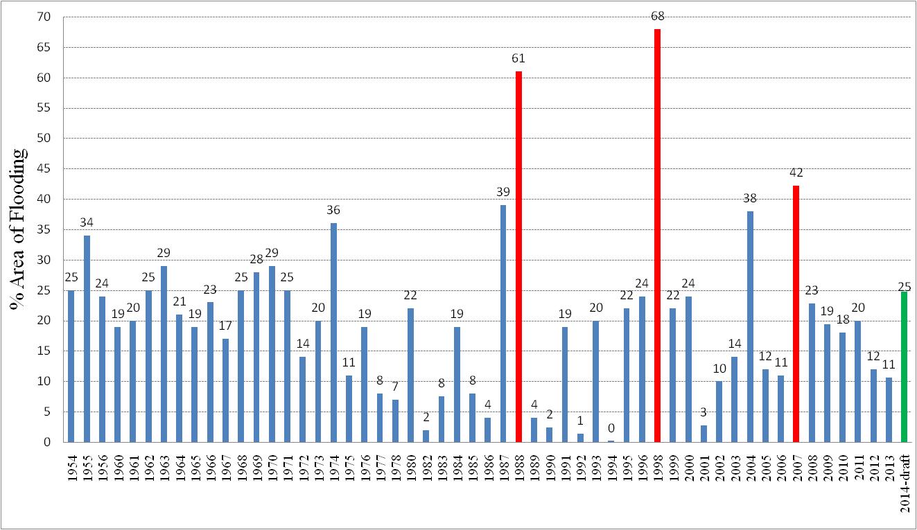
Flooding in 2014 was less severe than the flooding in 2012, but more severe than the floods in 2013, both in terms of duration and intensity. However, the area inundated (25% following a tentative calculation by FFWC) was the highest in the last seven years after flood 2007.
The flooding was less severe than the 2012 floods, and the water receded rapidly because there was no peak synchronization between the Jamuna and the Ganges rivers: when the Jamuna at Bahadurabad station reached the peak, the Ganges was already following a receding trend. The historical percentages of areas affected by floods are shown below:
Hydrological forecasts
For sophisticated hydrological forecasts, a large amount of data is needed. Initial data used for the development of hydrological inputs are from a number of sources (e.g., satellite driven Tropical Rainfall Measuring Mission – TRMM, Climate Prediction Centre morphing method – CMORPH, and European Centre for Medium range Weather Forecasts – ECMWF – EPS forecasts).
To run the hydrological model, hydrological streamflow data at the borders of the country, as well as satellite data and derived precipitation products from NASA and NOAA, are collected. This data is run through the database and distributed in hydrological modelling. A lumped and a semi-distributed hydrological model were used in the multi-model discharge forecasting.
The modelling technique employs multiple linear regressions of observed discharge, and observed and forecast precipitation, along with a nonlinear “effective rainfall” filter, based on the idea of linear storage reservoirs, and a model structure similar to Unit Hydrograph theory model. It provides discharge forecasts of 1–10 days at the Bahadurabad station on the Brahmaputra, Harding Bridge at Ganges and Bhairab Bazar at Megna Basin. The hydrological modelling is 51 sets of discharge forecasts at desired locations in the river basin.
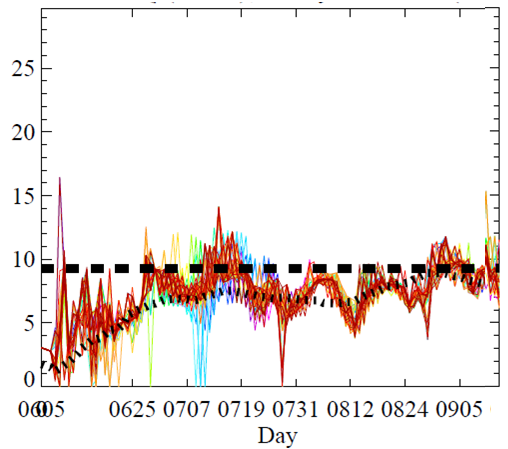
Discharge Forecasts Observed Q (black), 10-day Forecast (colors) in Megna Basin
The 10-day forecasts were generated and 51 sets of ensemble forecasts for a particular day at each discharge prediction point were obtained. The Figures on the left show 1-10 days flood forecasts at three major river locations for 2014. The bold black line denotes the observed flow matching the forecast dates, the horizontal dashed line denotes the river’s critical discharge level, and the distance between the plots’ right edge and the vertical line designates the forecasting interval. The 10-day forecasts are quite accurately, according to the root mean square error method.
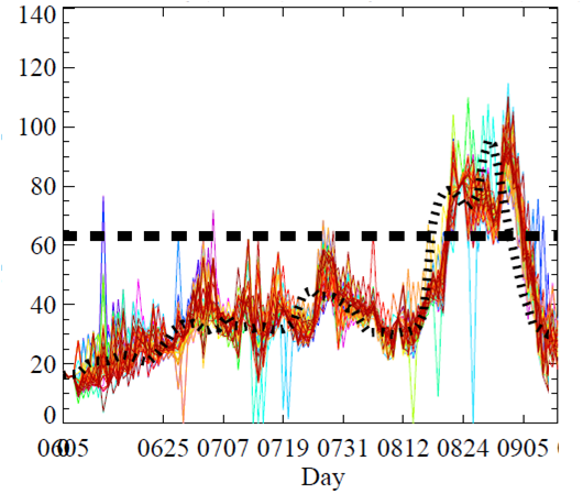
Discharge Forecasts Observed Q (black), 10-day Forecast (colors) in Ganges
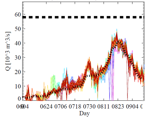
Discharge Forecasts Observed Q (black), 10-day Forecast (colors) in Brahmaputra
2014 Forecasts Applications and Benefits at the Community
Flood early warning was disseminated in the SHOUHARDO-II pilot areas (17 locations) through mobile SMS (in English 1-10 days forecast), emails (forecast outlook and bulletin both in Bangla and English) and the medium-range forecast was uploaded in the FFWC website. Two-way communication between RIMES-FFWC and regional staff of CARE-Bangladesh and LGIs was maintained from the advent of flood to ensure timely early warning.
After the dissemination of flood forecasts with potential chances of flooding, in most of the areas, the Union Disaster Management Committee (UDMC) members discussed the issue with high priority and started taking preparations to react and respond for flood defence. The disasters volunteers trained under SHOUHARDO-II played a vital role in disseminating the flood early warning in the community, especially in some remote areas for evacuation and save assets.
When rivers were about to flow above respective danger level, vulnerable populations were moved to safer places. It was reported that people saved their assets and properties like furniture, livestock, etc. Local people planned to store dry food and safe drinking water for about 15 days knowing that relief would start only 7 days after the initial flooding.
The community secured cattle, poultry birds, homestead vegetables, protected fishery by putting nets in advance, secured cooking stove, small vessels, firewood and animal dry fodder. They also planed to evacuate and identified high grounds with adequate sanitation and communication, and planed for alternative livelihood options immediately after flooding (eg., Small-scale fishing, boat making, etc.).
There was substantial damage of Transplanted-Aman (T-Aman) paddies since the standing crops were inundated for 10-12 days. However, people were able to re-utilize the seedbeds and planted the crops in the safe areas, based on 1-10 days forecasts. Loss of vegetable fields was reported from Kurigram, but farmers processing jutes used the forecast information to save their jutes under process from being washed away. In some areas with relatively less inundation, it was reported that people did not apply fertilizer to the field observing the rising trend of the water from the 10-day forecasts.
Apart from the direct benefit of the community, the early warning system has been reported to be very helpful to the government administrations and NGOs during the flood to assess the severity and the recession period for decision-making regarding response activities like relief distribution.
A more comprehensive assessment of the 2014 floods is undergoing to evaluate the economic benefits of the early warning system. Based on the 2007 and 2008 floods, an assessment was conducted and concluded that, approximately, US$40 was saved for every dollar invested in the flood forecasting and warning system. In the 2008 flood, the economic benefits, on average, per household at pilot areas, were:
- Livestock’s = TK. 33,000 ($485) per household;
- HH assets = TK. 18,500 ( $270) per household;
- Agriculture = TK 12,500 ($180) per household;
- Fisheries = TK. 8,800 ( $120) per households;
The usage of increased understanding of probabilistic long-lead flood forecasting is extremely valuable for the society and the environment in Bangladesh. In order to receive added-value benefits from the flood information, requirements of different users need to be looked very carefully and to be met judiciously. Moreover, accuracy and lead-time of forecast is very important for a country like Bangladesh, which is a lower riparian country of three major river systems and drains huge run-off from large catchments.
Further reading:
Babel, M.S., Fakhruddin, S.H.M., and A. Kawasaki. 2012. A Decision Support Framework for Flood Risk Assessment: An Application to the Brahmaputra River in Bangladesh. Floods: From Risk to Opportunity. IAHS Publication no. 357-2013.
Cloke, HL, & Pappenberger, Florian. (2009). Ensemble flood forecasting: a review. Journal of Hydrology, 375(3), 613-626.
Fakhruddin. S.H.M (2014). Applications of Medium Range Probabilistic Flood Forecast for Societal Benefits – Lessons Learned from Bangladesh. Reducing Disaster: Early Warning Systems For Climate Change. Singh, Ashbindu, Zommers, Zinta (Eds.) Springer
Fakhruddin, S.H.M. (2013) Using science for disaster risk reduction: report of the ISDR scientific and technical advisory group, 2013 . http://www.unisdr.org/we/inform/publications/32609
Webster P. J., V. E. Toma and H. M. Kim 2011: Were the 2010 Pakistan Floods predictable? Geophys. Res. Lettrs.,38, L04806, doi: 10.1029/2010GL046346
Hopson, Thomas M., Peter J. Webster, 2010: A 1–10-Day Ensemble Forecasting Scheme for the Major River Basins of Bangladesh: Forecasting Severe Floods of 2003–07*. J. Hydrometeor, 11, 618–641. doi: 10.1175/2009JHM1006.1
Webster, P.J., J. Jian, T.M. Hopson, C.D. Hoyos, P.A. Agudelo, H-R. Chang, J.A. Curry, R.L. Grossman, T.N. Palmer, and A. R. Subbiah, 2010: Extended-Range Probabilistic Forecasts of Ganges and Brahmaputra Floods in Bangladesh. Bull. Amer. Meteor. Soc., 91, 1493–1514. doi: 10.1175/2010BAMS2911.
November 11, 2014 at 20:51
This is a very interesting description, and the 40:1 return on investment in forecasting is a remarkable data point. I’m curious about the role of the forecaster is in this event. After data preparation, is the forecast generation relatively automatic (without adjustment by the forecaster), such that the main additional effort of the forecaster is in interpretation of the forecasts, communication with emergency response groups, and perhaps event analysis? In any case, it’s nice to hear about the end-to-end success. -Andy