Can ensemble flood inundation forecasts be performed using a new hybrid model?
By Niels Fraehr, QJ Wang, Wenyan Wu and Rory Nathan
Flooding is a never-ending problem that causes disasters all over the world every year. We may not be able to prevent floods from happening by diverting the oncoming flood waters, but as a minimum we should be able to provide adequate response time for evacuations and mitigation strategies based on accurate flood inundation forecasts. However, this has shown to be a difficult task, despite modern supercomputers and data resources. This is because hydrodynamic/hydraulic models used for predicting flood inundation involve high computational costs that increase exponentially with the resolution and size of the modelled domain. Consequently, this often leaves emergency response with only simplistic methods (look-up tables, conceptual models etc.) to provide information of imminent floods.
To address this issue, we have developed the Low-fidelity, Spatial analysis, and Gaussian process learning (LSG) model, which we published recently in Nature Water and presented at last week’s HEPEX workshop in Norrköping. The LSG model is a hybrid model that aims to emulate the flood inundation predictions of a high-resolution hydrodynamic model in a computationally efficient manner. To do this, the LSG model uses a low-fidelity model (i.e. a low-resolution hydrodynamic model) to simulate the flood event and provide an initial estimate of the flood inundation. Subsequently, the low-fidelity estimate is upskilled to high resolution and accuracy using mathematical methods to match the spatiotemporal low-fidelity inundation patterns to that of a high-fidelity model. By using an extremely simplified and coarse low-fidelity model, flood predictions can be carried out for large domains in high resolution in a matter of seconds, as opposed to the hours and days needed to run traditional high-resolution hydrodynamic models.
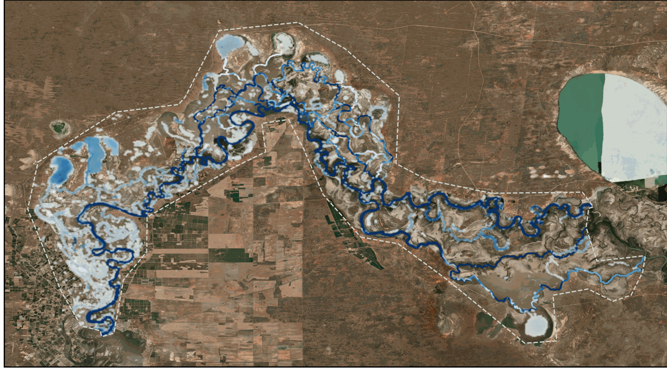
Flooding in the Chowilla floodplain simulated with the LSG
We applied the LSG model to two large study areas in Australia: the Chowilla floodplain (740 km²) on the border of South Australia, New South Wales, and Victoria and the Burnett River (1,479 km²) in eastern Queensland. The Chowilla floodplain is characterised by a flat topography with several anabranches, resulting in slow-moving water and long flood events that are regulated by several weirs and control structures for environmental watering. The Burnett River, on the other hand, has a steep topography with fast water flow and shorter flood events. For both case studies, the LSG model shows the ability to simulate the dynamic evolution of the flood inundation with similar accuracy to a high-resolution hydrodynamic model, but over 1000 times faster.
Using the methodology represents a big leap forward to providing accurate real-time ensemble forecasts of flood inundation. This would help inform flood management to make informed decisions before and during flood events to help protect lives and assets. In addition, the methodology could be used during the planning of new infrastructure to provide probabilistic design floods, and thus, ensure the infrastructure design will be robust and can help mitigate the impact of future floods. Future research will explore how this methodology can be adopted the urban areas that are known to be intrinsically challenging to model accurately, and how the LSG model can be coupled with weather and hydrological forecasts in operational real-time forecasting frameworks.
September 24, 2023 at 17:55
This is good work, but I have a problem with the fundamental premise that “Accurate flood inundation predictions are traditionally provided by running two-dimensional hydrodynamic models that solve shallow-water equations on a high-resolution numerical grid” — while perhaps the operative term is “traditionally” equally accurate and far-less computationally demanding are 1-D approaches, as are describe in “NWS/OHRFC Operational Experience with the Ohio River Community HEC-RAS Model” (https://doi.org/10.1061/41173(414)234) and “Results from Operational Hydrologic Forecasts Using the NOAA/NWS OHRFC Ohio River Community HEC-RAS Model” (https://doi.org/10.1061/(ASCE)HE.1943-5584.0001663), which describe The NOAA/NWS OHRFC Ohio River Community HEC-RAS Model, developed as a cooperative effort involving the OHRFC, USGS, and USACE. The physical scope of the model, which is unique in real-time hydrologic forecasting, includes 23 locks and dams on the Ohio River and tribu- taries, with numerous bridges, off-channel storage areas, and lateral structures, such as levees. The model comprises over 3,100 cross sections, spanning approximately 3,200 km of continuous modeled reach. The OHRFC runs the model daily, during routine operations, taking only a few minutes, to produce a 20-day simulation. The generation of accurate, near real-time flood inundation maps have been demonstrated at numerous locations, but are not part of routine operations.
September 25, 2023 at 09:45
Thank you for your interest in our research. I agree that 1D models can provide accurate predictions of flow and water levels in streams for large and complex river systems. The studies you refer to are good examples of this. However, in this study we focus on what happends once the water flows over the river banks and floods the surrounding floodplains. To model this we need to use 2d models to accurately capture how the water moves on the floodplain (See https://doi.org/10.1016/j.envsoft.2017.01.006 and https://doi.org/10.1146/annurev-fluid-030121-113138). It is of cause possible to use interpolation and bathtub methods, but they cannot provide the same accuracy as 2d hydrodynamic models. The reason researchers and engineers often still use 1d model for floodplain flooding in mainly because of the high computational demand of running complex 2d models. This is the problem we are trying to address in our research by creating a surrogate model that can accurately and efficiently approximate the results of the high-resolution 2d hydrodynamic model.