Devastating flooding in Myanmar/ Burma and Bangladesh
Contributed by Jutta Thielen, Annett Wania, Vera Thiemig, Xeni Kechagioglou, Ionut-Lucian, Peter Salamon, and Beatriz Revilla-Romero
Following a period of unusually heavy monsoon precipitation that started in mid-July and continued into August, Myanmar/Burma and (to a lesser degree) Bangladesh experienced the most severe flooding in decades. Heavy rainfall continued during the first half of the month of August, and more rainfall is forecast. This precipitation is associated with the South-West Monsoon, which is expected to last until October.
The extent and severity of the event only became apparent by mid-August: on 21 August 2015, the European Commission’s Emergency Response Coordination Centre (ERCC) reported 110 victims, 330 000 displaced households, more than 1.6 million people critically affected, and more than 15 000 houses destroyed. With about 1.5 million acres of farmland inundated, and 690 000 acres actually damaged at the onset of the planting season, it is expected that the country will also have to cope with the consequences of the flooding in the coming months, if not much longer. To date, river levels are still very high, particularly those of the Ayeyarwady River (Figure 1). The situation remains highly critical as more rain is expected.
Figure 1 illustrates an analysis of the ERCC from 19 August that shows the evolution of the flooded areas in the lower Ayeyarwady River from 10 to 17 August 2015, based on satellite imagery. The inundated area had increased by almost 20% in just over a week, from 3 982 km2 to 4 718 km2. An increase of 80% of inundated areas can be observed in the downstream sections of the river delta.
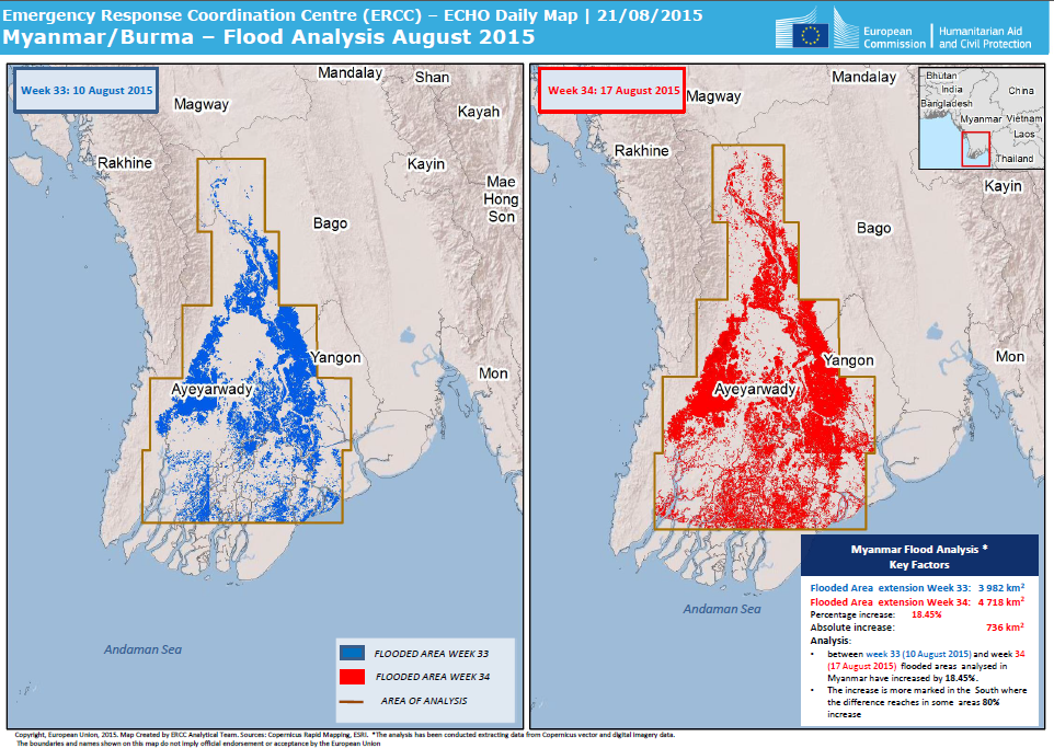
Figure 1: Comparison of flood inundation extent from 10 August 2015 (left) and 17 August 2015 (right) in the Ayeyarwady river basin, based on satellite image data (compiled from Copernicus EMS flood extent maps, see example in Figure 4).
Scientists of the Joint Research Centre (JRC) have supported the ERCC with information, maps, and analyses of the flood crisis. Even before the government of Myanmar/Burma requested support from the EU Civil Protection Mechanism (EUCPM) on 27 July 2015, JRC experts had already provided the ERCC with an overview of the severe weather situation, and on 6 August 2015, JRC experts provided in-depth analysis reports on the situation, and overview maps of the affected areas, population, and response actions taken (Figure 2).
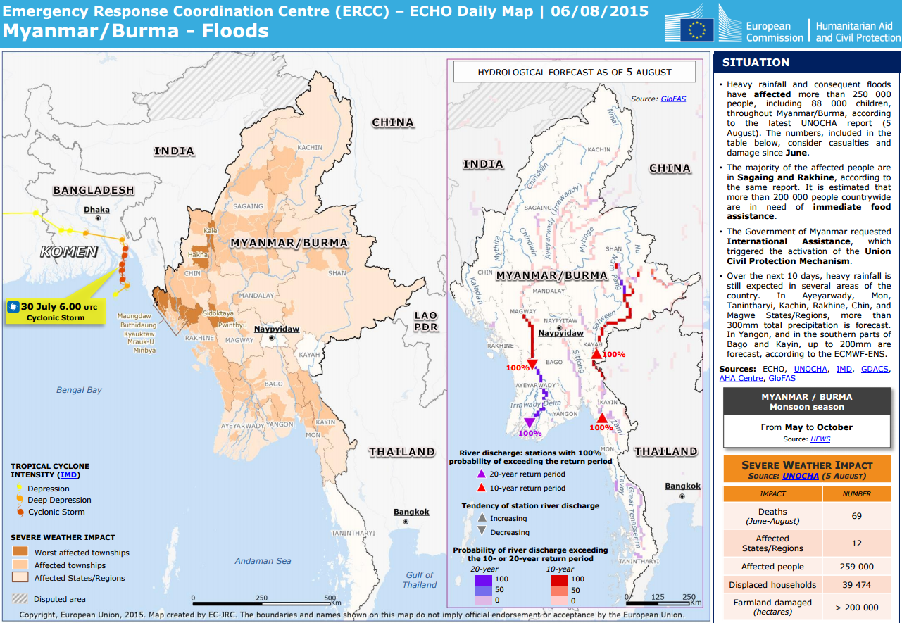
Figure 2: ECHO Daily Map of 6 August 2015, including GloFAS forecast.
The rainfall and flood forecasts from the Global Flood Awareness System (GloFAS), a joint development between the JRC and the European Centre for Medium-Range Weather Forecasts (ECMWF), provided useful information, particularly on where further rainfall and flooding was expected (Figure 2). The daily reports were provided to the ERCC with an analytical overview of the current and forecast flood situations. These reports indicated which Myanmar states were expected to receive further precipitation, and how this would translate into a hydrological response, i.e. an overview of the river stretches where the hydrological situation would be expected to improve or worsen. According to the GloFAS flood forecast, heavy monsoon precipitation starting in mid-July translated into a high probability of severe flooding several days before the actual flood peak (Figure 3).
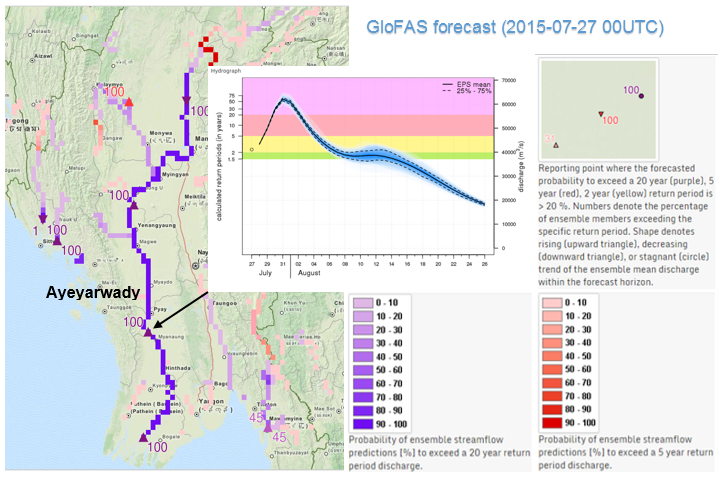
Figure 3: GloFAS Forecast (27/07/2015 00UTC) of the discharge predicted for the Ayeyarwady River, and the probabilities of exceeding the 5- and 20-year return periods.
The information was shared with local offices and authorities in Myanmar through the European Commission’s Directorate-General for Humanitarian Aid and Civil Protection (DG ECHO). It was also used to define areas for satellite-based rapid mapping of the floods by the Copernicus Emergency Management Service (EMS), which was activated by the ERCC on 7 August 2015. First maps showing the flood extent were delivered two days later for 10 districts (Figure 1, left). The flood extent continues to be monitored, and a first update was released one week later (Figure 1, right). The map in Figure 4 shows the widespread flooding of the Ayeyarwady River in the area of Hinthada, Myanmar. The information from the ECHO Daily Maps was further shared on 4 August 2015 through the Global Flood Partnership (GFP), and provided useful support to international aid organisations that are members of the GFP, such as the UN’s World Food Programme (WFP). Information from the JRC’s coarse-resolution satellite-based Global Flood Detection System was also shared within the GFP.
The flood forecasts and flood extent maps were provided within the frame of the Copernicus EMS, one of the six service lines offered by Copernicus – the European Union’s Earth Observation programme for global environmental monitoring and security. The JRC is the technical coordinator of the EMS, which provides early warning services, for example through as the European Flood Awareness System (EFAS) and its current extension to the global scale (GloFAS), and satellite-imagery-based mapping which provides support during or immediately after a crisis (Rapid Mapping), and for recovery, disaster risk reduction, prevention and preparedness activities (Risk and Recovery Mapping).
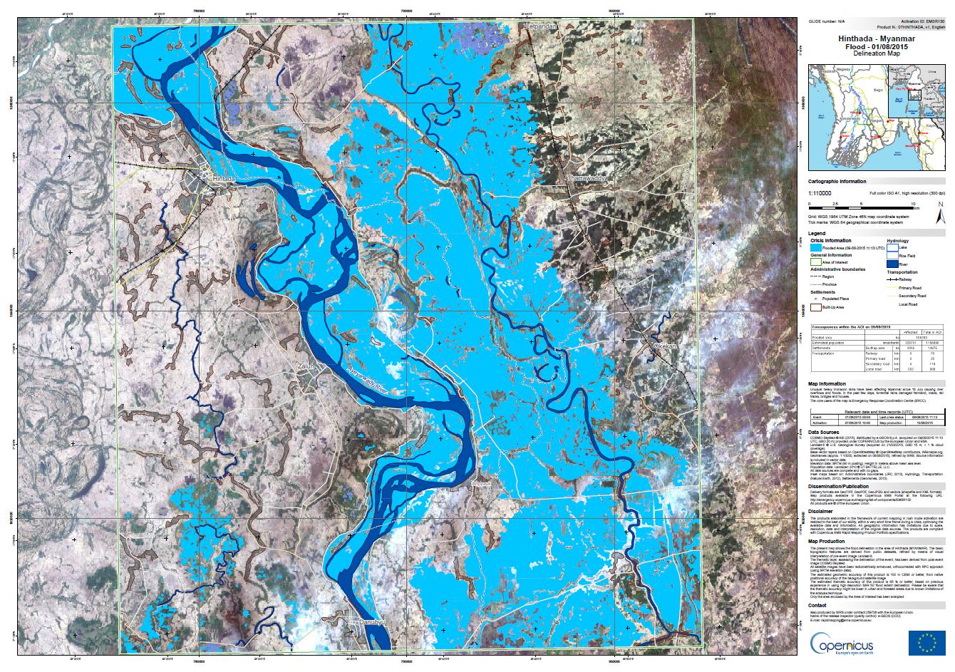
Figure 4: Copernicus EMS flood extent map for the Ayeyarwady River in the area of Hinthada, as published on 10 August 2015 (source: here).
Links:
- http://emergency.copernicus.eu/mapping/list-of-components/EMSR130
- www.globalfloods.eu
- www.copernicus.eu/
ECHO Daily Maps:
0 comments