How the community contributes to urban flood control
Contributed by Verônica Bernardes (MSc in Civil Engineering – Urban Drainage – CEFET, Minas Gerais, Brazil)
On September 4, 2015, I interviewed Solange Fonseca de Araujo, a specialist in Social Psychology, who works for the city of Belo Horizonte (the capital of the state of Minas Gerais in Southeast Brazil) as the coordinator of socio-related studies in urban drainage. Solange coordinates the so called NACs (in Portuguese, “Núcleos de Alerta de Chuva“), which are “Rain Alert Centres” (RACs) that were created by the municipality in 2009. The team has two people: Solange, coordinator, and a psychologist. I encourage everyone to read this post, which shows great contributions of the people to the academic and operational community!
You can also read the interview in Portuguese from here.
Verônica: What motivated the beginning of the work with the RACs?
Solange Fonseca de Araujo talks about social participation in flood protection
Solange: There was a major flood event at the end of the year 2008, beginning of 2009, when very heavy rain fell in a short period of time in the city. This situation generated flooding which caused severe and serious effects such as losses of property and lives. The City Hall and the people were taken by surprise. They had not experienced such a critical situation like this before. This pointed out to the need for the government to prepare for the occurrence of severe situations like this. Thus, we tried to know where the population was most vulnerable and how people could become less vulnerable to the occurrence of severe rainfall events.
V: So how did the activities begin with the RACs?
S: I was invited to set up a methodology for the development of the RACs. I always work with the idea that it is necessary to know the public, so as to develop an appropriate methodology. Therefore, the organization of these centres was, and still is, very dynamic. There is no strict format. It is important to listen and to be attentive to the population’s needs to develop activities that will really benefit them. The population needs to participate in this construction. The public and private dimensions should not be segmented, but should act together.
V: What were the first actions taken by the RACs?
S: First, we conducted an identification of the risk areas, where communities are most vulnerable, based on studies already done by the municipality, such as the city’s flood inundation map, and on studies carried out for the city’s Master Plan of Drainage. Also, we went to the various government agencies to collect information, such as the Civil Defence and the Fire Department. After that, we selected some areas and invited the residents of those areas to participate in a local assembly. In these meetings, we introduced ourselves as public power representatives, seeking to promote an ongoing dialogue with the population and create a regular communication channel.
This first contact was interesting because we understood that the communities were feeling helpless and frightened by the critical situation experienced on the last night of 2008. People were invited to participate as representatives of the community and as volunteers. All the communities that we visited joined the initiative. The volunteers were registered and so we started to communicate the rain alerts to them, so they could be prepared for a possible flood event. In addition to the assembly, we visited each of the areas and the local representatives showed us how things usually happened on the site: from where and how the water arrived in the area, the levels it reached, etc.
In these six years of work, we have understood that the flow of information is very dynamic, and our objective is to make sure that the collected data is used by the government, so that they can act in a positive way within that reality, either physically (eg., structural measures) or through non-structural measures, as a way to educate the public.
V: How do volunteers help in the RACs?
S: They have several roles: they know the area, know the people who live in that community, know how to be protected from a possible flood, etc. Besides, they receive the rain alerts and so they can spread the information to the community in which they live. For example, they help neighbours, they identify who the most vulnerable people are, and those who have limited mobility or illnesses. They also receive rescue training, such as how to launch ropes to remove someone from the river, and first aid training. For these representatives of the community, it is not compulsory but volunteer work in support of the City Hall.
V: Overall, once a RAC is implemented, how does it work during the rainy season?
S: The management team receives the rainfall forecast and communicate it to the volunteers via SMS. If the rain volume is important, the volunteers warn and mobilize the population of that area. If flooding occurs and people need help, the volunteer calls the Civil Defence and the Fire Department. Today, the Civil Defence already offers exclusive phone lines for the RACs. It is an ongoing work. In addition to this warning system, the RACs work with frequent inspections in the areas, and meetings are organized during the rainy season to increase their efficiency.
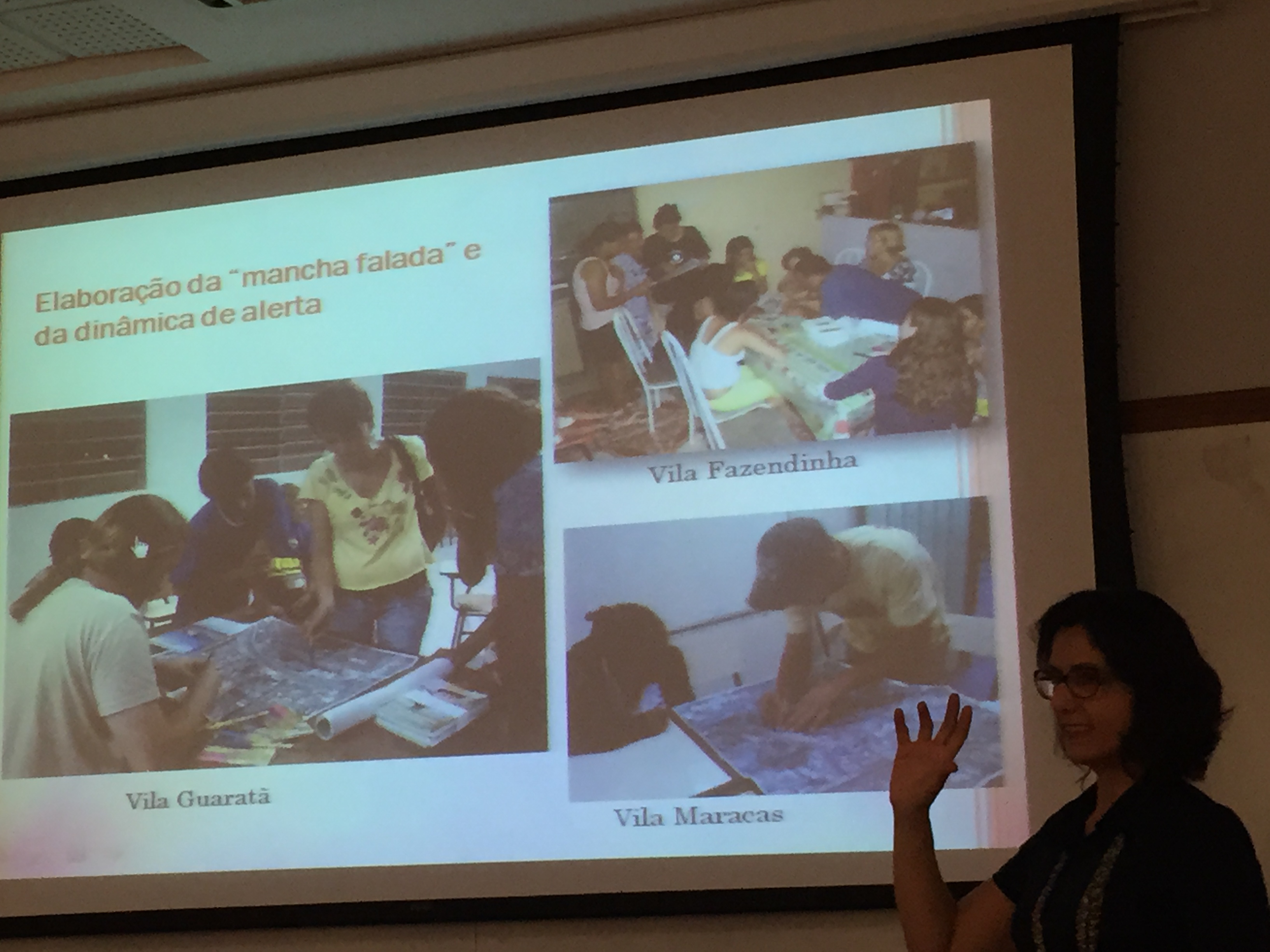
V: There is a “Community-Build Flood Inundation Map” (*) that you use in the RACs. What instrument is this?
S: The “Community-Build Flood Inundation Map” is a flood map that is designed by the local community with the participation of the management team. In this map, they mark the historical records they know from past floods, the areas that were flooded, etc. On this map, they point out the areas where the flooding level was higher (critical points), they locate where everyone lives in order to know which neighbours they will have to warn more frequently, and they identify emergency exits, among other issues they find relevant.
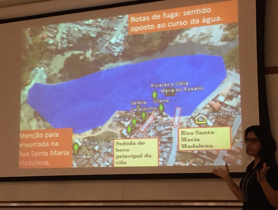
Example of a “Community-Build Flood Inundation Map”, explained by Solange.
V: What are the results so far?
S: Public agencies that are associated with flood control have had a positive return from the qualitative information they have received. For example, the flood inundation map of the city of Belo Horizonte has been adapted with information from the “Community-Build Flood Inundation Map”. Thus, these changes have brought structural and non-structural benefits for the regions in the city where the RACs are active. The RACs are part of the social map of the city. The communities involved in the RACs are always invited to participate in public forums. In addition, emergency agencies, such as the Fire Department, use the “Community-Build Flood Inundation Map” in their action plans. There are many positive results, including the population now being more prepared for flood events.
V: And what are the main challenges today?
S: I think a big challenge is to promote a greater degree of mobilization and participation of communities, through a greater contact with public agencies and through creating motivational campaigns. Another challenge is the work related to the rain forecast. The volunteer receives a rain forecast and often sends a warning to the community, which then acts according to all the guidelines that they have received (e.g., moving furniture to a higher place, taking the car out of the street or out of the garage, taking children to the highest points, etc.), but then rain may not occur. When this occurs several times, the community loses confidence in the information and starts to ignore it. They can then be caught by surprise if an event really occurs. Often neighbours stop believing the volunteers. To avoid this problem, our team always looks for ways to motivate and reinforce the importance of the performance of these volunteers in the community.
Another major challenge is to promote a better relationship between community knowledge and technical knowledge, i.e., to make experts adopt information and expectations of society. There are always conflicts and difficulties in understanding. It is always a big challenge to promote this relationship.
V: Thank you for your participation in this interview! Fell free to leave a final message for all readers of this blog post.
S: I am very happy to be talking about all this. It is a personal joy and I see this in a very positive way. I appreciate the opportunity to share these achievements and challenges. My final comment is about what I perceive when we work to build things together; in situations where there is the involvement of many different realities. We should consider that each reality, each situation, is unique, and however bigger our knowledge, there is still a lot we do not know. So, the other always has something to contribute to our knowledge. Respect for others is fundamental to developing any work.
(*) In Portuguese, “Mapa da Mancha Falada”
This interview is part of an initiative within the HYRADIER project (Hydrology from Radar Information), a STIC-AmSud Reseach and Innovation Program between Argentina (Universidad Nacional de Córdoba), Brazil (Universidade Federal de Minas Gerais) and France (Irstea and Université Pierre et Marie Curie).
0 comments