Hydrological forecasting needs and practices in Brazil
Contributed by Fernando Fan and members of the LSH Research Group Guest Columnist Team
Brazil is the largest country in South America, covering 8,515,767 km2, which corresponds to 47% of the continent. Two of the world’s major river basins are located in Brazil, namely the Amazon and La Plata, and much of its rivers and water resources are shared among Brazil and several South American neighborhood nations.
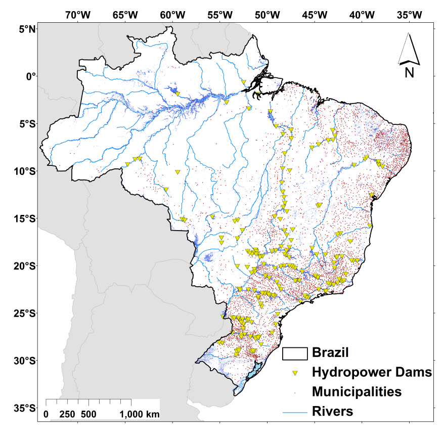
Figure 1. Brazilian municipalities, main hydropower dams and rivers (click on the image to enlarge)
Although part of the international attention on Brazilian water resources normally focuses on the Amazon basin, most of the country population is located in the South and South-east regions and along the coast, as can be seen by the distribution of municipalities in Fig. 1.
Important economical and societal impacts of flood hazards are frequent in Brazil. Some are related to flooding in the large Brazilian rivers and several others, to flooding in smaller rivers. Since the 70’s, more than 19 million Brazilians were affected by floods, according to the EM-DAT international disaster database.
Another important issue in Brazil is the use of water resources for energy production. A large amount of the large rivers are regulated by reservoir of hydropower dams (Fig. 1), and hydrological information is important not only for the optimization of energy generation but also for the operation that targets the mitigation of floods.
Role of flood forecast information
This brief description of Brazil highlights the important role that flood forecast information may have, but also some challenging features for the development of hydrological forecast systems. We can mention, at least, the following:
- the continental scale of the region,
- the transboundary nature of some basins,
- the diversity of climates and hydrological characteristics,
- the fact that flood hazards occur at multiple spatio-temporal scales and there is a need for forecast information at both, larger and smaller, rivers, and
- the extensive river flow operation by hydropower plants.
Short and medium range flow forecasts are basically used in the Brazilian context for two purposes: (i) the scheduling of hydropower reservoirs operation and (ii) flood forecasting at vulnerable locations, with a greater emphasis on the first one.
Forecasts for hydropower generation
It is not possible to describe the Brazilian forecasting practices without talking about hydropower reservoirs and power generation, as some reservoirs operate to mitigate flood impacts on upstream and downstream cities (see, for instance, Fan et al., 2014; Araujo et al., 2014).
Under normal flow conditions, The National System Operator (Operador Nacional do Sistema, or ONS) uses forecasts of average daily inflow with lead times up to 14 days to schedule the hydropower generation in the system. These forecasts are generated by ONS or by the dam operation agents (responsible for the plants) themselves using rainfall-runoff models or, more commonly, PARMA models.
The system is managed through an interconnected national system, the “Sistema Interligado Nacional” (SIN). When the inflows to SIN reservoirs is not at normal conditions, but in a state of “attention”, “alert” or “emergency” (defined from the level of expected volumes and any violation of hydraulic constraints), the operation of the reservoirs is usually not controlled by ONS, but carried out by the agents of the local power generation plant.
For such cases, forecast information also has great value to support decision making, especially during floods when the anticipated knowledge about an event provides valuable lead time for reservoir operation. Some reservoirs such the ones from Três Marias HPP, Estreito HPP, Foz de Areia HPP, Segredo HPP, and even Itaipu HPP have operational restrictions to help reduce or avoid downstream and upstream floods, and ensure dam safety.
Flood forecasts at vulnerable locations
Another use of forecasts that is growing in Brazil relates to human, economic and sanitary impacts of floods. Flood inundation has caused large negative impacts in the last decades, and according to the Emergency Events Database EM-DAT (CRED, Université Catholique de Louvain, Brussels), Brazil is among the ten countries most affected by floods in the world.
Great advances are expected in the coming years concerning the development of flood alerts systems, especially after the federal government of Brazil established a Center for Natural Disaster Monitoring and Alert (CEMADEN), led by the Ministry of Science and Technology (MCT). CEMADEN aims at developing, testing and implementing monitoring and forecast systems for natural disasters in Brazil. However, since it is a recently created center, operational flood forecast systems are still not fully developed.
Most of the operational flood forecasting systems in Brazil are led by the Geological Survey of Brazil (CPRM). It operates forecasting systems at vulnerable areas in some rivers, as Doce (MG), Caí (RS), Taquari (RS), Parnaíba (Piauí), Muriaé (RJ e MG), Negro (AM), Acre (AC), and Branco (RR). The forecasts are available at the CPRM website in a system called “SACE – Sistema de Alerta Contra Enchentes.” These forecasts are performed using data-based models, and present generally good performance for short lead times, usually less than 3 days.
And what about ensemble forecasts?
Currently, there are several efforts to develop forecasting systems in Brazil, ranging from simple statistical models to state-of-the-art methods using distributed hydrological models coupled to ensemble meteorological forecasts.
Works such as Fan et al. (2014), Fan et al. (2015a, 2015b) and Schwanenberg et al. (2015) showed great possibilities and advantages for the use of ensemble forecasts, in comparison to the use of deterministic forecasts, as is currently done for flood anticipation and reservoirs operation (Figures 2 and 3). These works are however decentralized, as current hydrological forecasting systems are being developed for specific rivers at several different places (e.g., at universities, regional hydrologic centers and by the hydropower sector).

Figure 2. São Francisco, Tocantins, and Doce river basins, the test areas of Fan et al. (2015a)

Figure 3. Mean Continuous Ranked Probability Score (CRPS) results for the three tested locations by Fan et al. (2015a) (click on the image to enlarge)
A lot more still to be done
Although there is know-how on state-of-the-art hydrological forecasts in Brazil, at this moment, it has not converted into a countrywide operational flood forecasting system.
There is not also a clear picture about the exchange of information between forecasting centers or, for example, between operational forecasts generated to be used by hydropower companies and forecasts generated to be used by local early flood warning systems for the same river basin – even though forecasting systems for hydropower reservoirs are, to some extent, intended to help flood warning and flood response.
Also, currently there is not a countrywide or continental forecasting system in Brazil, such as EFAS and AFFS, although proposals for the development of such systems have been discussed. We have also promoted discussions on the use of probabilistic forecasts for decision-making during national conferences, following the examples from the games developed under HEPEX (see a recent paper in Portuguese here).
We believe that the Brazilian scenario may change in next years, with the growth of regional and countrywide forecast systems through the development and transfer of technological knowledge and the growth of institutions as CEMADEN, which currently receives the information of the GLOFAS system.
Do you want to know more?
We strongly invite you to visit our poster at the “Ensemble hydro-meteorological forecasting” session organized at EGU 2016. The poster is EGU2016-8608 and the display time will be Monday, 18 Apr 2016, 08:00-19:30 at board number A.192. We will not be there, but Maria-Helena Ramos will be glad to present more details to you!
Also, we would like to recommend the Chapter “Hydrological Forecasting Practices in Brazil” in the book “Flood Forecasting: A Global Perspective” by Thomas E Adams (Editor) and Thomas C. Pagano (Editor).
A list of references for this post can be downloaded here.
April 5, 2016 at 13:25
Hi Fernando, great post. What do you and your team think the biggest barriers are to a countrywide operational flood forecasting system, and to a better exchange of information between forecasting centres?
April 7, 2016 at 23:59
Hi Liz,
Thanks for the comment!
For both questions I think the answer is pretty similar. The greatest barrier until 2012 was the lack of a national disasters monitoring center. Now that CEMADEN (Center for Natural Disaster Monitoring and Alert) was created, the barrier is the he lack of maturity from the Center. I believe that with time those questions will be improved when CEMADEN take the leadership of this kind of project.
Here at my Institute, we are working at technical issues for the development of South American systems, aimming to colaborate straight to CEMADEN in the near future.
Best Regards,
Fernando
April 21, 2016 at 10:35
Hello Fernando, interesting post.
I’m thinking about the flash floods in Brasil, do you think that the ensemble prediction system can help to predict flash floods in São Paulo?
Best Regards,
Angelica.
April 22, 2016 at 04:02
Hi Angelica,
Thanks for the comment!
Indeed I think we have an opportunity to use ensembles at this case. Although I would say that radar based ensemble precipitation may be more useful for such a fast-response system.
Best Regards,
Fernando
April 22, 2016 at 09:15
Thank you Fernando for your answer. Yes, it is a good idea. Maybe combine both ensembles, for ex. the prediction can starts with the radar ensemble prediction (for the first two hours) and for the next hours the NWP can be applied.
Best regards,
Angelica.