Helping shape a new flood forecasting service in The wellington region, new zealand
Contributed by Michael Cranston (RAB), Andy Brown (Greater Wellington Regional Council) and Bapon Fakhruddin (Tonkin and Taylor).
The flooding challenge in Wellington
Greater Wellington Regional Council (GWRC) are embarking on a programme to establish improved flood forecasting services across the Wellington Region on New Zealand’s north island. Flooding is considered New Zealand’s number one natural hazard with flood emergencies estimated to have cost $17 million a year in insurance payments and $15 million in emergency management expenditure between 1968 and 2017.
The climate of the region is dominated by the presence of Cook Strait and the rugged local topography. The Tararua and Rimutaka ranges generate a very strong orographic component to rainfall, with typical annual rainfall ranging from 800mm in the east, to over 6000mm across the mountain ranges. As a consequence, major flood events have occurred in recent years include Porirua (2004), Masterton (2018) and close to Wellington itself on the Hutt River (2005).
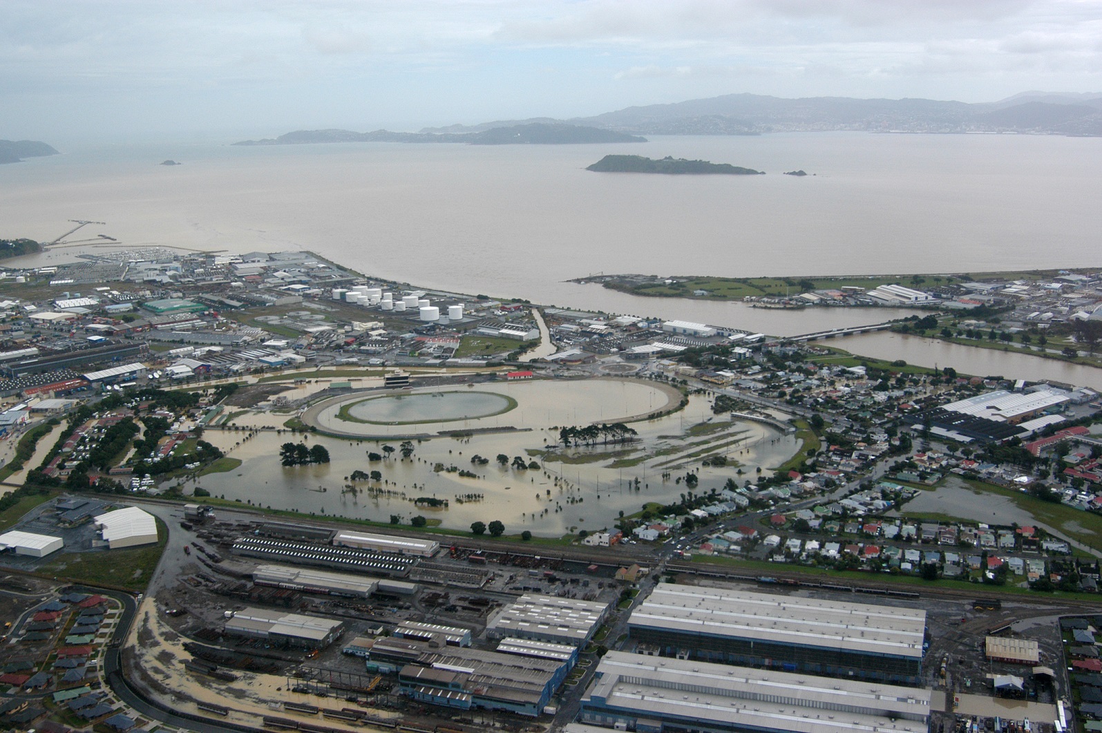
Figure 1: Flooding on the Lower North Island (Source: Ministry of Civil Defence and Emergency Management https://www.civildefence.govt.nz/resources/photo-library/)
In the Wellington Region flood risk is currently managed by Greater Wellington Regional Council (GWRC), Territorial Authorities, and Wellington Region Emergency Management Office (WREMO). GWRC’s Flood Protection department are looking to deliver key flood risk management work on behalf of the region including improving the understanding of flood risk through modelling and mapping programmes, maintaining flood protection through river management and asset maintenance and by delivering new capital schemes to improve flood security.
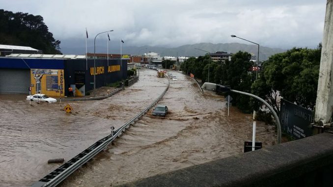
Figure 2: Flooding in Wellington in May 2015 (Source: Newsbeat https://www.newsbeat.kiwi/2015/05/17/floods-shut-wellington/)
Now plans are being developed to minimise the damages caused by flooding through enhancing flood early warning systems using state of art technologies following a recent review of flood warning services.
Developing improved approaches to flood forecasting
It has long been recognized that if communities could be provided with advance flood warnings, the adverse effects associated with it could be minimized. One of the objectives of this project is to improve the capability to forecast and warn for future flood events and to enable proactive emergency management. The work will look to international best practice in detection and forecasting of floods and set the future direction of more effective early warning.
At present the flood warning (hydrometric) network consists of 25 raingauges and 26 river flow stations, all continuously supported by a team of flood warning duty officers. GWRC currently operate flood forecasting models for the Otaki, Waikanae, Waitohu, Hutt and Wainuiomata catchments using Hydrol Modelling (part of Hydrotel) in addition to some applications of the Australian Water Balance (AWBM) and the NAM models. The MetService, who operate numerical weather prediction (NWP) systems for the country, are also supporting GWRC through the integration of NWP precipitation forecasts to support flood forecasting and there are aspirations to move to an ensemble-based approach to forecasting.
Andy Brown, Team Leader at GWRC said: “Our Flood Protection Team are seeking to improve our flood forecasting and warning capability to improve our response to major flood events. A number of important communities in our region are built on flood plains and are at risk of flooding. We have seen events in recent years in other regions and want to be prepared should a large event hit our region. It is our aspiration to have a robust and appropriate flood forecast models operating in our region.”
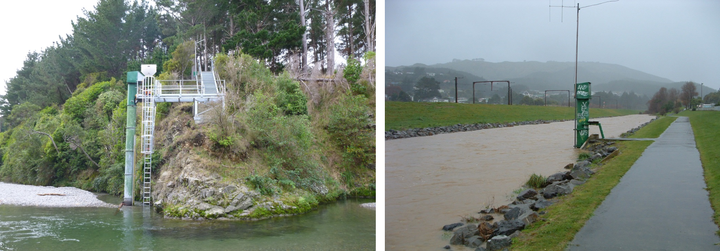
Figure 3: River and Flood Monitoring carried out by Greater Wellington Regional Council (Source: GWRC)
Calling on flood forecasting system developers!
Key to the success is to understand what modelling approaches might be suitable for the flooding challenge in Wellington and how this could be supported through a flood forecasting platform. This is where we are looking to the flood forecasting community to help shape this project.
If you are involved in forecasting model development, probabilistic forecasting or platform provision, then please email gwrc_floodwarning@tonkintaylor.co.nz if you would like to support this study. We will be circulating a short questionnaire to those interested to gather information on forecast modelling approaches and systems. GWRC will then retain your details for future opportunities to be involved in the development of the GWRC flood forecasting service.
0 comments