Operational HEPS in France: the country-wide Météo-France system
Contributed by Fabienne Rousset-Regimbeau, Guillaume Thirel and Florence Habets
Being the French meteorological and climatic service, Météo-France’s first mission is to warrant the meteorological safety of human beings and goods. For doing so, warning maps are produced every day for all of France and are communicated to the public and authorities. Dangerous phenomena such as storms, avalanches, storm surges, snow falls, cold and heat waves are displayed.
Flood risks assessment is also included: it is estimated in collaboration with the SCHAPI, the French Flood Forecasting Service, which produces more detailed hydrological warning maps and information bulletins in case of alert. These maps and bulletins only refer to a 48 h lead time. The short-range (1-2 days) forecasts are made on a regional scale by the 19 local forecasting centres (SPCs), which use a diversity of hydrological models and the forecasters’ expertise.
Beyond this lead time, the SCHAPI uses different approaches, including the medium-range (3-10 days) HEPS forecasts that are provided by Météo-France on all of France through persistence graphs (Figure 1) or spaghetti and boxplots hydrograms. This HEPS, performed using a single hydrological model, is the one presented in this blog post.
Medium-range HEPS forecasts provided by Météo-Francee
By using the forecasts produced by the HEPS of Météo-France, the SCHAPI’s aim is twofold: having homogeneous probabilistic forecasts for the complete French territory, and being able to have information about flood risk several days ahead. This increased lead time is particularly important for planning the stand-by duties of hydrological forecasters. Moreover, when an event is forecast by the HEPS several days consecutively, its probability of occurrence is reinforced.
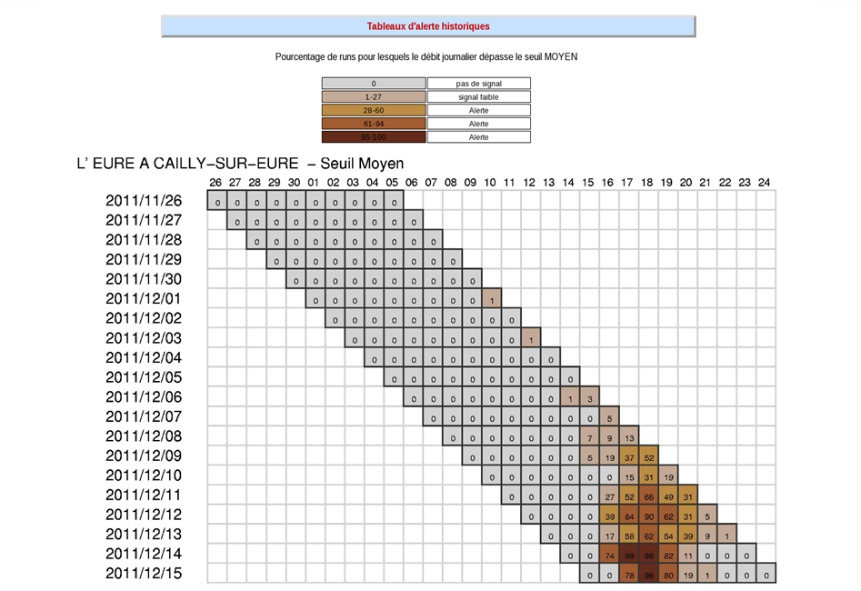
Figure 1: persistence graphs of a flood threshold exceedance. The dates on the left represent the dates at which the forecasts are issued, the dates on the top represent the forecast horizon. Darker colours indicate higher probabilities of exceedance.
The Météo-France HEPS runs operationally since 2004. It relies on the physically-based Safran-Isba-Modcou hydro-meteorological suite. Safran provides the observed meteorological input, Isba is the soil-vegetation-atmosphere-transfer model, classically used within meteorological models, which provides the runoff and drainage water fluxes on an 8×8 km grid, and Modcou is a hydro-geological model developed by Mines ParisTech, computing discharge on around 900 river gauges (Figure 2, left side).
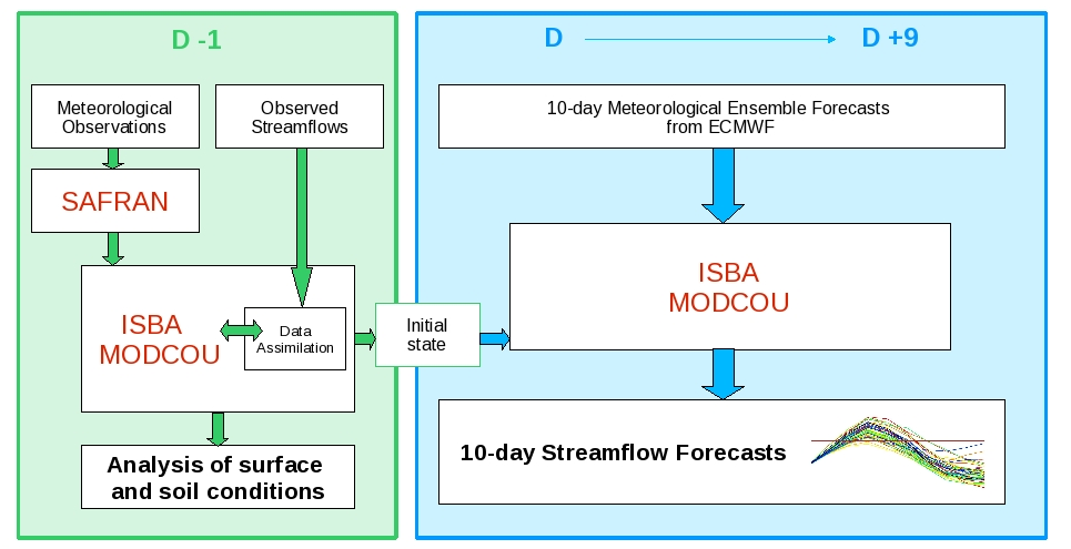
Figure 2: principle of the HEPS.
As such, this system is run on a daily basis to obtain an analysis of the conditions of the previous day. It is used for monitoring the current hydro-meteorological conditions over France, especially the drought conditions, but also other specific events such as snowfalls or heatwaves. It also provides the initial states of the forecasting system, which is fed by the ECMWF 10-day EPS precipitation and temperature forecasts for producing discharge forecasts (Figure 2, right side).
Data assimilation scheme
A data assimilation system making use of observed discharge has been implemented for improving the HEPS forecasts. Accordingly to the objective of this system is the medium term, the DA has been developed as follows: instead of trying to update the river water amounts, whose effect would be immediate on discharge, the soil moisture has been chosen (see the description of the DA system in Thirel et al., 2010a).
The longer memory of soil moisture allows for improvements of the deterministic and probabilistic skills of the system more than 7 days after DA (see the impact of DA in Thirel et al., 2010b).
For taking into account the heterogeneity of the hydrological and meteorological properties of the catchments, the DA system works on a semi-distributed base: the catchments are divided in sub-catchments depending on the availability of observed river gauges. The DA BLUE algorithm, which makes use of model and observation errors but does not include a probabilistic framework, has been chosen. It allows obtaining a better initial state, from which all the members of the ensemble then start.
Following the positive results of this DA system, it has been implemented in the operational Météo-France HEPS in 2014, together with an upgrade of the ECMWF EPS used as input, and with an improvement of the Isba model. An assessment of the separate and combined effects of these modifications has been made in Coustau et al. (2014) under real-time conditions. This study shows the positive impacts of the improvements for a period of 18 months. Moreover, some of the stations that are not assimilated also benefited from DA due to the physics of the model, since they are included in or located downstream of assimilated catchments (Figure 3).
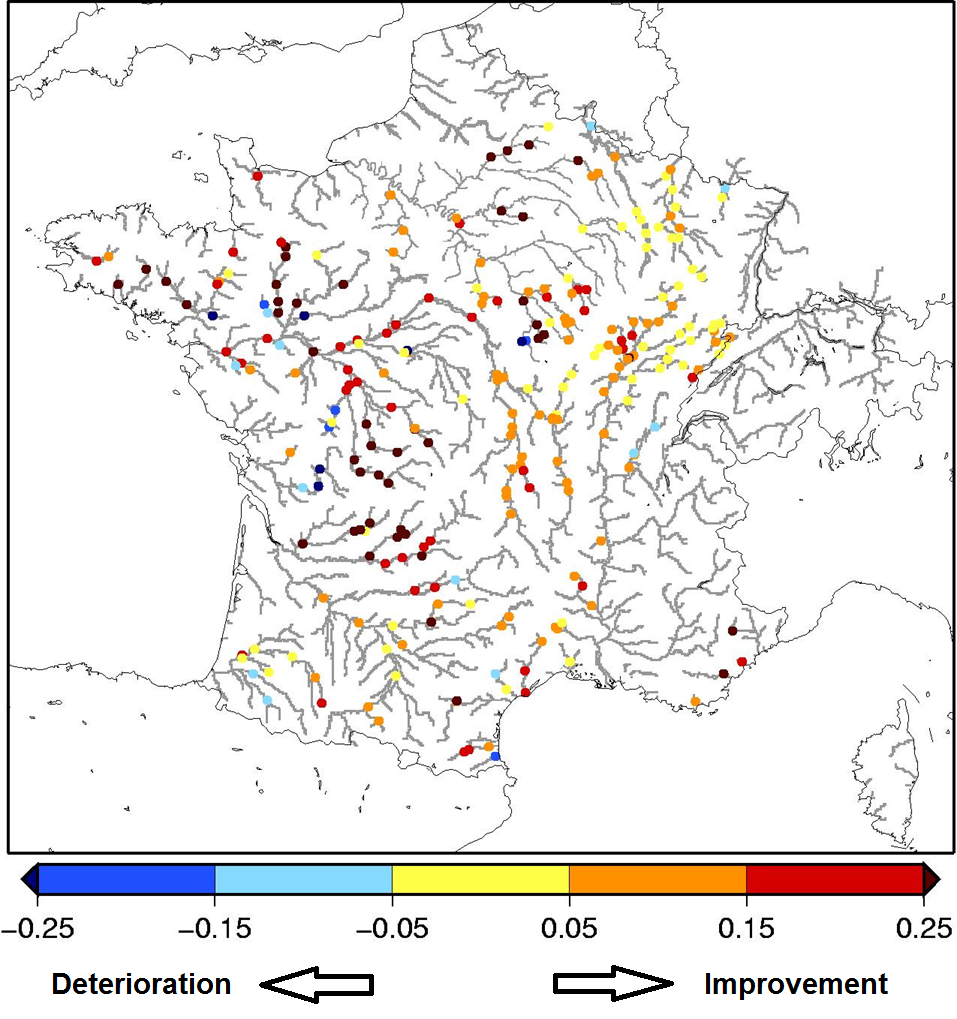
Figure 3: Improvement of RPSS of 7-day HEPS forecasts when the Isba model is improved and DA is implemented compared with no DA and use of the normal Isba model. Score calculated over 19 months (Jan 2010 – Jul 2011) under real-time conditions.
For the future…
Some improvements can be foreseen:
- Statistical unbiasing of the ECMWF EPS is currently not performed; however, preliminary tests did not show, until now, any evidence that resulting HEPS forecasts would be improved.
- More promising could be the replacement of the BLUE with an ensemble-based DA technique; the initial state uncertainty assessment could improve the statistical properties of the HEPS forecasts.
- Model uncertainty could be assessed through a multi-model approach as is going to be experimented with EFAS or through using multiple model parameterizations.
- Finally, recent works showed the positive impact of post-processing of HEPS forecasts and this could be tested in the system.
References:
- Coustau M., F. Regimbeau, G. Thirel, F. Habets, B. Janet, E. Martin, C. de Saint-Aubin, J.-M. Soubeyroux: Impact of improved meteorological forcing, soil physics and data assimilation on an operational Hydrological Ensemble Forecast System over France, Journal of Hydrology, submitted, 2014.
- Thirel G., E. Martin, J.-F. Mahfouf, S. Massart, S. Ricci, F. Habets: A past discharges assimilation system for ensemble streamflow forecasts over France – Part 1: Description and validation of the assimilation system, Hydrol. Earth Syst. Sci., 14, 1623-1637, doi:10.5194/hess-14-1623-2010, 2010a.
- Thirel G., E. Martin, J.-F. Mahfouf, S. Massart, S. Ricci, F. Regimbeau, F. Habets: A past discharge assimilation system for ensemble streamflow forecasts over France – Part 2: Impact on the ensemble streamflow forecasts, Hydrol. Earth Syst. Sci., 14, 1639-1653, doi:10.5194/hess-14-1639-2010, 2010b.
September 11, 2014 at 10:52
A nice overview of the French system. However, the sentence ”Statistical unbiasing of the ECMWF EPS” worried me, as always when the word ”bias” turns up in texts. Strictly mathematically-statistically “bias” means a quasi-constant difference, such as “always about 2 degrees too warm”. Subtracting 2 deg. will fix the problem.
But my experience with general verification and statistical interpretation has told me that “systematic” errors can be systematic in more complex ways, for example being a linear function of the forecast itself. The MOS technique tries to find which predictors (plural) that can “forecast” the error.
At least for temperature and wind the simple linear model
Correction = A + B*Forecast
not only corrects for mean errors (true biases) but also the spread – at the same time. This seems to be difficult to realize because I have spent hours trying to persuade colleagues who believe that they needed one system to correct for the “bias”, another to correct for the spread.
The formula above does not work for rainfall, but surprisingly well
for rain p r o b a b i l i t i e s! But as Fermat said… “J’en ai découvert une démonstration véritablement merveilleuse que cette marge est trop étroite pour contenir.”
What I didn’t find in the text was a reference to the T1279 ECMWF model, also beyond the first days. In my User Guide I discussed this problem in a rather “hand waving” style. Intuitively, if intuition is at all to be relied on, I “feel” that this information, from the last 3-4 runs combined with the EPS, would improve the forecast quality in one way or the other.
September 17, 2014 at 14:47
Dear Anders,
Thank you for your comment.
You are completely right regarding the sentence “Statistical unbiasing of the ECMWF EPS”, we misused the word unbiasing here. What we meant there was rather pre-processing of the ECMWF EPS before using it in the hydrological model, more especially ensemble-dressing methods applied to the ECMWF EPS.
Unfortunately we did not understand your last paragraph. Could you please specify what you mean?