Probabilistic radar rainfall fields for ensemble prediction in urban hydrology
Contributed by Sara Liguori, University of Bristol, UK
 The real-time control of urban drainage systems involves operations on control devices (e.g. mobile gates, variable crest weirs, variable speed pumps) set to reduce, for instance, the frequency and volumes of combined overflows from the sewer network of an urban area into the receiving water bodies, and the associated increase of pollutant loads (suspended solids, ammonia-nitrogen, heavy metals among others).
The integrated use of radar rainfall estimates and radar-based rainfall forecasts as drive to the modelling of runoff and sewer flows in the urban area can actually enhance the effectiveness of such control decisions, as well as reducing the impact of urban flooding linked to high-intensity or prolonged rainfall events and to an inadequate capacity of draining canals and sewers.
The potential value of the use of radar rainfall data is urban hydrology is linked to the fact that weather radars provide distributed estimates of rainfall with high spatial and temporal resolutions (e.g. 1 km and 5 minutes). In addition, radar estimates can be used to perform short-term (0-6 hours) rainfall forecasts (radar nowcasts) based, essentially, on the extrapolation of the future rainfall distribution from a series of consecutive radar images. The challenge in the use of rainfall forecasts in urban hydrology is in that the most accurate forecasts must be achieved in the forecast horizon between 30 minutes and 2 hours, which makes the use of radar nowcasts very appealing for this kind of applications. In fact, the skill of radar nowcasts decreases rapidly with the forecast lead time, but is high in the very short forecast horizon if compared to rainfall forecasts from Numerical Weather Prediction (NWP) models.
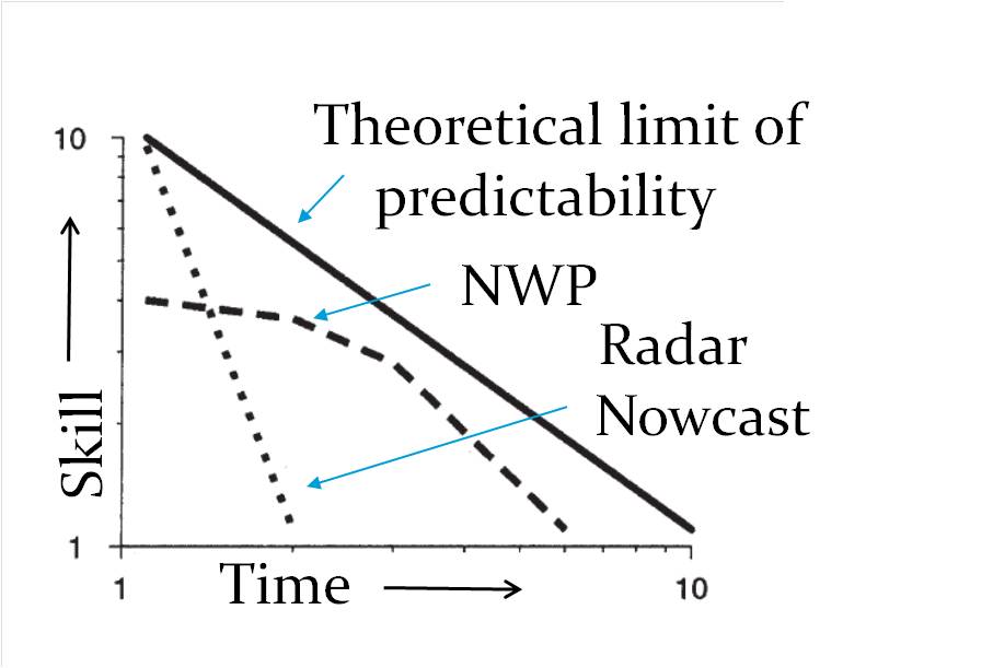
After Golding (1998)
The actual use of radar estimates and forecasts of rainfall in urban hydrological applications is, however, limited by the inherent uncertainty affecting the estimate of rainfall by weather radars (data uncertainty) due to various sources (e.g. ground clutter, anomalous propagation, vertical reflectivity profile, bright band) and by the approximations in the modelling of the temporal evolution and motion of the rainfall field by nowcasting models (model uncertainty).

Radar ensembles obtained by summing a stochastic perturbation field (incorporating information on the spatial and temporal characteristics of the radar error) to the original unperturbed radar rainfall field.
Various approaches have been implemented to address the uncertainty in radar rainfall estimates, including empirically based methods (product-error driven models) which aim to provide an estimate of the combined effect of all sources of error via comparison with a reliable reference (e.g measurements from rain gauges). Current approaches aim to model the residual errors in radar rainfall estimates (i.e. after the application of suitable correction techniques) through ensembles generated by adding to the deterministic radar rainfall field a stochastic component, which can incorporate information on the spatial and temporal structure of the radar error.
Similarly, a stochastic approach has also been implemented for the purpose of probabilistic radar nowcasting. The STEPS (Short-term Ensemble Prediction System) model has been developed by the UK Met Office and the Australian Bureau of Meteorology to produce ensemble forecasts by modelling a stochastic noise component to account for the uncertainties associated with the nowcasting process (i.e. limitations in modelling growth and decay of precipitation and the advection of the precipitation field). The STEPS model has the additional capability of merging radar nowcasts with NWP rainfall forecasts, as it has originally been developed to merge the skill of radar nowcasting and NWP systems at different forecast lead times.

The STEPS model has been tested for the prediction of flows in the sewer system of a small urban area in the North of England, using NWP rainfall forecasts from the NWP model MM5 (NCAR/Penn State University).
An Infoworks CS model using rainfall as the primary input has been implemented to simulate the rainfall-runoff process in the urban area and the flow through the sewer conduits. The sewer network is covered by 25 radar pixels with a spatial resolution of 1 km2. The majority of the sewer system is combined, carrying both urban rainfall runoff as well as domestic and trade waste water. The results of the implementation of ensemble rainfall forecasts from the STEPS model showed a potential for use of a system of this kind to provide qualitative warnings on flooding in the urban area.
In order to focus on the propagation of the uncertainty from radar rainfall estimates into sewer flow predictions, a radar ensemble generator has also been set up and implemented for the same case study using radar rainfall estimates at 1 km and 5 minutes from the UK Met Office weather radars and measurements from more than 200 tipping-bucket rain gauges managed by the UK EA (Environment Agency).
The hydrological implementation of radar ensembles for sewer flow predictions is promising and needs to be explored further for the purpose of real-time applications. More work still needs to be done in improving the urban models and assessing the additional sources of uncertainty associated with the structure of the urban models and the large number of parameters they require.
0 comments