Streamflow flood monitoring and forecasting over Africa with little data
By Justin Sheffield (Princeton University)
Recent flooding in Mozambique caused almost 100 deaths and displaced 150,000 people, with extensive damage to infrastructure. Forecasting such an event is a challenge because of the scarcity of on-the-ground data and lack of capacity in many parts of Africa, despite the great need. This post shows some results from the Princeton University African Flood and Drought Monitor (AFDM), which uses satellite precipitation and hydrological modeling to track large-scale surface hydrology, and weather/climate model output to drive hydrological forecasts at short-term to seasonal time scales. This approach shows potential to contribute to flood (and drought) early warning in data-scarce regions of Africa.
African Flood and Drought Monitor (AFDM)
The Princeton AFDM has been developed over the past several years, originally to demonstrate the potential for tracking drought conditions across Africa using available satellite products and modeling technologies. The system has evolved to now provide daily updates in near real-time (2-3 days lag) of surface hydrology, streamflow and vegetation stress, short-term hydrological forecasts for flooding, and seasonal forecasts for drought and agricultural impacts. The system has been installed at regional centers in Africa and we have carried out training workshops with representatives of national meteorological and hydrological agencies and river basin management authorities.
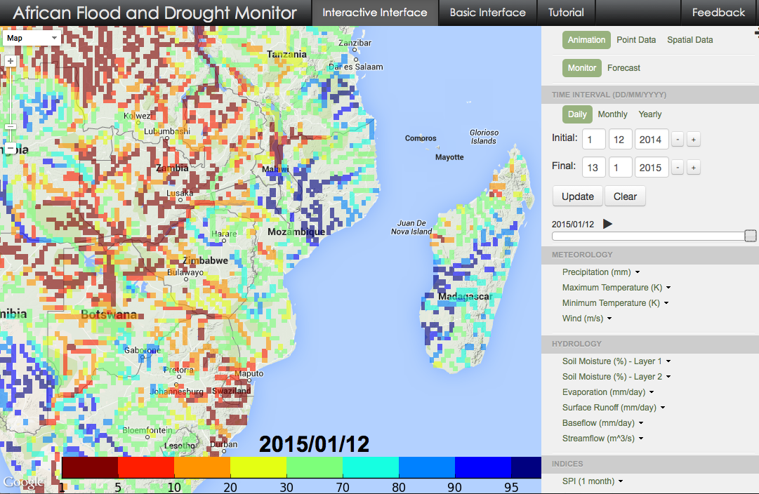
Below is a screenshot from the online system showing the recent flood conditions for east Africa in terms of modeled streamflow percentiles for 2nd order streams and higher indicating the large values over central-eastern Mozambique and western Madagascar. The streamflow is modeled using a grid-to-grid routing model on a fairly coarse resolution 25km grid.
The hydrological model is calibrated at large-scales to publically available streamflow records from the Global Runoff Data Center (GRDC), which number in the several hundred for sub-Saharan Africa as a whole, but are generally only available for large basins and are often at monthly resolution for periods several decades ago. The historical meteorological data is based on global datasets that include very few gauges on this continent, especially for recent years. The short-term hydrological forecasts use NCEP Global Forecast System (GFS) precipitation and temperature forecasts, which are bias-corrected against the global datasets of mean monthly precipitation, but otherwise are used as is to drive the hydrological model. So with these limitations, how does the system fare and can it provide useful forecasts for such events?
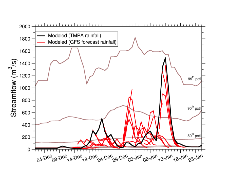
The next figure shows the 7-day streamflow forecasts during last December and January for the Licungo River near the Mozambique coast compared to the observation forced simulation (in lieu of streamflow observations). The Licungo River took the brunt of the flood impacts with the river reported to be at record levels. The forecasts shown are the ensemble mean for each day starting from about 4 weeks before the event through to the peak day of the flood. The forecasts do a reasonable job of reproducing the observational estimate with some false peaks at the start of January, although we have no information on the actual streamflow for this event.
So the system is capable of identifying flood conditions and forecasts without the use of local information and local calibration – but there is still a long way to go before it can provide useful forecasts that are reliable and relevant. The forecast part of the system has been mostly evaluated in terms of seasonal drought forecasts and the flood side of things is a relatively new aspect of the system, so a formal evaluation is needed. The lack of readily available observed data for streamflow for recent years makes this difficult for anything but very targeted applications.
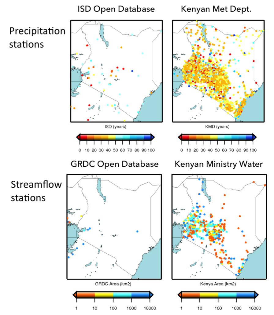
The good news is that data for many precipitation and streamflow gauges do actually exist, historically and often in real-time. For example, for Kenya, global gridded precipitation datasets that form the basis for the AFDM climatology contain information from about 20 precipitation stations (see figure below). Yet the Kenyan Meteorological Department has records for almost 3000 precipitation stations many of which are operational. For streamflow, the GRDC holds data for a handful of stations – the Kenya Ministry of Water has records for about 850 streamflow stations. The situation is similar in many other countries. Merging the wealth of data from national agencies into the system would have tremendous impacts on its skill for monitoring and forecasting. Whether these data can be obtained is another matter and it can take years to develop the necessary funding and collaborations.
We are currently working with UNESCO-IHP and collaborators in Kenya and Zambia to test the potential improvements at local scales. Other ongoing improvements include implementing a flood inundation model – river flow forecasts are useful but forecasts of flooded area are also important – and assimilating available rainfall and streamflow/water level data into the system to make local adjustments to the predictions.
Implementing flood and drought monitoring and forecasting for regions with generally low data availability and capacity is possible based on readily available satellite products and modeling technologies. The challenge for our group and the forecasting community is to translate this potential into reliable and robust forecasts that can provide early-warning of flood and droughts events in regions with the most need.
The system is accessible online here: http://stream.princeton.edu and documented in a recent paper in the Bulletin of the American Meteorological Society (A Drought Monitoring and Forecasting System for Sub-Sahara African Water Resources and Food Security), which focuses on the drought side of things.
0 comments