Summer 2018 in Europe: did the EFAS seasonal outlook predict low river flows?
— this post is jointly published on the blogs of HEPEX and the European Drought Centre —
Contributed by Louise Arnal (ECMWF and University of Reading), Shaun Harrigan (ECMWF) & David Lavers (ECMWF).
Summer 2018 in Europe was remarkable from a hydroclimate perspective, with large regions experiencing persistent dry conditions, very little to no rainfall for extended periods, a series of heatwaves with record-breaking temperatures and numerous wildfires (in the UK, Sweden, Greece, Spain, Portugal, Latvia and Germany, among others). According to the Copernicus Climate Change Service (C3S), the European-average surface temperature anomaly was 1.7°C for July 2018, making it the 2nd warmest July on record since 1980 (click here for more info). The UK Met Office stated that 2018 was the warmest summer on record for England.
This extreme event was caused by persistent blocking high-pressure systems situated over northern and central Europe and formed part a summer variation of the North Atlantic Oscillation (NAO) pattern. Blocking high-pressure systems are associated with light winds and sunshine and prevent low-pressure systems, that can bring strong winds and rain, from reaching much of Europe.

Figure 1: Photo of the dry south-eastern coast of England (top) and of the low flows in the River Rhine river (bottom), on 3rd August 2018. Credit: Louise Arnal
These meteorological conditions have translated to severe hydrological impacts over the past three months. According to the European Drought Observatory (EDO), most of central and northern Europe is now affected by a drought resulting in very dry soils, rivers, groundwater levels, and reservoirs. For example, record breaking low flows on the River Rhine are causing major disruption to river shipping. Whilst the event unfolded, the hydrological community has been very active, posting on social media up-to-date and informative communication on the developing hydrological situation and its impacts; see for example Twitter feeds under the #EuroDrought18 topic.
Here, we look back at the hydro-meteorological anomalies that developed over the summer and see how well the EFAS (European Flood Awareness System) seasonal outlook1 of the Copernicus Emergency Management Service (CEMS) did at capturing the low river flow conditions in Europe.
Summer 2018 hydrological situation
The defining feature over June-July-August 2018 was the growth in spatial extent of low flows across the European river network, given here by the daily EFAS water balance simulation (EFAS-WB)2 (Fig. 2). On 11 June, 12.4% of the river network length was in a low flow anomaly (i.e. below the 10th percentile of the long-term EFAS-WB daily climatology). On 11 July, the low flow anomaly extended to 25.2% of the river network, and covered over one third (35.1%) by 11 August. The maximum spatial low flow extent for the summer was 41% on 24 August.
Figure 2: Evolution of the hydrological situation from the EFAS-WB from 1 June to 31 August. Red (blue) river pixels show EFAS-WB discharge below (above) the 10th (90th) percentile of the long-term (1990-2014) daily climatology
EFAS seasonal outlook for the summer 2018 low flows
The EFAS seasonal outlook is an operational hydrological forecasting product, providing every month an outlook of probabilities of low and high flows out to eight weeks lead time across Europe, aggregated to large river basins1. Below, we present a first assessment of how well the EFAS seasonal outlook captured the broad spatial patterns of low flows in Fig. 2, starting from June through to August 2018. Although the spatial patterns of the low flow signal weren’t perfectly captured by the EFAS seasonal outlook (e.g. low flows on the Iberian Peninsula were not well predicted), the intensifying low flow signal throughout the summer was forecasted with greater than one month lead time in some cases.
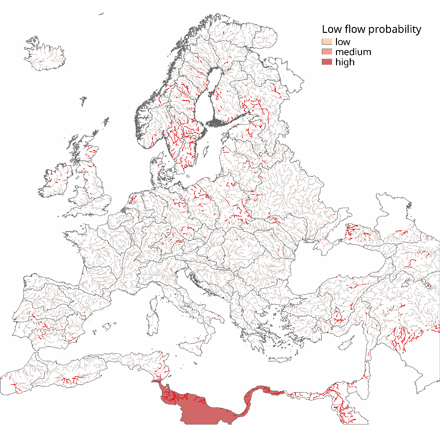
Figure 3: The shaded basins are drawn from the EFAS seasonal forecast made on 1 May for mid-June 2018. They show the low flow probability, from low (light red) to high (dark red) probabilities. Probabilities are given by the portion of the ensemble forecast being below the 10th percentile of the EFAS-WB weekly climatology. Here we show three categories: low (50-75%), medium (75-90%) and high (>90%). The ‘actual’ low flow situation from the EFAS-WB for 11 June (as a proxy for mid-June) is also shown by the red river network
June 2018
Most of the low flows by mid-June were primarily located around southern Sweden and northern Africa (Fig. 3). These were however not picked up very well by the EFAS seasonal outlook produced on 1 May.
July 2018
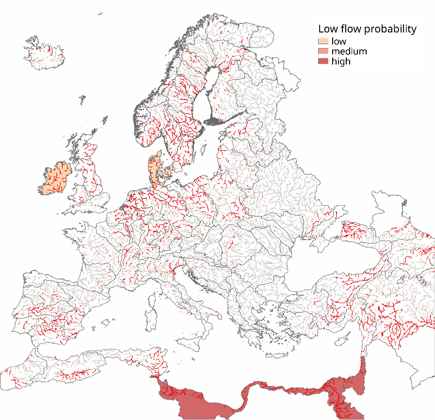
Figure 4: EFAS seasonal forecast made on 1 June for mid-July. The ‘actual’ low flow situation from the EFAS-WB for 11 July (as a proxy for mid-July) is also shown by the red river network
By mid-July, the low flows had extended to most of the British-Irish Isles, larger parts of Sweden and southern Norway, central Europe (around the Rhine, Po and Elbe river basins), the southern Iberian Peninsula, and eastern Europe (East of the Black Sea; Fig. 4). The EFAS seasonal outlook produced on 1 June for mid-July provided early warning of low flows in North Africa, Ireland, and Denmark, but the signal was not well predicted for most regions six weeks ahead.
The low hydrological predictability for July for forecasts issued from EFAS seasonal at the start of June is likely explained when comparing the seasonal meteorological forecasts (SEAS5)3 for temperature and precipitation issued at the start of June (Fig. 5, left) and start of July (Fig. 5, right). The warm and dry anomaly signals that led to reduction in river flows are weaker and shifted eastwards in the earlier June forecast compared to that issued at the start of July.
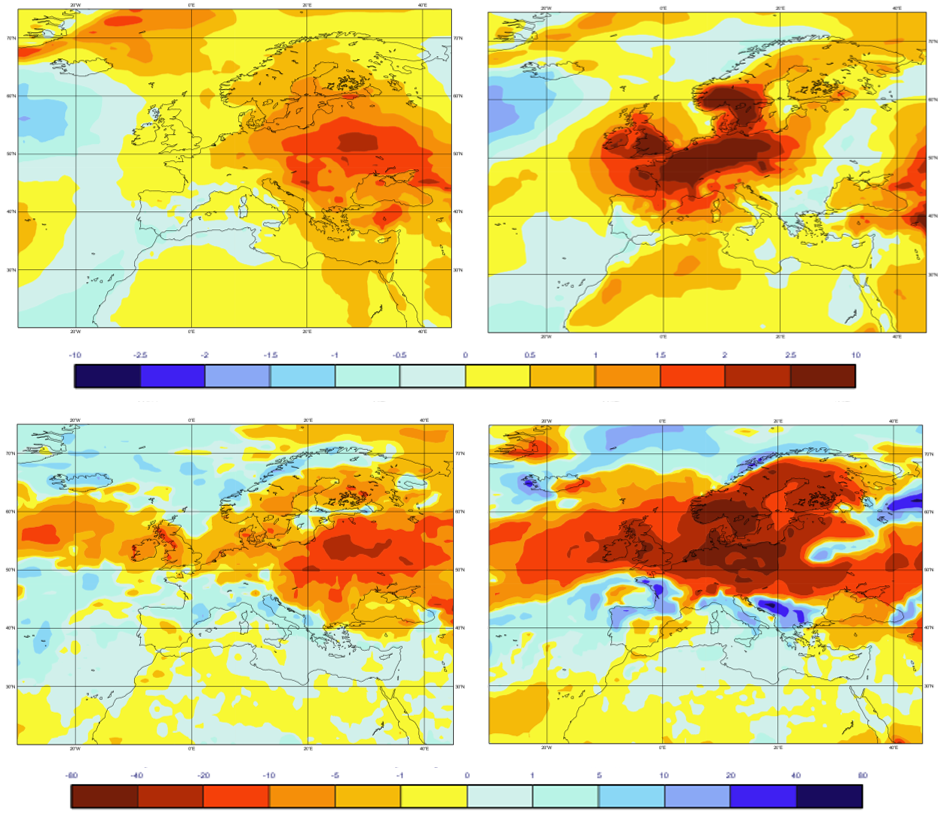
Figure 5: SEAS5 forecast of the 2-metre temperature anomaly (in ˚C; top row) and of the total precipitation anomalous rate of accumulation (in mm/month; bottom row) made on 1 June (left column) and on 1 July (right column) for July
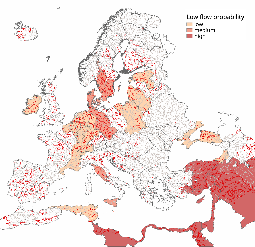
Figure 6: 1 July EFAS seasonal forecast for mid-August. The ‘actual’ low flow situation from the EFAS-WB on 11 August (as a proxy for mid-August) is also shown by the red river network
August 2018
By mid-August, the lows flows reached most of Finland, western Europe (including most of the Iberian Peninsula and France), and regions around the Adriatic Sea (Fig. 6). This was reasonably well predicted by the EFAS seasonal outlook made on 1 July for mid-August (six weeks ahead). The forecast signal was however quite weak (due to the forecast’s inherently growing uncertainty with lead time) and missed selected areas, including most of western Europe.
The performance deficiencies of the EFAS seasonal outlook can here again be partly attributed to the SEAS5 forecast anomalies for August (Fig. 7), weaker and shifted eastwards in the 1 July forecast compared to the 1 August forecast. The missed low flow signal in western Europe could be due to a combination of the wet anomaly predicted for July (Fig. 5, right), followed by the weaker warm and dry anomaly predicted for August by the 1 July forecast (Fig. 7, left) compared to 1 August forecast (Fig. 7, right).
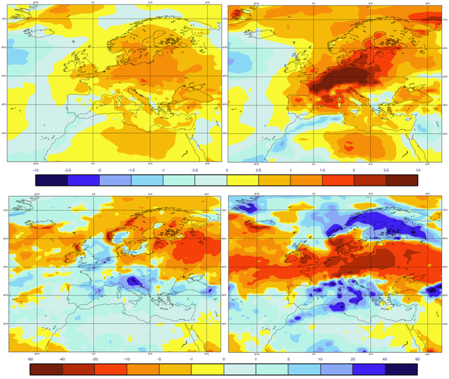
Figure 7: SEAS5 forecast of the 2-metre temperature anomaly (in ˚C; top row) and of the total precipitation anomalous rate of accumulation (in mm/month; bottom row) made on 1 July (left column) and on 1 August (right column) for August.
Looking at the latest EFAS seasonal outlook initialised on 1 August (Fig. 8), it did a pretty good job at capturing the maximum spatial low flow extent of June-July-August, on 24 August, with four weeks lead time.
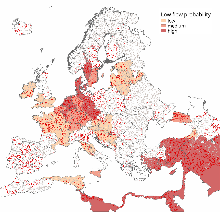
Figure 8: 1 August EFAS seasonal forecast for end of August. The ‘actual’ low flow situation from the EFAS-WB on 24 August (as a proxy for the end of August) is also shown by the red river network
To sum up
Overall, the EFAS seasonal outlook did manage to predict the summer 2018 low flow conditions one month to six weeks ahead in parts of Europe (noticeably the 1 July forecast for mid-August and 1 August forecast for end of August). This could be largely attributed to the dry initial hydrological conditions at the start of July and August, reflected in the river flow forecast through land surface memory. As shown by Arnal et al. (2018), much of the predictability of EFAS seasonal in summer is from the initial hydrological conditions, which seems to be consistent with this case study. The weak anomaly signals in the SEAS5 forecasts made on 1 June (1 July) for July (August) likely contributed to the lack of hydrological predictability in many regions for lead times greater than one month. Looking back at this event and similar ones (e.g. summer 2003 and 2015) in more detail will help us understand the sources of predictability and uncertainty in the EFAS seasonal outlook thus leading to improved forecasting of future events.
Acknowledgments
We thank Christel Prudhomme, Fredrik Wetterhall, Henny van Lanen, Lena Tallaksen, Florian Pappenberger, and Peter Salamon for their helpful feedback on this post.
Neither the European Commission nor ECMWF (European Centre for Medium-Range Weather Forecasts) is responsible for any use that may be made of the Copernicus information or data this publication contains.
Want to know more?
1EFAS is an operational service of Copernicus Emergency Management Service (CEMS) and is run at ECMWF (European Centre for Medium-Range Weather Forecasts). EFAS seasonal outlook is produced operationally at the start of each month and shows the river flow anomaly and its probability of occurrence for the next eight weeks, aggregated over European regions. It is obtained by forcing the LISFLOOD hydrological model with the ECMWF seasonal ensemble meteorological forecasts (SEAS5). The EFAS seasonal outlook is currently only available for registered partners, but we are working towards making this product available to the public in the near future.
2The water balance (EFAS-WB) is a continuous simulation of the LISFLOOD gridded hydrological model (5km resolution) forced with observed meteorological observations.
3The SEAS5 forecasts shown here contain modified Copernicus Climate Change Service (C3S) information 2018.
Arnal, L., Cloke, H. L., Stephens, E., Wetterhall, F., Prudhomme, C., Neumann, J., Krzeminski, B., and Pappenberger, F.: Skilful seasonal forecasts of streamflow over Europe?, Hydrol. Earth Syst. Sci., 22, 2057-2072, https://doi.org/10.5194/hess-22-2057-2018, 2018.
HEPEX blog post: Skilful seasonal forecasts of streamflow over Europe?
0 comments