The Global Flood Awareness System
Triggered by the devastating floods in Elbe and Danube in 2002, the European Commission – Joint Research Centre (JRC) launched in 2003 the development of a European Flood Alert System (EFAS). EFAS is a unique system that is providing a Europe-wide overview on ongoing and forecast river floods up to 10 days in advance. In 2012 it was transferred to ECMWF for the computational run of daily forecasts and the monitoring of its performance.
Based on the experience gained with EFAS and reacting to the increasing need for better preparedness to worldwide hydrological extremes, the JRC has joined forces with the ECMWF, to couple state-of-the art weather forecasts with a hydrological model on global scale. Since July 2011, the Global Flood Awareness System (GloFAS) runs daily a fully hydro-meteorological flood forecasting model, producing ensemble streamflow predictions (ESP) with worldwide coverage and forecast horizon of about 1 month. An important aspect of this global system is that, like EFAS, it is set-up on continental scale and therefore deals with the hydrological processes at the catchment scale – independent of administrative and political boundaries – providing downstream countries with information on upstream river conditions as well as continental and global overviews.
GloFAS is still in its infancy and requires further research and development, calibration of model parameters against discharge observations, and validation of forecasts for observed flood events. Recent research by Alfieri et al. (2013) shows that current ensemble streamflow predictions can enable skillful detection of hazardous events with forecast horizon as long as 1 month in large river basins (see Figure 1).
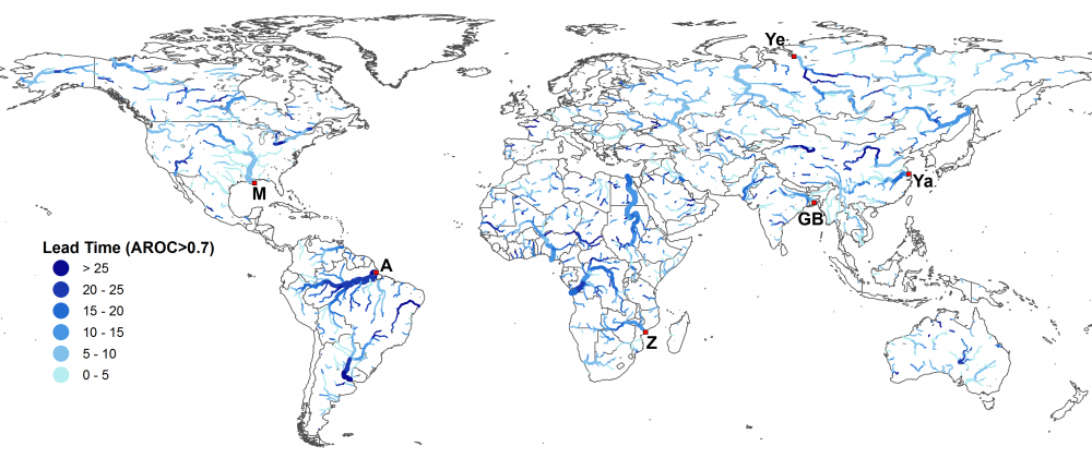
Figure 1: Forecast lead time, in days, for which ESP are skillful (area under ROC curve > 0.7).
The system has already demonstrated its potential in recent catastrophic floods. The severe floods in Pakistan in July-August 2010 were clearly detected by the system as a major flood event. Since the operational setup in July 2011, flood forecasts are produced on daily basis and displayed in a password-protected website. Probabilistic discharge forecasts are compared with three warning threshold maps (namely, medium, high and severe) and flood warnings are derived accordingly. Results are displayed through warning maps and with additional information at selected reporting points.
A more recent example is the series of floods in the South-Eastern Asia (mainly Thailand, Cambodia and Vietnam) in September-October 2011, where persistent heavy rainfalls caused hundreds of victims, induced widespread landslides upstream and submerged vast lowland areas including roads, houses and rice fields. For the lower Mekong River, probabilistic forecasts from the global simulations on 18th September 2011 showed a probability higher than 40% of exceeding the high alert level from 2nd to 4th October, hence 14 days in advance. The following forecasts confirmed these results and became progressively more severe (see Figure 2), with probability to exceed the high alert level at the beginning of October reaching 100% from the forecast of 24th September onwards. Regarding the devastating monsoon flooding in Thailand, the peak flow of the Chao Phraya River was forecast since mid of September 2011, about 10-15 days before the actual peak occurred and the major losses took place.
The potential applications of such a system are not limited to flood forecasting. Water is one of the most precious resources in many regions of the world and improved reservoir management could contribute to reducing water shortages. Furthermore, state-of-the-art hydro-meteorological information up to 15-30 days in advance may be used for optimizing hydropower production, thus contributing to green energy.
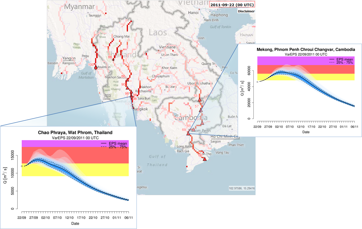
Figure 2: 45-day probabilistic discharge forecasts for the Chao Phraya (Thailand) and the lower Mekong (Cambodia) on Sept. 22nd, 2011. Input rainfall is provided for the first 15 days only.
Alfieri, L., Burek, P., Dutra, E., Krzeminski, B., Muraro, D., Thielen, J. and Pappenberger, F.: GloFAS – global ensemble streamflow forecasting and flood early warning, Hydrol. Earth Syst. Sci., 17(3), 1161–1175, doi:10.5194/hess-17-1161-2013, 2013.
0 comments