We need better topography data for better flood inundation simulation
Contributed by Dai Yamazaki.
In recent years, technical barriers for executing flood inundation simulation are getting lower and lower, thanks to increasing computational power and increasing availability of satellite observation data. Flood inundation models are now being used for flood risk assessment and monitoring, such as making a flood hazard map at any location in the world and forecasting flood hazard in a real-time manner.
The physics equations used in flood inundation models are relatively simple, compared to those of atmospheric models for weather forecasts and climate projections. It is usually adequate to apply only two physics equations: the shallow water equation for momentum conservation and the continuity equation for mass conservation. We can explain most of the surface water dynamics during flood hazard events by using these two governing equations. Thus, the development of the flood inundation model itself is not so difficult.
However, having a good flood inundation model does not always means you can perform a good flood inundation simulation. Even though the physics model is perfect, you need good topography data as a boundary condition of the physics model, because the movement of surface waters are highly dependent on topography. The flow capacity of the river channel is mainly decided by the channel cross-section (i.e. channel depth and width), and the simulation of overbank flow is regulated by very detailed topography in floodplains.
In some countries, we can access high resolution and high accuracy DEMs (Digital Elevation Models) based on either field observations or airborne lidar. However, in many parts of the world, spaceborne DEMs are the only information source for the topography data. Some global satellite DEMs (e.g. SRTM DEM, ASTER GDEM, AW3D-30m DEM) are now freely available, but spaceborne DEMs are affected by various observational errors, which are not negligible for flood inundation simulations.
It is found that the spaceborne DEMs are affected by the four major error components:
- Random speckle noise due to uneven surface reflectance,
- Stripe noise caused by the oscillation of measurement instruments on a spacecraft.,
- Absolute height bias due to the lack of the ground reference points, and
- Surface object bias due to tree canopy or buildings. The maximum amplitude of each error component is sometimes >10m, thus it degrades the accuracy of flood inundation simulations given the magnitude of flood wave is usually <10m.
In order to overcome these limitations in spaceborne DEMs, recently a new global elevation dataset MERIT DEM (Multi-Error-Removed Improved-Terrain DEM) was developed at the University of Tokyo (Yamazaki et al. 2017). The four major error components in the SRTM3 DEM and SW3D-30m DEM are separated and removed by a novel algorithm combining multiple satellite observations and multiple statistical filtering. The topography represented by the MERIT DEM is obviously more realistic compared to the previously available DEMs (Figure 1).
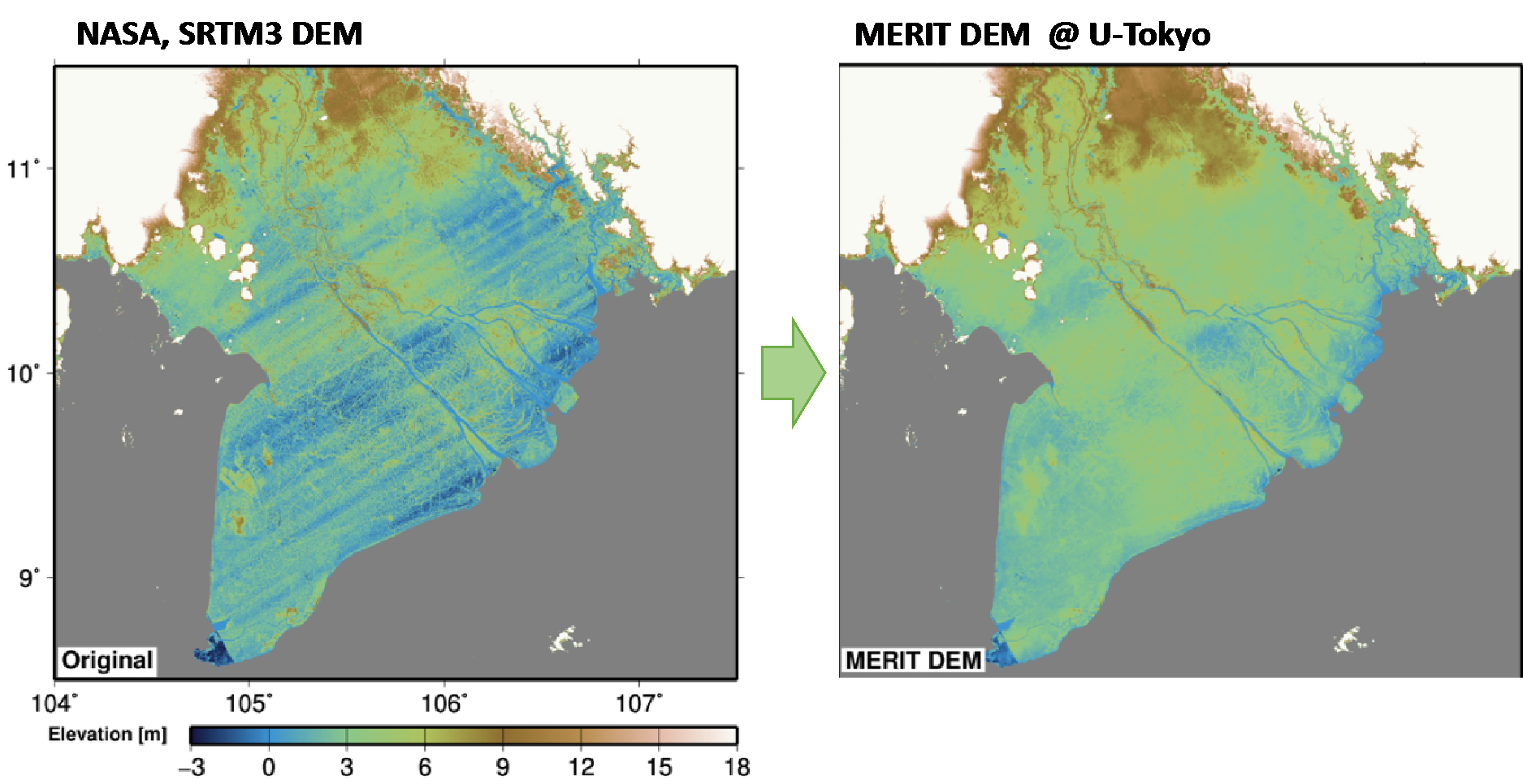
Figure 1: The topography of the Mekong River delta represented in the SRTM3 DEM (NASA) and the MERIT DEM (Yamazaki et al. 2017).
In order to discuss the importance of accurate topography datasets, flood inundation simulations by the CaMa-Flood global hydrodynamic model were performed using both the original and improved elevation datasets. The simulation with the conventional topography datasets (SRTM3 DEM and HydroSHEDS flow direction map) is obviously affected by the errors in the DEM. We can observe the impact of striping artefacts in the simulated flood inundation extent of Tonlé Sap Lake, Cambodia, using the original topography dataset (left panel in Figure 2). While in the simulation using the improved topography data (right panel in Figure 2), the erroneous striping patterns disappeared. Furthermore, because the conventional DEMs are provided in Integer format, the expansion and shrinking of Tonlé Sap Lake was simulated like step-wise. In the simulation with the new topography data, the extent of the Tonlé Sap Lake changed smoothly. These features suggested that we need a better topography data for a better flood inundation simulation.
The newly developed MERIT DEM could be very helpful to improve flood risk assessment especially in areas with limited local topography datasets. However, more detailed topography data is required to further improve flood inundation simulations. Currently, information on under-water bathymetry is not generally available, though river channel depth is a key factor in deciding the channel’s flow capacity and flood inundation extent. The human intervention of surface water dynamics (e.g. dam, levee, canal networks) are not adequately treated in flood inundation models, thus we have to integrate these to topography datasets. The development of comprehensive global hydro-topography datasets is an urgent task in flood risk assessment studies, in addition to the physical flood model development and its applications.
0 comments