A Month of Storms: Ciara, Dennis and Atmospheric Rivers
Contributed by Helen Griffith, Dept of Geography & Environmental Science, University of Reading, UK.
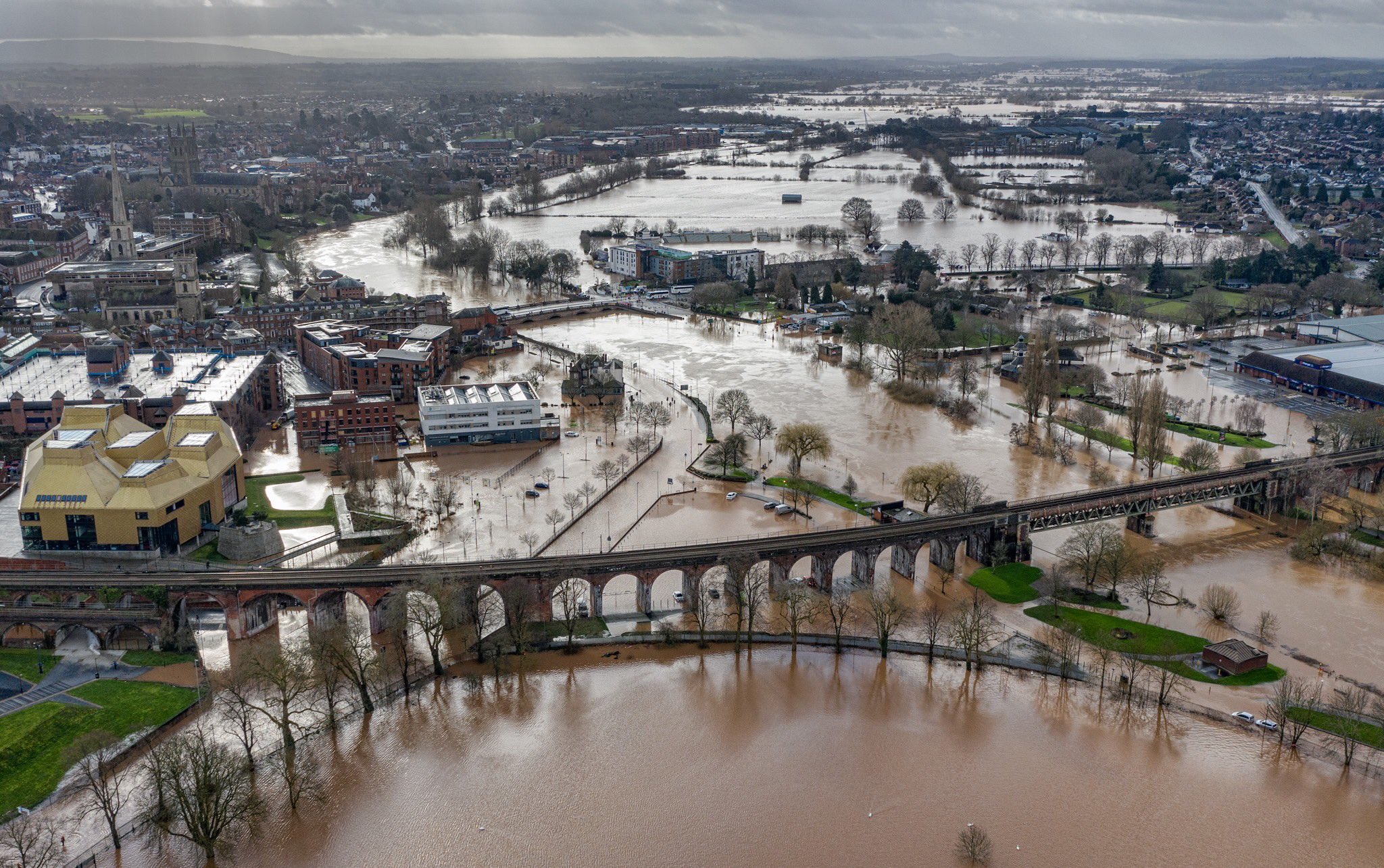
February 2020 has been announced as the wettest February on record for most of the UK[1]. The arrival of Storms Ciara and Dennis led to widespread flooding and the recovery is expected to cost the insurance industry over £225m[2]. Saturated soils combined with additional rainfall mean that, at the time of writing, over 100 flood warnings are still in place across England and Wales and the misery for those affected is far from over. Here we suggest that the impacts of Storms Ciara and Dennis were likely exaggerated by the arrival of coincident atmospheric rivers.
Storm Ciara
Ciara was named by the Met Office on the 5th of February, with winds of 50-60mph and gusts of up to 80mph across coastal regions. In combination with spring tides, some coastal flooding was anticipated. When the storm hit overnight on the 8th of February, gusts of up to 97mph were recorded off the coast of the Isle of Wight and an intense band of rainfall drove river levels to record levels across parts of North Wales, Northern England and the Scottish Borders. There was widespread travel disruption and hundreds of properties were flooded across Northern England and North Wales. It is likely that the combination of extreme winds and intense rainfall was what led to the extent of impacts following Storm Ciara.
Long, narrow regions of intense water vapour transport, known as atmospheric rivers (ARs), are well-known across the mid-latitudes (e.g. Western US and Europe) as a strong control on the amount of rainfall delivered by winter storms. Existing as part of the broad ascending region of warm moist airflow, known as the Warm Conveyor Belt, but much lower down in the atmospheric column, these regions of intense moisture flux can accompany winter storms, such as Ciara (or Desmond in December 2015) in their passage across the Atlantic. When AR storms make landfall, the low-lying moisture flux is forced to rise by coastal topography, often resulting in heavy and persistent rainfall. The UK typically experiences 3-4 of these events each winter, but current climate change projections suggest that they are to get stronger (Lavers et al., 2013).
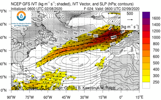
Figure 1: Storm Ciara and its AR as seen in the National Centres for Environmental Prediction (NCEP) Global Forecast System (GFS) weather model[3]; a clear AR can be noted. In combination with a particularly strong jet-stream[4], the result was an exceedingly ‘wet’ storm.
The Following Week
The week following Storm Ciara, those affected had little time to recover before the next storm was named as Dennis, on course to arrive the following weekend (15th). Dennis was not expected to be as severe as Ciara, at least in terms of wind strength, but weather models forecast the presence of another AR (Figure 3). During the week following Ciara, the UK was subject to a number of small storm systems travelling just ahead of Dennis (Figure 2) which only added to increasingly saturated conditions across most of England and Wales.
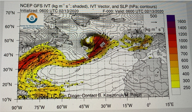
Figure 2: Model output for 13th February. A ‘family’ of extra-tropical cyclones (winter storms) can be noted ahead of Dennis, which is just developing off the eastern United States. The impact of the smaller storms was to add rainfall to already saturated soils across England and Wales.
Storm Dennis
Nearly a month’s worth of rain fell in South Wales Valleys in less than 48hrs as a result of Dennis’ arrival on the 15th of February. This led to the most severe weather warning being issued by the Met Office; a red ‘danger to life’ warning. Amber or yellow warnings for rain remained in place across the rest of England, Wales and Southern Scotland throughout the weekend. Many rivers in southern Wales, the English borders and southern England reached the highest levels ever recorded and, at the time of writing, at least 5 fatalities had been reported. The exact number of flooded properties is not yet clear, but it is likely to be upwards of 500, many of whom were in a similar position the week before.
BREAKING: we now have the most flood warnings and alerts in force (594) in England than any other day on record. Stay safe and updated here https://t.co/K5GUW3z87V pic.twitter.com/0IEdWBAOpi
— John Curtin (@johncurtinEA) February 16, 2020
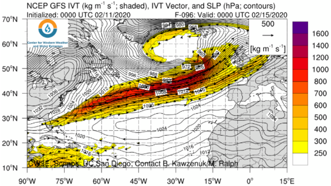
Figure 3: NCEP GFS weather model prior to the arrival of Dennis. The presence of another AR can be clearly seen. This AR was responsible for the persistent rainfall across the weekend of the 15th of February.
Implications
Currently in the UK, nearly two weeks after the arrival of Storm Dennis, we have over 100 flood warnings still in place across England and Wales, and for a third weekend in a row, a bout of heavy rainfall has added to the misery of those affected (22nd February). Inspection of the NCEP GFS forecasts visualised by Professor Ralph’s group suggest that this rainfall was also attributable to, an albeit weaker, atmospheric river event. The widespread floods have affected some of the poorest communities in the Europe[5], many of whom have experienced similar such events within the past decade (e.g. November 2012 and December 2015). Even at the time of writing, continued rainfall upon saturated catchments and delayed responses within some of the largest river basins means that the risk of rising river levels and surface water flooding continue (e.g. the River Severn).
As scientists and forecasters, our attention is drawn to the meteorological conditions surrounding these storms, as the severity of impacts will depend both on our forecasting accuracy and the capacity of those to react. Although it is acknowledged that the strength of Storms Ciara and Dennis were exceptional[6], we suggest that the arrival of coincident AR moisture was likely responsible for the intense and sustained rainfall totals and the impacts that followed. Combined with the storms’ arrival less than a week apart, local catchments conditions across large areas of the UK will have been primed for a particularly strong hydrological response.
The synoptic scale of ARs may be able to help in the predictability of hydrological extremes (Lavers et al., 2016) with such ideas currently on trial at the Flood Forecasting Centre, which is a partnership between the UK Met Office and Environment Agency. However, gaps remain regarding our knowledge of particular properties of AR storms, and why some ARs appear to generate stronger hydrological responses than others. An idea explored in the United States has been the development of an AR categorisation scale (similar to those used in hurricane analysis) ranking ARs from 1 through 5 (Ralph et al., 2019) according to their likely impacts. Professor Ralph has recently been quoted as labelling Dennis “likely a 5” (the most impactful AR) [7], and with a meeting scheduled at the European Centre for Medium-Range Weather Forecasts (ECMWF) later next month, there is certainly space and interest in extending the science of ARs into UK based forecasting. Ongoing work at the University of Reading and ECMWF is hoping to fill this gap.
Further Reading
Lavers, D. A. et al. (2013) ‘Future changes in atmospheric rivers and their implications for winter flooding in Britain’, Environmental Research Letters, 8(3). doi: 10.1088/1748-9326/8/3/034010.
Lavers, D. A. et al. (2016) ‘ECMWF Extreme Forecast Index for water vapor transport: A forecast tool for atmospheric rivers and extreme precipitation’, Geophys. Res. Lett., 43(11), pp. 852–858.
Ralph, F. M. et al. (2019) ‘A scale to characterize the strength and impacts of atmospheric rivers’, Bulletin of the American Meteorological Society, 100(2), pp. 269–289. doi: 10.1175/BAMS-D-18-0023.1.
- https://www.metoffice.gov.uk/about-us/press-office/news/weather-and-climate/2020/2020-winter-february-stats ↑
- https://www.theguardian.com/business/2020/feb/20/storm-dennis-damage-could-cost-insurance-companies-225m ↑
- http://www.esrl.noaa.gov/psd/arportal/ar_forecasts/index.htmlhttps://cw3e.ucsd.edu/iwv-and-ivt-forecasts/ ↑
- https://www.washingtonpost.com/weather/2020/02/06/hurricane-force-storm-drag-atmospheric-river-europe-while-jet-stream-propels-trans-atlantic-flights-speed-sound/ ↑
- https://www.theguardian.com/business/2019/dec/10/number-of-europes-poorest-regions-in-uk-more-than-doubles ↑
- https://www.telegraph.co.uk/news/2020/02/09/storm-ciara-hits-britain-mph-wind-rain-travel/ ↑
- https://www.ft.com/content/440f4bb6-5276-11ea-8841-482eed0038b1 ↑
0 comments