Balkans’ worst floods for more than 100 years
Contributed by Jutta Thielen, A. Annunziato, I. Andredakis, N. McCormick, M. Kalas, X. Kechagioglou, J. Kucera, D. Muraro, P. Probst, P. Salamon, and V. Thiemig.
![]() After weeks of persistent wet conditions, the exceptionally intense rainfall from 13th May 2014 led to disastrous and widespread flooding in the Balkan Peninsula in south-east Europe, mainly in Bosnia-Herzegovina and Serbia, with flooding also reported in Croatia, southern Poland, Slovakia, and the Czech Republic.
After weeks of persistent wet conditions, the exceptionally intense rainfall from 13th May 2014 led to disastrous and widespread flooding in the Balkan Peninsula in south-east Europe, mainly in Bosnia-Herzegovina and Serbia, with flooding also reported in Croatia, southern Poland, Slovakia, and the Czech Republic.
Officials estimate that three months’ worth of rain had fallen in only a few days, producing the worst floods since rainfall measurements began 120 years ago.
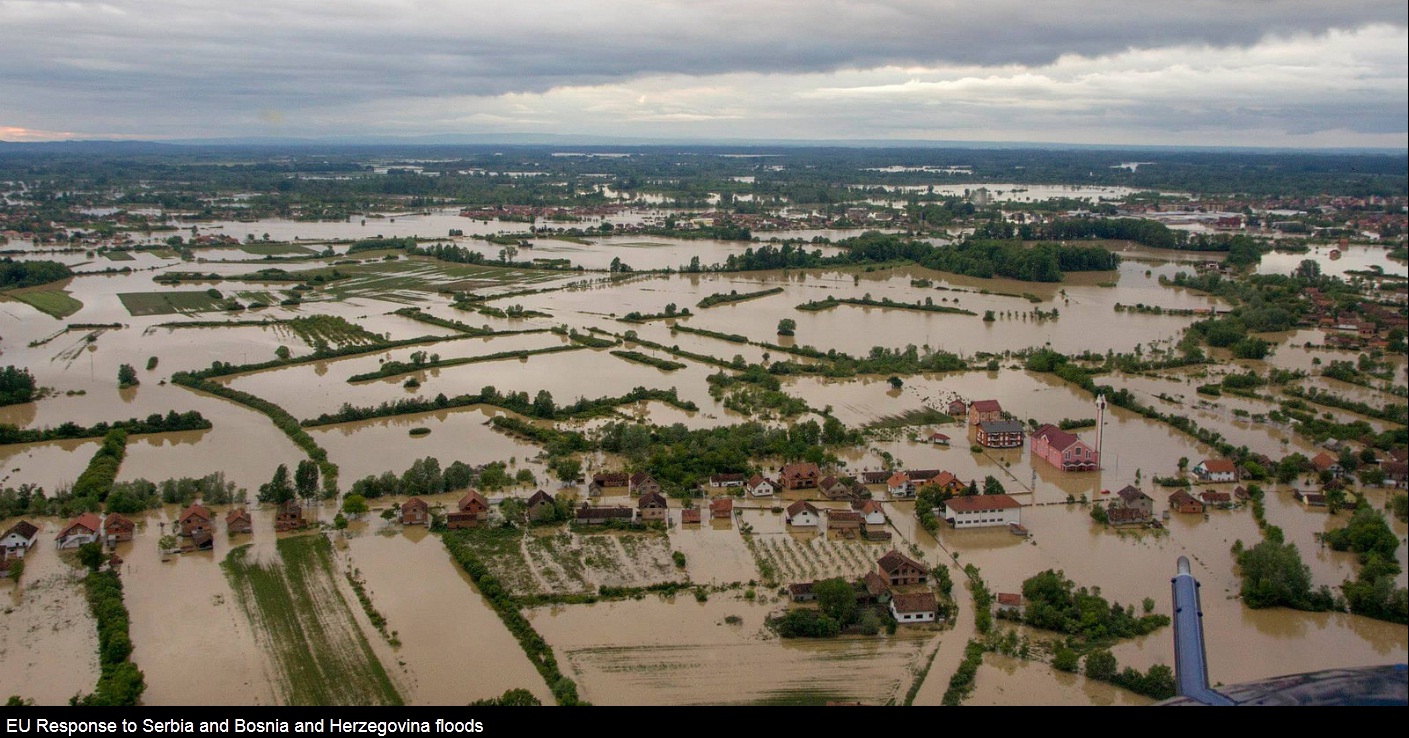
Pictures from a Slovenian helicopter crew as they provide assistance in Bosnia and Herzegovina. Photos direct from the field as EU Civil Protection experts coordinate with their Serbian and Bosnian colleagues in responding to the devastating floods. ec.europa.eu/echo/news/2014/20140516_en.htm Photo credit: EC/ECHO/EEAS/EU Delegation BiH – 19 May 2014
Media reports as on 21st May, report the estimated death-toll due to the flooding in Serbia and Bosnia to range from 35 to 40 people, with more victims expected to be found as the waters recede. Also in Croatia, the Czech Republic, Slovakia and Poland fatalities were reported. More than a million inhabitants are estimated to be affected by the flooding.
In Bosnia, the country’s foreign minister has been quoted in the media as saying that around a million people are without clean water, while more than 100,000 houses and other buildings are no longer usable, and the road infrastructure is badly damaged. It is estimated that as many as 500,000 people had been evacuated or left their homes, with north-eastern Bosnia especially badly affected, with houses, roads and rail lines submerged. About 2,000 landslides caused by the torrential rain have been reported, some on minefields left over from Bosnia’s 1992-95 war, and official sources are quoted as saying that all mine warning signs have been moved.
In Serbia, at least 25,000 people were evacuated, with many more believed to have fled the flooding, it was reported on Monday 19th May. The town of Obrenovac, which houses the country’s largest power plant, was ordered to be evacuated on Monday, while evacuation orders were also made for 11 villages along the River Sava, ahead of an expected new flood wave. Also in Croatia, where heavy floods hit the eastern part of the country, it is reported that two people have died and at least 15,000 needed to leave their homes.
On European level, the disaster management systems have been working well in support of the countries battling the flooding:
- Both Bosnia Herzegovina and Serbia activated the European Community Mechanism, coordinated by the European Response Coordination Centre (ERCC), in the evening of 15th May. Already alerted by the European Flood Awareness System (EFAS) since 11th May, the ERCC coordinated the assistance of 14 countries within less than one and a half days. More countries have been assisted since (see here and here).
- The European Flood Awareness System (EFAS) was developed by the JRC and other research institutes to provide European overviews of ongoing and upcoming floods specifically to experts in the National hydrological services and the European Response Coordination Centre (ERCC). EFAS, now part of the Copernicus Emergency Management Service (EMS) and outsourced to Member States, started providing notifications of severe flooding conditions as early as from 11th May onwards first for Bulgaria, Romania and Serbia, and then to the other countries affected. More information about EFAS can be found here.
- The Copernicus EMS Rush Mode Mapping has provided flood extent maps of the affected areas. It was triggered by the ERCC on 16th May, first for Bosnia-Herzegovina and then Serbia, followed on 17th May by a request from Croatia. The first post-disaster map with flood delineation was delivered on 18th May. Other reference maps and flood delineation maps were delivered during subsequent days and they are available here and here.
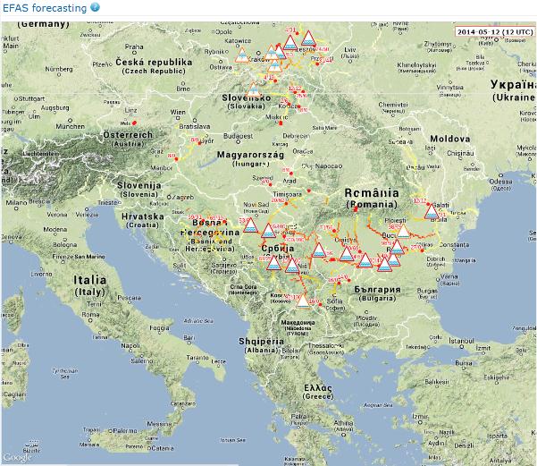
In case of high probability of upcoming floods, EFAS sends notifications to national hydrological authorities which are part of the EFAS network. Here, a screenshot from the European flood Awareness System (EFAS) based on 2014-05-12 12:00 forecast is shown, highlighting locations for which EFAS notifications have been sent. Bosnia-Herzegovina is currently not an EFAS partner. All information is shared also with the European Emergency Response Coordination Centre.
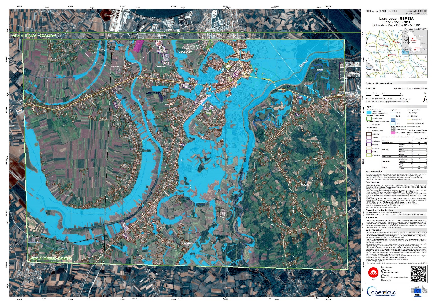
Flood delineation map for Serbia, Location LAZAREVAC (source: EMS – Mapping service).
June 2, 2014 at 00:09
I volunteered with the Standby Task Force (http://blog.standbytaskforce.com/) to help with situation awareness by classifying images and texts from social media for this event. I recommend it.
Anyone can do it, you don’t have to be an expert. For example, from my home in Australia, in an hour I was flashed about 800 photos of flooding in the region and tagged them 1. No damage, 2. Mild damage and 3. Severe damage. Other online experts (in Norway, South America, etc etc) then put the photos on a map. You can also classify twitter tweets (e.g. 1. Reporting damage 2. Asking for help …).
The Standby Task Force calls for volunteers every three months or so.