Floods: nothing we can do against nature?
I heard a tourist visiting the Calgary area saying on the Canadian TV that “against nature, we can do nothing”, in reference to the recent floods in the province of Alberta, in Canada. In flood prevention, forecasting and protection, are we actually at the mercy of nature?
The province of Alberta has faced what is expected to be one of the “worst flooding in decades”, with hundreds of thousands of residents evacuated following severe flooding.
According to the Streamflow Advisory Overview for Alberta (Flood Warning Update Issued at 6:20 PM – June 23, 2013, by River Forecast Centre), “from Wednesday morning [June 19] to Saturday morning [June 22], an intense low pressure system brought between 80 to 280 mm of precipitation to an area between Waterton Park and Banff; local amounts of up to 340 mm at stations in the upper Sheep, Elbow and Bow River basins have been recorded”.
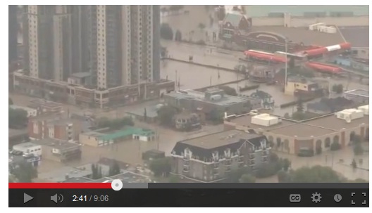
Aerial views of the extent of the flooding areas are provided here by Climate State or here by Global News. Interesting are also the before and after photos provided by CBC News:
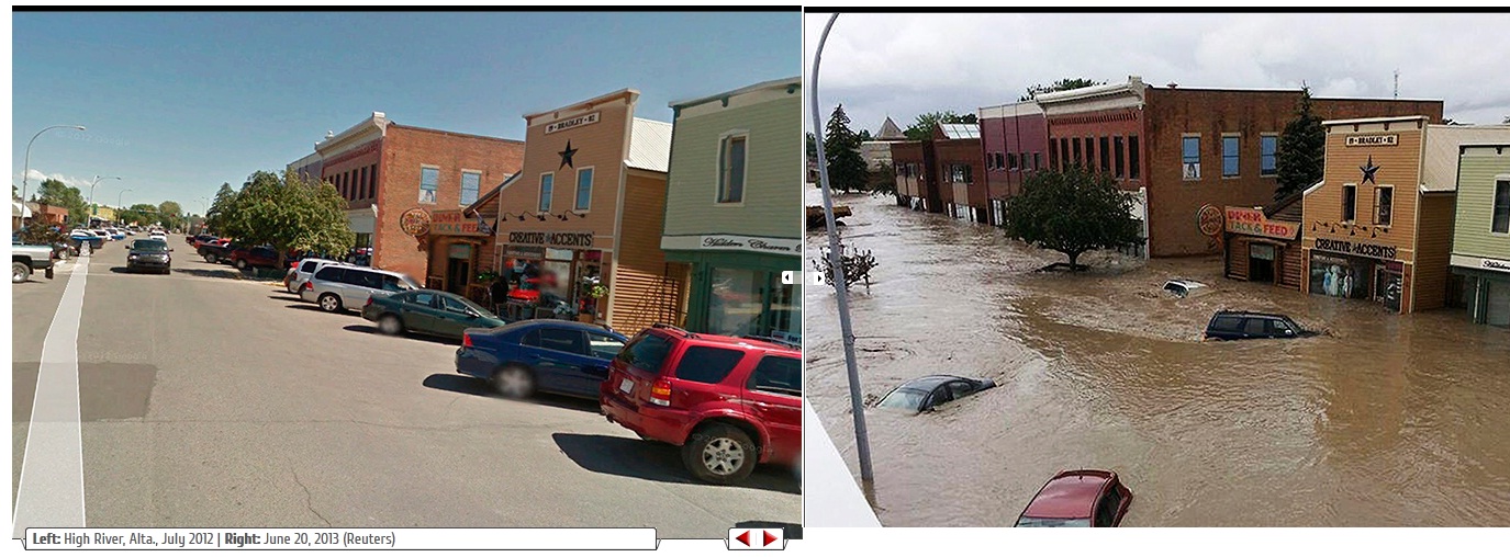
Source: CBC News
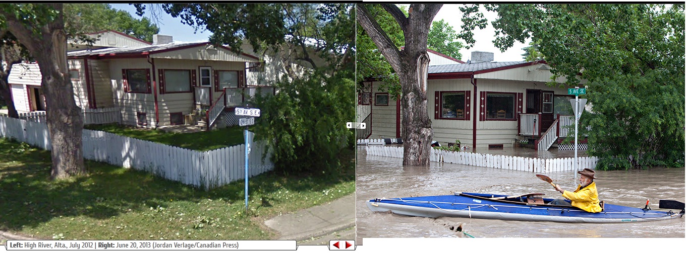
Source: CBC News
Archived warnings for Alberta are available from the Environment and sustainable development website of the Alberta Government. The June 20, 2013 6:45 AM Flood Warning for Alberta, the highest level of warning, says: “Rising stream levels will result in flooding of areas adjacent to the streams affected. Anyone situated close to the river should take appropriate measures to avoid flood damage.”
An overview of flood warnings for the Bow river, the river running through the city of Calgary, can be seen below. They illustrate how the alerts increased fast in intensity, from High streamflow advisory up to Flood warning, in a short time period.
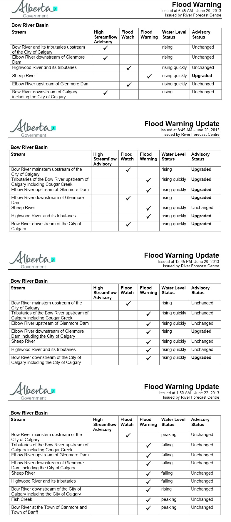
Source: Alberta Government
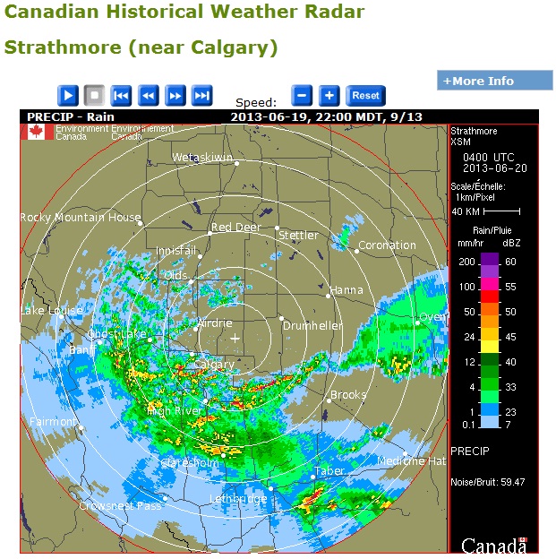
The critical alert for overland flow of the Albert Emergency Alert issued on Fri Jun 21 11:58 AM states that the Bow river basin “has received 250 millimeters of precipitation since Wednesday morning” [June 19]. Radar weather data for the period are available from the National Climate Data and Information Archive:
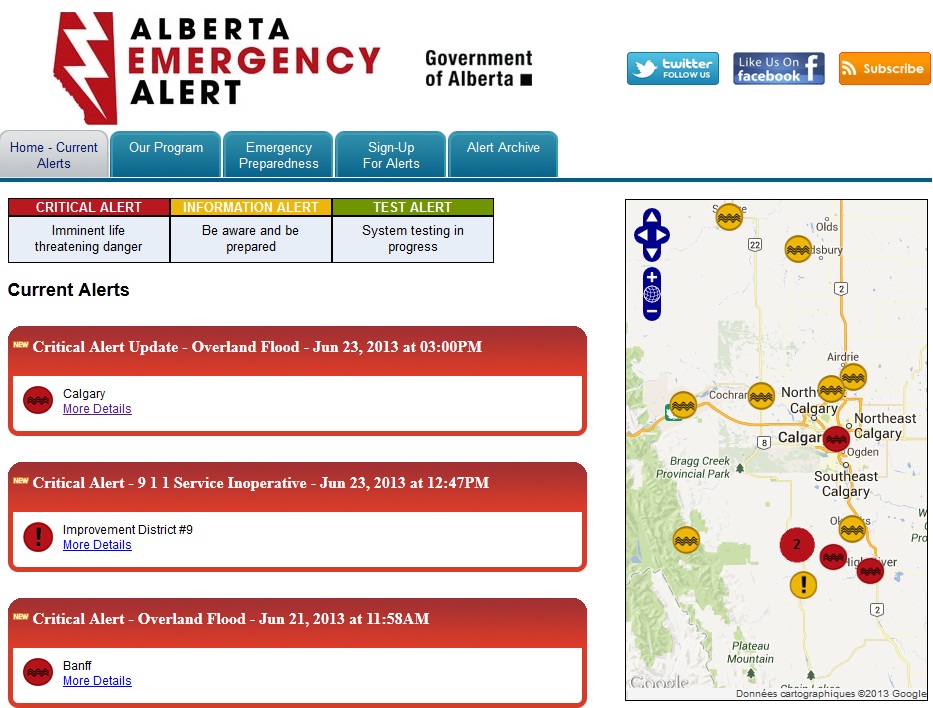
Critical alerts in the province of Alberta were still issued by the Albert emergency alert on June 23rd. Their archive of alerts is also an interesting source of information. It shows, for instance, an extremely busy day on Thursday June 20th, with 29 alerts issued between Jun 20, 2013 at 02:42AM and Jun 20, 2013 at 11:49PM. They included alerts for high water level, flash floods, dam overflow, and overland floods.
Source: Albert emergency alert
Portions of several communities were under mandatory evacuation in the area of Calgary. The Calgary city news blog presents an interesting archive of flood information from the City news’s State of Local Emergency, illustrating the history of evacuation orders, road closures, water conditions and river levels. This is a nice initiative to praise those that work hard in these critical periods to guarantee public safety, while it might also be useful when the time will come to learn lessons from the flood event.
Crisis management can be specially demanding when it comes to flash floods. Near Real-Time Water Level Information provided by the Wateroffice shows a quick rising of water levels (see below) measured at stations in Calgary and surroundings. They highlight, as it was also the case of the recent flood event in Southwest France, the challenges on discharge and water level data acquisition and, consequently, on the development of robust data assimilation procedures in hydrological forecasting.
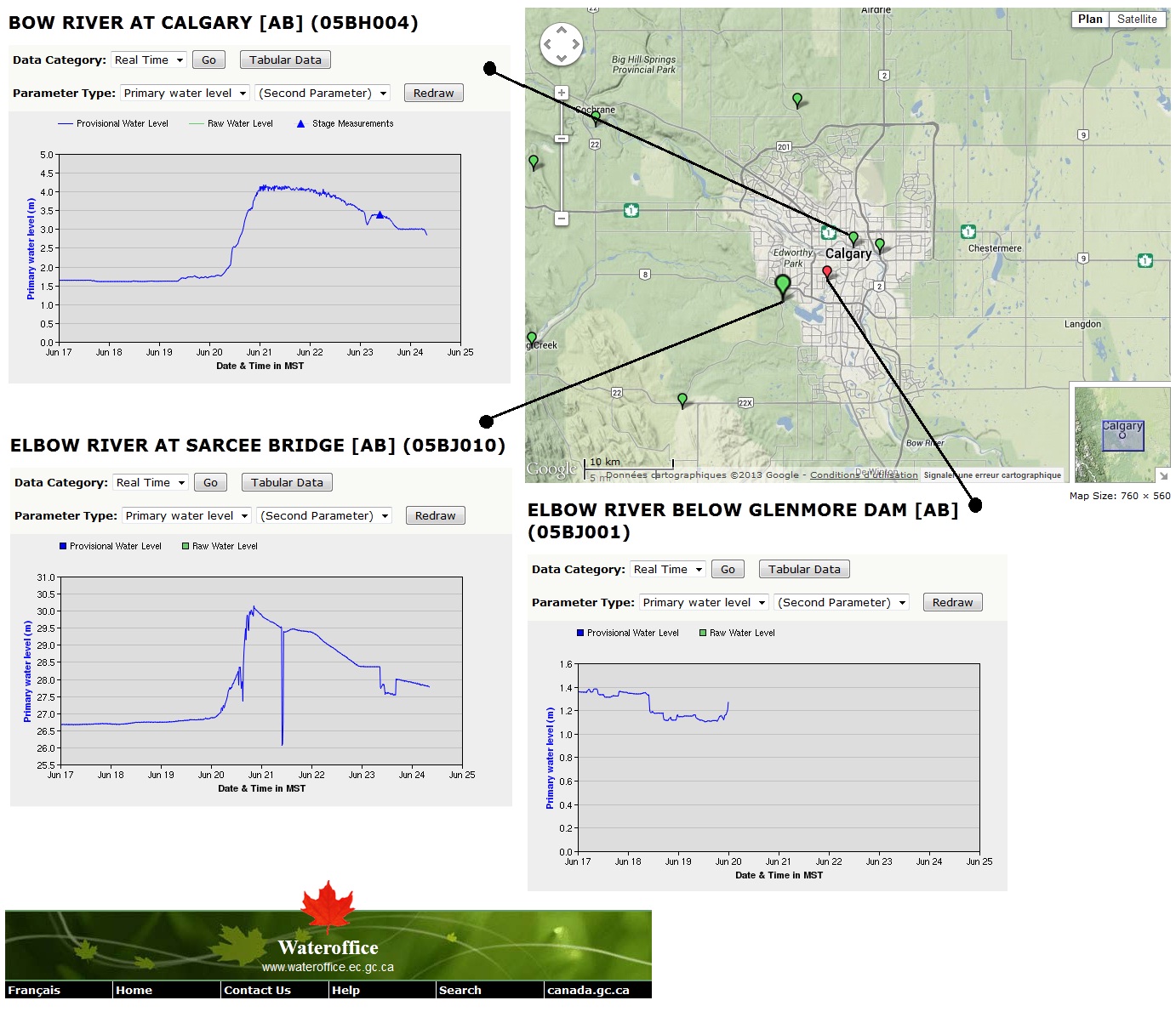
Source: Wateroffice
What HEPEX can learn from nature
All the information above concerns observations linked to the flood event. The archives of data and flood warnings available through websites of the Canadian government are interesting pieces of information for analyses in view of contributing to a better understanding of several issues on flood forecasting, as, for instance, the role of flood forecast interpretation and alert communication in disaster management.
Hopefully we will soon have here also in the HEPEX website some information about forecasts and ensemble predictions for this event. If you have any contributions to share, feel free to post a comment or a follow-up blog.
UPDATE: This update is proposed by Fredrik Wetterhall from ECMWF. It shows some screenshots of GloFAS forecasts for the Bow river.
– GloFAS forecasts of the Bow River
The flooding in Bow River could be detected as early as in the beginning of June, although not with the exact timing (see figure below). The severity of the flooding was underestimated by the mean of the ensembles, but it was captured by some ensemble members.
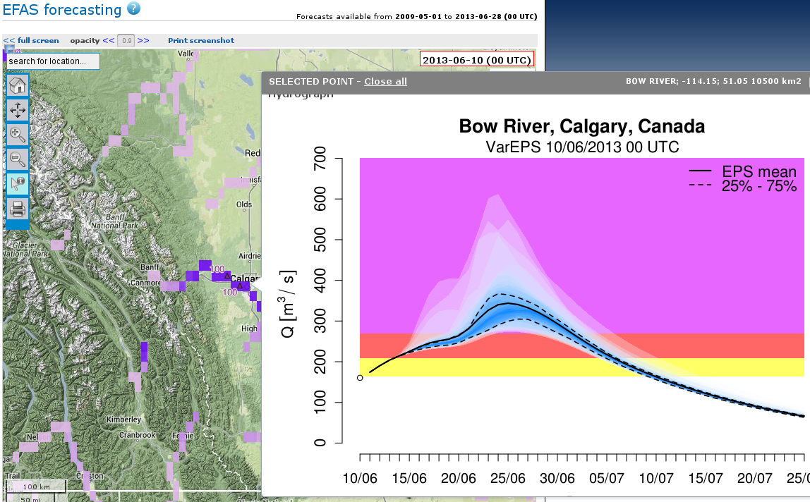
GloFAS forecast of Bow River on the 10 June 2013.
Just before the event, GloFAS did have a strong signal, albeit the timing was somewhat delayed regarding the onset of the flooding (see figure below). The severity of the event is still underestimated, however the system clearly indicates a very severe event in all ensemble members.

GloFAS forecast of the Bow River on 19 June 2013.
July 3, 2013 at 14:50
We updated the post with illustrations of the ensemble forecasts from the GloFAS [1] system for the Bow river. Thanks Fredrik Wetterhall (ECMWF) for the figures.
[1] Alfieri, L., Burek, P., Dutra, E., Krzeminski, B., Muraro, D., Thielen, J., Pappenberger, F. (2013) GloFAS – global ensemble streamflow forecasting and flood early warning. Hydrol. Earth Syst. Sci., 17, 1161-1175.
July 4, 2013 at 07:05
Nice posting. The rapidity of the upgrades during the forecasting in the early hours of June 20 illustrates that during such events, operational forecast entities are often ‘nowcasting’ as much as forecasting. The rising rivers stage and recorded precipitation drive the prediction of flooding and the upgraded warnings more so than the projection of future precipitation combined with lower, earlier stages. Deterministic precipitation forecasts are often conservative and fail to verify for the extremes that are observed, especially at long lead times. I think the contrast of the operational capacity with hands-off GLOFAS results, which may be imprecise in some regards (timing, magnitude) but convey substantial flood risk at longer lead times, suggests that there is currently still a great potential for operational centers to leverage the work being done on more objective, ensemble-based approaches.
July 8, 2013 at 18:24
Updated news on the events starts to comment on the forecast of these floods. Under the title “Alberta must do a ‘much better job of forecasting’ after failing to sound flood alarm early”, the Calgary Herald Newspaper [1] publishes that “Alberta’s river forecasters knew two days in advance that heavy rains would likely hit” the area. While acknowledging the accurate of these forecasts, they raise questions about a more efficient form of communication between forecasters and stakeholders (municipalities) responsible for warning the population.
After the event has happened it is probably easier to talk about what could have been done given the forecasts, but how prepared are we all (forecasters and users) to accept false alarms in exchange for early warnings?
[1] http://www.calgaryherald.com/news/alberta/Alberta+must+much+better+forecasting+after+failing+sound+flood+alarm+early/8595081/story.html