Numerical simulation of 2010 Pakistan Flood in the Kabul River basin using lagged ensemble rainfall forecasting
Contributed by Tomoki Ushiyama and Takahiro Sayama
In 2010, heavy monsoon rains in the Khyber Pakhtunkhwa, Sindh, Punjab and Balochistan regions of Pakistan brought extreme flooding to the Indus River basin and left approximately one-fifth of Pakistan’s total land area (nearly 800,000 square kilometers) underwater. The floods impacted about 20 million people through the destruction of property, livelihood and infrastructure, and nearly 2,000 lost their lives.
In this experimental study, we illustrate how lagged ensemble forecasting of rainfall and streamflow might have been useful to support advance warning for 2010 Pakistan flood in the Kabul River basin, a tributary of the Indus River.
Lagged ensemble forecasting of rainfall and rainfall-runoff-inundation (RRI) forecasting was applied to the devastating flood in the Kabul River basin, the first strike of the 2010 Pakistan flood. The forecasts were performed by using the Global Forecast System of the U.S. NOAA National Centers for Environmental Prediction (NCEP-GFS), which are updated four times daily.
Dynamical downscaling was applied to the forecasts using the Weather Research and Forecasting (WRF), a regional model. The results were verified by comparing the rain gauge-corrected precipitation analysis, the Global Satellite Mapping of Precipitation (GSMaP) product, and the observed indicator of an inundation map based on MODIS satellite data.
GFS predicted a sign of heavy rainfall in northern Pakistan four days ahead of the onset. However, most of the forecasts predicted it in wrong places, and only those performed after the rainfall onset predicted it in the accurate location. Downscaling corrected the locations of the misplaced GFS forecasts and also underestimated or overestimated rainfall amounts derived from GFS. Finally, downscaled forecasts predicted a reliable amount of rainfall in the Kabul River basin one day ahead of the rainfall onset, and predicted a high probability of heavy rainfall three days ahead.
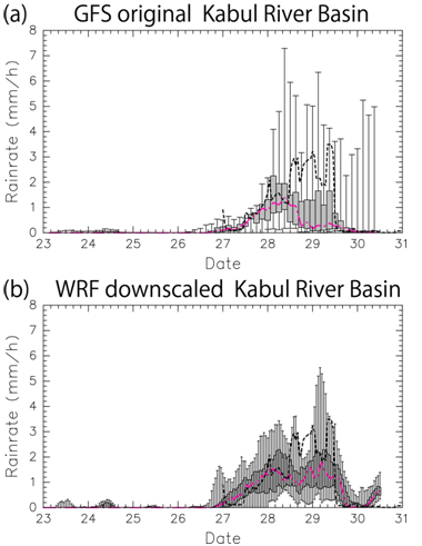
Fig. 1 Probability distribution of average rainrates in the Kabul River basin by (a) GFS original forecasts, and (b) downscaled forecasts. The grey boxes show 25 to 75 percentile, and bars show minimum to maximum number. Dot-broken pink lines and the bold broken lines in both panels are the median and GSMaP rainfall corrected by the ground raingauge, respectively.
Lagged ensemble forecasts of discharge and inundation distribution based on GFS rainfall predicted a small probability of the actual discharge and inundation distribution, but with low reliability. The reliability substantially improved when downscaled rainfall was used. The reliability of the flood alert system combining NCEP GFS, dynamical downscaling by WRF, and the RRI model was found to be acceptable in this study.

Fig. 2 Probability distribution simulated by the RRI model based on downscaled rainfall. The left panels show probability distributions in discharge at the outlet of the Kabul River basin, calculated from lagged ensemble forecasts composed by 13 runs in three time periods: (a) 00 UTC 23 to 00 UTC 26, (b) 00 UTC 24 to 00 UTC 27, and (c) 00 UTC 25 to 00 UTC 28. The color shading shows accumulated probability density with higher probabilities in warm colors. The black line in each panel is the ensemble mean, and the green line is forecasted by corrected GSMaP rainfall. The right panels (d-f) are predicted inundation probability distribution correspond to the three time periods (a-c). The location is the Peshawar Valley near the outlet of the Kabul River basin. The color shading indicates the probability of inundation depth over 1 meter. The black line indicates the inundation map by the observed indicator from MODIS satellite.
The full study can be found here: Ushiyama, Tomoki, Takahiro Sayama, Yuya Tatebe, Susumu Fujioka, Kazuhiko Fukami, 2014: Numerical Simulation of 2010 Pakistan Flood in the Kabul River Basin by Using Lagged Ensemble Rainfall Forecasting. J. Hydrometeor, 15, 193–211.
0 comments