Risk Communication for Cyclone Early Warning – Do people get the message, and understand what it means for them?
Contributed by Bapon Fakhruddin, Senior DRR and Climate Resilience Specialist, Tonkin+Taylor & Co-chair of the Risk Interpretation and Application of IRDR/ICSU
Every year, New Zealand is impacted by ex-tropical cyclones (ETCs) – typically, one ETC makes landfall per year, between the months of November and April. As tropical cyclones approach New Zealand, they begin to lose their strength and undergo extratropical transition (ETT). Some of these weather systems are as large as New Zealand’s North Island when considering the full diameter of the storm, and ETCs can still induce heavy rainfall as well as strong mean winds and wind gusts, coupled with an increased forward motion, making them just as much of a hazard as tropical systems. ETCs have impacted New Zealand in the past (Cyclone Cook, Pam, Victor, Drena, Fergus, etc.) and have the potential to cause flooding and coastal infrastructure damage, generate primary and secondary wind damage to vegetation, and higher-than-normal wave heights and coastal storm surges. The recent Cyclone Cook impacted many regions and devastated peoples’ livelihoods and properties (e.g. heavy rain and high winds in Bay of Plenty, Gisborne and Hawke’s Bay caused flooding, landslips, fallen trees and widespread power outages).
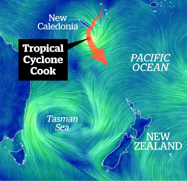
Figure 1. Cyclone Cook approaching New Zealand. Image via NZ Herald.
Producing and Communicating Coastal Inundation Forecasts
Early warning is a key element of disaster risk reduction. It has long been recognized that if society could have advanced information on weather, the adverse effects associated with it could be minimized. Coastal inundation associated with tropical and extra tropical cyclones has a long history of causing death and destruction along our coastlines—and the threat has never been greater. It is imperative that the ever-increasing coastal population understands cyclone risk, particularly related to coastal inundation and storm surge.
Advances in meteorological, hydrological and engineering sciences are fast generating a range of new methodologies for forecasting weather and flood events, including ensemble prediction systems (EPS) and new hydrological or hydrodynamic models. However, many of these advanced prediction systems have not yet been incorporated into operational forecast systems. Consequently, operational forecasts have not yet been integrated into decision making processes in order to reduce disaster risks. In the real world, it has been observed that people do not always notice warnings, or are unable to understand the meaning of probabilistic forecasts well enough to consider themselves at risk. This provides a call to action for our Met Service and Civil Defence research and operations program to develop and implement new coastal inundation mitigation strategies.
Communication of storm coastal inundation is closely tied to how such forecasts are generated and the accuracy of the scientific data they are based on. For example, tropical cyclone forecasts issued by the Met Service have lots of uncertainty. To generate coastal inundation information requires the integration of a cyclone model, storm surge model, wave model and hydrodynamic or river model. It is obvious that when linking a number of models, the level of uncertainty will be very high. At the same time, cyclones change path very frequently and the model needs to have the capacity to generate information in short intervals so that forecast information can reach people living within a few kilometers of the coast. While cyclone track forecasting continues to improve, the mean position errors for tropical cyclones in the area near the South Pacific (160ᵒ East to 120ᵒ West, 25ᵒ South to 40ᵒ South – this area is covered by the Tropical Cyclone Warning Center (TCWC) Wellington, operating within the Meteorological Service of New Zealand Ltd, or MetService) during 2014/15 and 2015/16 cyclone season were 73 km and 93 km respectively, for 24 hours lead time. The longer the lead time, the larger the uncertainties in the track forecasts. Figure 2 shows the cyclone forecast track error (based on ECMWF forecasts 2010-2016) with lead time.
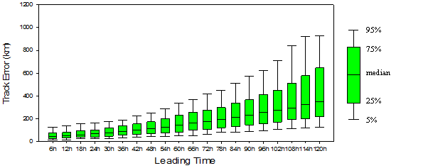
Figure 2: Tropical Cyclone track errors in the ECMWF forecasts (2010-2016). The bars at the top (bottom) of the lines signal the 95th (5th) percentile of track errors. The upper (lower) bounds of the quadrate boxes signal the 75th (25th) percentile of track errors. The bars inside the boxes are the median track errors.
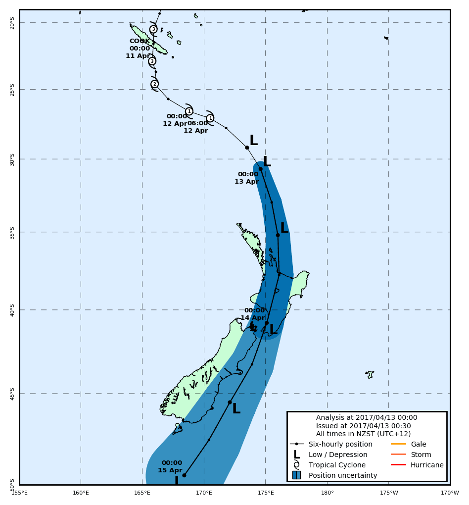
Figure 3. Cyclone COOK Cone of Uncertainty forecast by MetService
A major conundrum in weather messaging is how to communicate forecast uncertainty. While opinions are mixed, there is consensus within the weather enterprise that the level of certainty should be communicated as part of forecasts. For example, the cone of uncertainty released by TCWC based on past track error is probably the most recognized uncertainty graphic, certainly in TC-prone areas (See Figure 3), but often, critiqued, actual testing of its interpretation and use by stakeholders is scarce.
Geographers at the University of Alabama have been testing alternative TC warning graphics with the public, and results indicate preference for a Color Probability Cone that is a revised version of one issued by the Australia Bureau of Meteorology (See Figure 4).
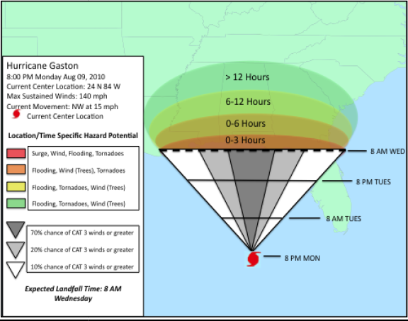
Figure 4. Example of color probability cone and inland hazards for community understanding. The inland hazards are outlined in color and expected times for experiencing those specific hazards are included in the colored zone (Radford, 2012, thesis document)
Significant research efforts have focused on understanding how people make evacuation decisions including the important effects of past experience. Research shows that before deciding to take a disruptive and often expensive action such as evacuation, people must understand the forecast, believe it applies to them and, most importantly, feel that they and/or their loved ones are at risk. However, common practice has been to prepare and release forecast messages without adequately understanding how they are received, understood, and interpreted.
For any new forecasts product (e.g. coastal inundation), there will at first be a lack of communication of the warning to the affected people, and interpretation or internalization of the information for decision-making and response. In order to make a good decision, the capacity to generate coastal inundation forecasts with sufficient lead-time and an acceptable degree of accuracy is essential based on end to end early warning framework.
Research and development (RD) advancements in tropical cyclone (TC) forecasts using ensemble methods have been widely used for operational TC track forecasting. Either simple, weighted, or selective ensemble mean TC track forecasts tend to have smaller position errors than single-model-based (deterministic) forecasts. It’s clear that early warning is not helpful unless it reaches the people who need to act, and provides information about impacts (Figure 5). To respond to the early warning, the information needs to be understood and internalized by the public. Thus an interpretation and translation of the scientific information is essential. The new system needs to incorporate users’ needs to enable people to visualize the possible scenarios with probabilities of risk to reduce their vulnerabilities.
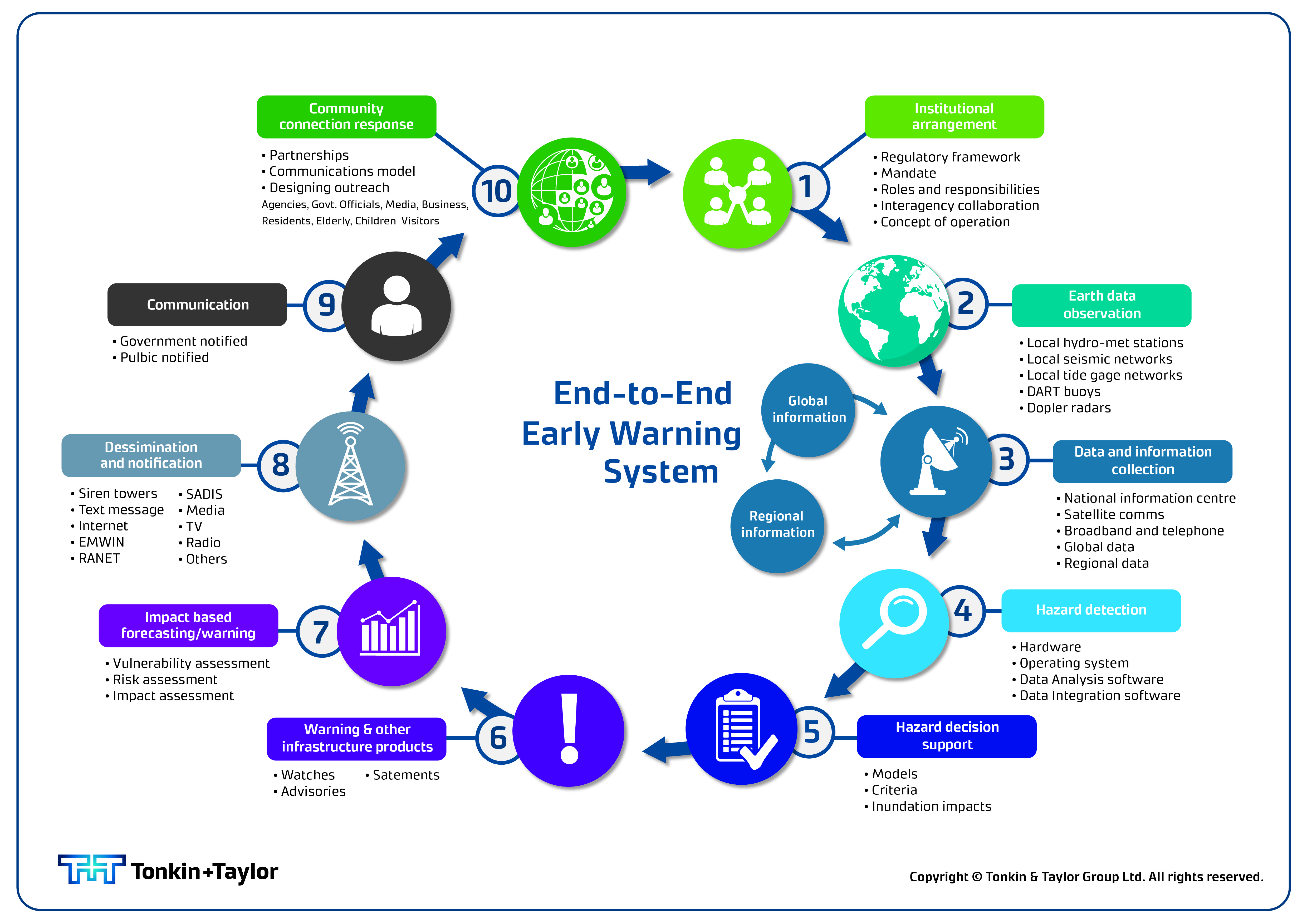
Figure 5: End-to-end impact-based early warning system
Further Reading:
Lorrey, A. M., Griffiths, G., Fauchereau, N., Diamond, H. J., Chappell, P. R. and Renwick, J. (2014), An ex-tropical cyclone climatology for Auckland, New Zealand. Int. J. Climatol., 34: 1157–1168.
S.H.M. Fakhruddin, Akiyuki Kawasaki, Mukand S. Babel, Community responses to flood early warning system: Case study in Kaijuri Union, Bangladesh, International Journal of Disaster Risk Reduction, Volume 14, Part 4, December 2015, Pages 323-331, ISSN 2212-4209, https://doi.org/10.1016/j.ijdrr.2015.08.004.
TCC 16 report of TCWC Wellington. World Meteorological Organization, RA V meeting, Honiara, Solomon Island
Morrow, B. H., and Lazo, 2015: Effective tropical cyclone forecast and warning communication: Recent social science contributions. Tropical Cyclone Research and Review, 4, 38-48
Fakhruddin SHM (2015) Risk Communications for Coastal Inundation Forecasting to the Community. J Psychol Psychother 5:203. doi: 10.4172/2161-0487.1000203 ↑
0 comments