The family of the GR hydrological models – Interview with Charles Perrin and Vazken Andréassian
Contributed by Guillaume Thirel and Maria-Helena Ramos, members of the Irstea Guest Columnist Team
You may have already heard of one of the GR models developed by the Catchment Hydrology research group at Irstea in the Centre of Antony (France). Or you may have already run one of these models in your study catchments or as an exercise with your students.
These models started to be developed in the 80’s, with the support of data from the Orgeval experimental basin, a 104-km² catchment within the River Seine basin, managed by the GIS-ORACLE Group and monitored by Irstea since 1962.
Historically, the development of the models was dependent on the time step, and different lumped, reservoir-based structures were specifically proposed for the simulation of river flows at the hourly, daily, monthly and annual time steps.
Today, a time-independent structure is being developed, and progress has also been made through the incorporation of new modelling components, e.g., snow modelling, model uncertainty quantification and data assimilation for real-time forecasting, etc.. Semi-distributed versions of the GR models were also implemented, as well as dedicated calibration strategies. The main objective of these developments is to robustly model flows at gauged and ungauged catchments (check the team’s publications here).
Claude Michel (who retired in 2007) is the father of these developments, and showed an original path to hydrological modelling in the 1980s. Some of his students, among which are Vazken Andréassian and Charles Perrin (who fortunately are not planning their retirement yet!), tried to follow this direction.
We asked Charles and Vazken some questions about hydrological modelling, the history and future of the GR models, as well their applications to real-time flood forecasting in France:
GT: The most well-known of the GR models is certainly the GR4J model, a model with 4 parameters for the daily time step, which has been applied in several parts of the world and has quite a success in Australia. Why do you think GR4J is so successful in simulating streamflows? What are its main strengths?
CP: Probably this question should be asked to the users themselves! I can see three main aspects that may have encouraged the use of this model in various contexts. Firstly, the model is easy to implement because of its simplicity and parsimony. These two qualities are the result of the development approach adopted by Claude Michel, which prevented to propose overly-complex or overparameterized models. It makes the model very easy to implement.
Secondly, partly because of data availability issues, the daily model was the starting point of the GR model developments, and hence received much attention. Since the daily time step is well adapted for a wide range of practical applications, the daily model was therefore widely tested. Lastly, but not least, the model proved to be quite robust and general enough to be applied in various hydro-climatic contexts, which was also a quality sought during its development. This was shown in various intercomparisons (led, for example, by Australian colleagues among others), which may have increased the confidence of end-users.
However, the term “success” is probably excessive. Feedbacks from end-users have also shown that the “Court of Miracles” of the model remains large [see Andréassian et al., 2010, for a discussion], and that it can obviously not be considered the panacea in all circumstances.
MHR: The GRP model is widely used for real-time flood forecasting in France. Looking back in time, what were the most difficult steps for its implementation in real-time and its use by the operational services?
CP: In the 1990s, there was no actual flood forecasting services in France and the centres in charge of flood monitoring were mostly doing flood warning based on observations and simple propagation methods on main streams. However, several catastrophic events, especially in southern France, stressed the urgent need to develop appropriate forecasting systems based on rainfall to increase anticipation.
The research developed by Claude Michel at that time produced forecasting tools based on the GR models and simple assimilation techniques. From theory to practice, one often says that there is a gap. Developing operational tools based on the GRP model (our flood forecasting model) was some kind of trial-and-error process. The main difficulty was to find a way to develop a system that could (1) meet users’ expectations (in terms of results, easiness-of-use), (2) be flexible enough to evolve with results of research, and (3) be compatible with limited software development means available.
Today, thanks to the work coordinated by Carina Furusho-Percot in our team, the model is quite widely used operationally in France. This gives very interesting feedbacks that show the advantages… but also the limits of the model, which is very useful to identify the most promising paths to improve the model. The next step is probably to widen the use of ensemble forecasts through the GRP model by operational services in France; an activity that in our team is led by you and which should benefit from the large work made by the HEPEX community.
GT: If you could go back in time and start developing a hydrological model again, what would be your first concern or where would you first put the focus of your development on?

Two different ‘models’ of the Spitfire. Which one is the most faithful-looking model? Which one would fly? (source: VA, after Sten Bergström)
CP: Sten Bergström often used this metaphor of the model of the Spitfire, distinguishing the issues of model fidelity and model prediction capacity. Our team has given priority to the prediction capacity, trying to find afterwards links with catchment-scale representation. Other teams may prefer the way round. Probably (or even fortunately) there is no ideal or single path to develop models and both have their advantages and drawbacks. However, as applied modellers, probably starting by seeking models that can “fly” is a nice (and already large) endeavour.
One pleasant feature with the approach we developed at Irstea is that our simple models are white boxes, in which the internal behaviour of the model is probably easier to understand than much more complex models. To go a step forward, there are certainly ways to develop models which will be more efficient because their fidelity is improved. Probably interesting ways to explore in the future!
GT: Vazken, in your opinion, what is a good hydrological model?
VA: This is a tough question. But if I am to answer it shortly, I would start by saying that there certainly is no unique answer. We must recognize that we are now in a world of large model diversity, and the questions really are which hypothesis can we test with which model? and which decision can we base on which model?
I like to draw an analogy between hydrological models and maps. And I believe that there are no ‘good’ maps, there are only maps which are better than others depending on what you would like to to do with it. Sometimes, a map of imaginary places can have a pedagogical interest [see below].
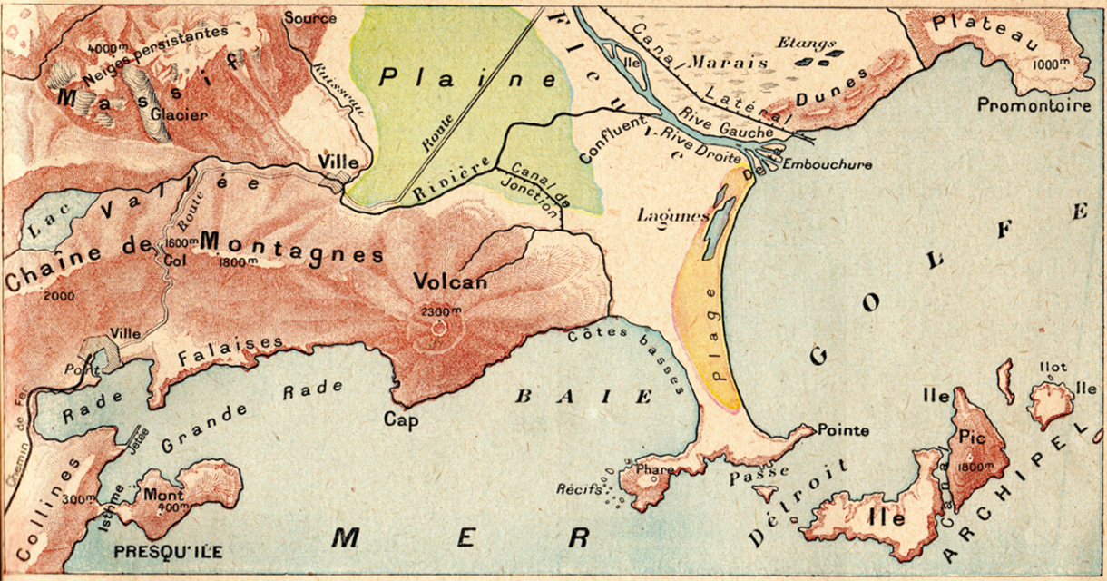
Pedagogical map summarizing geographical features (source: VA, taken from an old manual of geography)
Alike a map, a model represents the reality but it is not the reality: as we often say “the map is not the territory”, I would like to hear modellers acknowledge that the model is not the reality, and, unavoidably, results from a simplification, a conceptualization. For those who like literature, I would recommend reading Lewis Caroll, Borges and Umberto Eco, who all wrote on the absurdity of the 1:1 scale map. We could say similar things on the all-mighty ‘physical’ hydrological model.
Alike the map, the model is wrong. But the map is very useful for the traveller, and the model to the hydrologist. Alike the map, the model is a decision support tool, which can take different shapes depending on the objective of the user.
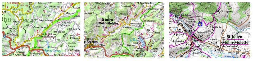
Three different maps but useful at a different level for a traveller wanting to reach the charming city of St Julien-Molin-Molette (source: VA, taken from geoportail IGN, France)
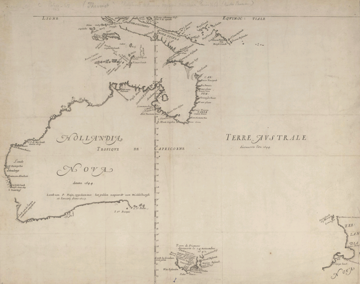
Incomplete Australia by M. Thevenot in 1663 (source: VA)
And the amazing thing with maps and models is that a model can be extremely useful even if it is not exhaustive. See the example of the early map of Australia by M. Thevenot from 1663. It is not exhaustive, it is incomplete… but it was the best that geographers could do at some point in history. We should certainly look at our models in a similar way.
GT: If you were to cite one essential property of the ‘good’ model?
VA: Nowadays, I tend to give more and more importance to the extrapolation capacity of the models. In hydrology, we need to build maps of the future, of a future that we have not seen yet, of extreme events that will be above all those we have observed. For this, I would say that it is essential to evaluate the extrapolation capacity of our models. Faith in the ‘physical’ nature of the equations is not enough. We need objective evaluations, which can take the form of “crash tests”.
MHR: Vazken, we all know that one of your hobbies is collecting hydrological poems. Have you ever run into a poem dedicated to hydrological modelling?
VA: Hm… there are many interesting hydrologic poems on floods and droughts (see here some of the poems I collected), but I have never run into a poem dedicated to hydrologic modelling. It is however not an impossible task, after all James Maxwell himself did put his own equations into verses (just google for A problem in dynamics), and more recently Tom Pagano wrote a poem on flow forecasting (see Tom’s blog or look here). Jean-Claude Olivry wrote a very interesting poem on African hydrology and on hydrological processes in general (here), and Woody Guthrie wrote countless songs on the Grand Coulee Dam. Nothing specific to modelling, but hundreds of poems on hydrological phenomena.
Thank you, Charles and Vazken, for your time and insights!
![]() For more info:
For more info:
- A brief history of the GR models can be found here.
- If you are interested in using the GR models, you can download the airGR R-package recently developed by our research team. It allows the calibration and run of several models, from the hourly to the annual time step. All information can be found here.
Acknowledgements: This is Irstea’s last contribution as guest columnist team to the HEPEX blog for 2016. We enjoyed a lot this opportunity to communicate and share our viewpoints and we hope you all have also enjoyed reading our posts.
December 7, 2016 at 21:20
Thanks I really enjoyed this, especially the plane analogy!
February 13, 2017 at 01:15
I expect someone to rise to your challenge of writing a poem about hydrologic modeling.