Improving forecasting of flooding from intense rainfall through interdisciplinary research
Contributed by Dr Linda Speight, University of Reading.
In England and Wales alone 3 million properties are at risk of surface water flooding. Having spent the past year speaking to a number of experts in the field (see below), I feel confident saying the universal biggest challenge facing everyone involved in forecasting flooding from intense rainfall is communicating the uncertainties around the location and timing of flood events. Whether you are a researcher looking at developing novel ways to visualise this uncertainty, or an end user trying to make a decision based on the forecast, everyone has to deal with this problem. Delivering effective flood warnings requires a shared understanding of this challenge from a meteorological, hydrological and decision-maker perspective. That requires working together.
The Flooding from Intense Rainfall Programme
Over the past five years the joint NERC (UK Natural Environment Research Council) and UK Met Office funded Flooding from Intense Rainfall Programme (FFIR) has been working to improve the identification, characterisation and prediction of surface water and flash floods in the UK. Designed to explicitly link hydrologists and meteorologists, and with a strong end-user focus, the programme includes academics from multiple universities alongside consultants and operational experts. Each stage of the forecasting chain is considered from observations through to meteorological and hydrological models to support flood warnings and risk communication. The research methods used are diverse, ranging from analysis of historic newspaper archives to drones and computer modelling. Outputs include:
- New methodologies, tools and datasets [1,2] to identify places susceptible to flash flooding (Figure 1).
- Improved weather forecasts for intense rainfall through improvements to radar-rainfall methods, data assimilation [3,4] and better understanding of probabilistic forecasts [5] (Figure 3).
- New techniques for monitoring rivers during flood events [7,8] (Figure 2).
- Demonstration of the potential for real time simulation of floods in urban areas and catchments [9,10] (Figure 4).
You can read a short summary of the scientific outputs here (including a publications list), or watch a video about the programme here.
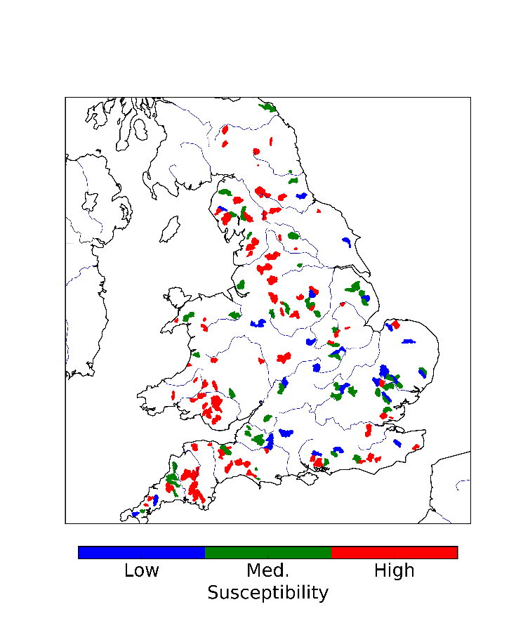
Figure 1. Location of catchments identified as susceptible to flash flooding. Map produced by Greg O’Donnell, Newcastle University.
You can explore the data behind this map here.
Policy and practice review
I had the task of carrying out a policy and practice review of the programme. I spoke to 45 experts including the different research teams around the country as well as the consultancy firms, forecasters and end users represented on the project advisory board. It was really interesting to sit down and talk to people one-to-one about their experiences. While there are many things I could draw out, the recurring theme was the lessons learnt from working in an interdisciplinary programme.
Tips for interdisciplinary working
The acknowledgement of the need for interdisciplinary working in flood forecasting is not new. It was one of the key recommendations to come out of the Pitt review following the 2007 floods in the UK. While the development of the Flood Forecasting Centre in the UK (and other forecasting centres around the world) has led to improved operational relationships, there is still a long way to go in research. Indeed over ten years after the Pitt review, I read a new paper last week again calling for improved integration between researchers and end users to solve the climate and water challenges of the 21st century. The FFIR programme has provided a valuable opportunity to learn how to do this in practice.
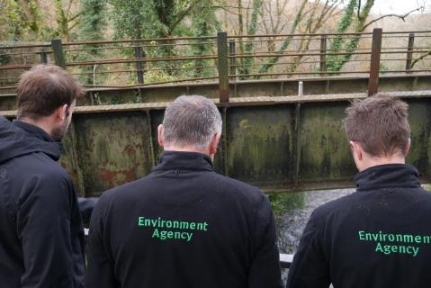
Figure 2. Matt Perks (Newcastle University) working with the Environment Agency to install CCTV cameras to observe floods. Photograph from Nick Everard, Environment Agency
Based on the review, these are my top five recommendations:
- Be prepared to learn a ‘new language’ – you might be using the same words but don’t assume they mean the same thing to everyone.
- Make time for integration – of data, of models, of working practices… they all take longer than envisaged but are rewarding in the end.
- Manage your (and everyone else’s) expectations – academic research is very different to consultancy-led projects.
- Design projects that encourage joint working from the beginning.
- Demonstrate the operational impact of new science – clear evidence of how new research would improve decision making is essential for end users.
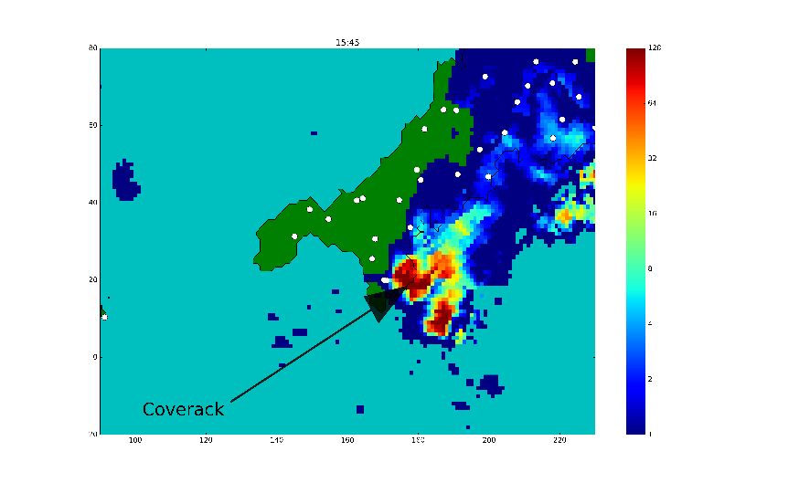
Figure 3. Radar observations of rainfall leading to the July 2017 event in Coverack. Rain gauge locations are shown in white illustrating the importance of defining whether you are talking about rain gauge rainfall totals or radar rainfall. The rain gauge largely missed this major event. Image produced by Rob Thompson, University of Reading.
Bringing it all together
The final stage of the FFIR programme was to bring all the different components of the forecasting chain together to demonstrate how to improve integration in an end-to-end forecasting framework.
My review interviews showed end-to-end forecasting is widely valued across the community. It focuses research on the end goal of issuing effective flood forecasts and warnings through an integrated and interdisciplinary approach. However, we are still a long way from a universal agreement of what an end-to-end forecasting framework for intense rainfall should look like. What information is needed by end-users to make decisions? How do we effectively link meteorology, hydrology, flood inundation and impacts? And importantly, how do we know where in the chain our research will lead to the biggest improvements in decision making? To answer these questions we all need to get much better at joint working.
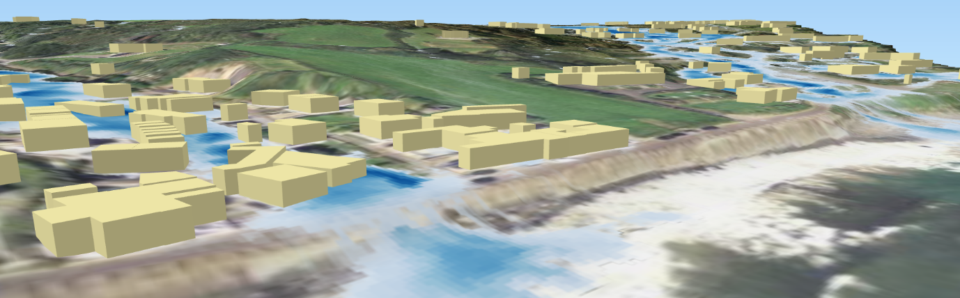
Figure 4. 3D visualisation of modelled flash flooding in Coverack for the July 2017 event. Image produced by Albert Chen, University of Exeter.
A similar version of this article is also posted on the University of Reading Weather and Climate blog.
References
[1] Archer, D.R., and H.J. Fowler (2015), “Characterising flash flood response to intense rainfall and impacts using historical information and gauged data in Britain.” Journal of Flood Risk Management 11(S1): S121–S133 https://doi.org/10.1111/jfr3.12187
[2] Blenkinsop, S., E. Lewis, S. C. Chan and H. J. Fowler (2017). “Quality-control of an hourly rainfall dataset and climatology of extremes for the UK.” International Journal of Climatology 37(2): 722–740. https://doi.org/10.1002/joc.4735
[3] Waller, J., S. Ballard, S. Dance, G. Kelly, N. Nichols and D. Simonin (2016). “Diagnosing Horizontal and Inter-Channel Observation Error Correlations for SEVIRI Observations Using Observation-Minus-Background and Observation-Minus-Analysis Statistics.” Remote Sensing 8(7): 581. https://doi.org/10.3390/rs8070581
[4] Waller, J. A., D. Simonin, S. L. Dance, N. K. Nichols and S. P. Ballard (2017). “Diagnosing Observation Error Correlations for Doppler Radar Radial Winds in the Met Office UKV Model Using Observation-Minus-Background and Observation-Minus-Analysis Statistics.” Monthly Weather Review 144(10): 3533–3551. https://doi.org/10.1175/MWR-D-15-0340.1
[5] Flack, D. L. A., R. S. Plant, S. L. Gray, H. W. Lean, C. Keil and G. C. Craig (2016). “Characterisation of convective regimes over the British Isles.” Quarterly Journal of the Royal Meteorological Society 142(696): 1541–1553. https://doi.org/10.1002/qj.2758
[6] Flack, D. L. A., S. L. Gray, R. S. Plant, H. W. Lean and G. C. Craig (2018). “Convective-Scale Perturbation Growth across the Spectrum of Convective Regimes.” Monthly Weather Review 146(1): 387–405. https://doi.org/10.1175/MWR-D-17-0024.1
[7] Perks, M. T., A. J. Russell and A. R. G. Large (2016). “Technical Note: Advances in flash flood monitoring using unmanned aerial vehicles (UAVs).” Hydrology and Earth System Sciences 20: 4005–4015. https://doi.org/10.5194/hess-20-4005-2016
[8] Starkey, E., G. Parkin, S. Birkinshaw, A. Large, P. Quinn and C. Gibson (2017). “Demonstrating the value of community-based (‘citizen science’) observations for catchment modelling and characterisation.” Journal of Hydrology 548: 801–817. https://doi.org/10.1016/j.jhydrol.2017.03.019
[9] Chang, T.-J., C.-H. Wang, A. S. Chen and S. Djordjević (2018). “The effect of inclusion of inlets in dual drainage modelling.” Journal of Hydrology 559: 541–555. https://doi.org/10.1016/j.jhydrol.2018.01.066
[10] Liang, Q., X. Xia and J. Hou (2016). “Catchment-scale High-resolution Flash Flood Simulation Using the GPU-based Technology.” Procedia Engineering 154: 975–981. https://doi.org/10.1016/j.proeng.2016.07.585
0 comments