22 Years and Still Flooding
by Andrea Holz, a HEPEX 2015 Guest Columnist
Andrea is an operational forecaster at the US National Weather Service’s North Central River Forecast Centre. She writes about some very specific forecasting challenges that she and her colleagues are faced with on a daily basis.
Devils Lake is the most fascinating, expensive and devastating piece of hydrology out of the 900,000 square kilometer drainage area under the responsibility of the US NWS North Central River Forecast Center. High lake levels are part of the natural weather cycle. This is not without problems however, and the lake comes with some very specific forecasting challenges.
The hydrology
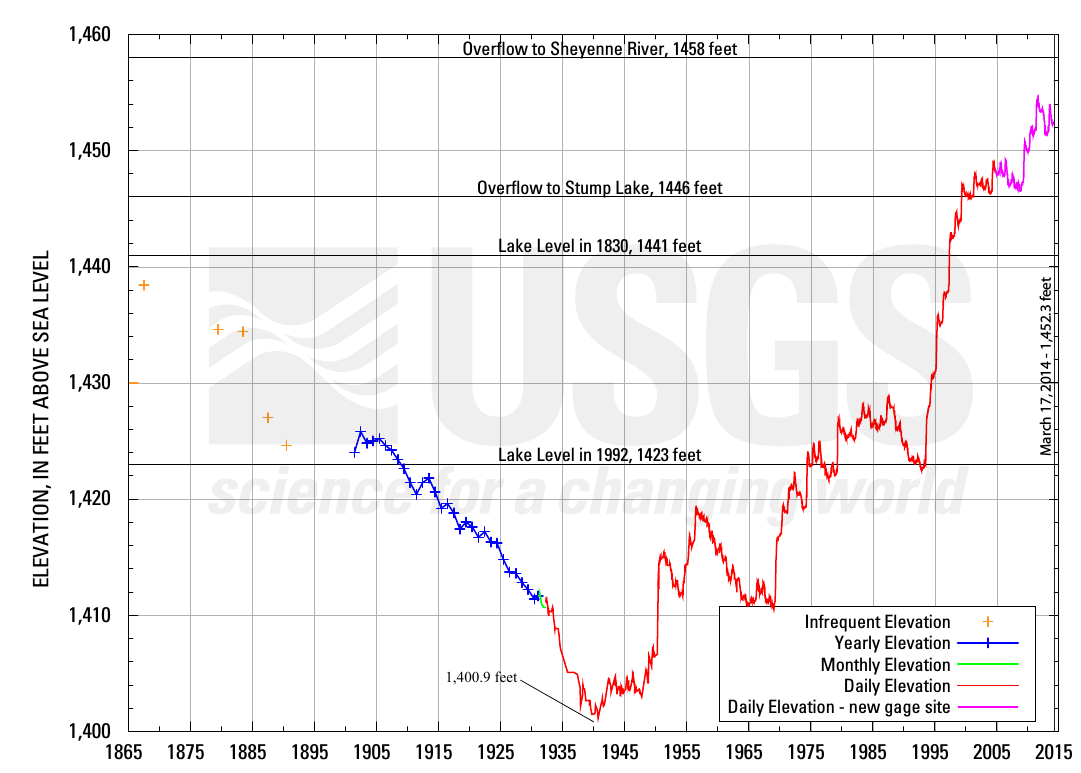
Derived from the Lakota name Ble Waka Sica or “Lake of the Spirits,” Devils Lake, in North Dakota, is a closed basin of about 9800 square kilometers, and the lake water is high in salinity. At the time of statehood (1889), the elevation of the surface of the Tolna Coulee (the natural outlet) was one foot lower than its 1997 elevation of 1459 (feet above MSL). This determination by the North Dakota Geological Survey was based on the depth of Russian thistle pollen – brought by settlers – in the soil. Additional analyses showed that Devils Lake has fluctuated by 20 meters 4-5 times over the past 4000 years. Geologists estimate that Devils Lake has reached elevation 1458 at least twice during the past 4000 years, the last time less than 2000 years ago. The United States Geological Survey (USGS) lake elevation gage began recording in 1930.
The problem
Climate variability has caused the lake to rise almost 10 meters over the past 22 years, with a recorded peak in June 2011 at elevation 1454.3+MSL. Since 1993 the surface area of the lake has increased over 676 square kilometers, directly affecting approximately 15,000 people. Over 600 homes have been relocated or destroyed and over 280 square kilometers of farmland is currently underwater. Hundreds of millions of dollars have already been spent in keeping highways and railroads open. Plow trucks run year-round, pushing debris left by 2-3 meter high waves off the roadways. Twenty-three people have died by driving off roads since 1994. The estimated economic loss in the region due to high lake levels is near $200 million annually. The state of North Dakota along with the U.S. Federal Government have spent over one billion dollars on flood protection to date. The first embankment – built in 1984 to protect the City of Devils Lake – has been raised four times since 1996 and is now called a dam. In 2005, rising lake levels required the USGS gage to be moved.
-
- Devils Lake elevation over the past 150 years.
-
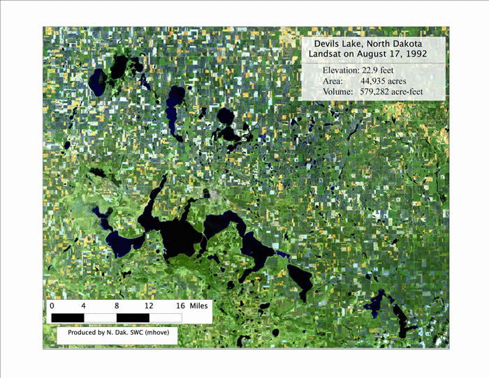
- A set of Landsat satellite images, showing the development of the lake surface from 1992 to 2009.
The intervention
Devils Lake connects with Stump Lake, located just Southeast, via the Jerusalem Channel. The two lakes started to merge in 1999 and Stump Lake has risen over 14 meters since. Overflow from Stump Lake into the Sheyenne River naturally occurs through the Tolna Coulee – located on the west side of Stump Lake – at elevation 1458+MSL. Due to highly erodible soils, natural uncontrolled overflow at Tolna Coulee has the potential to scour the downstream channel, causing upwards of 40% of the lake volume to be released. This relatively quick release of water could cause significant problems downstream. In 2012, the U.S. Army Corps of Engineers completed construction on a control structure at Tolna Coulee to prevent an uncontrolled overflow. The control structure is designed to limit releases to 85 cubic meters per second (cms).
Two outlets with operating pumps were constructed by the State of North Dakota since 2005 and the current maximum pumping capacity is 17 cms. North Dakota winters are long and bitter, so the pumps are typically operated during the warmer months June through early November. These outlets were controversial from the start due to water quality issues downstream. Water from Devils Lake is pumped into the Sheyenne River, a tributary to the Red River, which is the border of North Dakota and Minnesota, and flows north into Lake Winnipeg in Canada. The Sheyenne River has a channel capacity estimated to be 17 cms.
In the fall of 2013, more than half of the total flow in the Red River at Halstad was from water being pumped out of Devils Lake. 2013 also saw the 4th highest inflow volume into Devils Lake since 1992.
The forecasts
Historically, the National Weather Service (NWS) provided two forecast lake elevations in January for a typical July peak: one with “normal” precipitation and one with no precipitation. Since the Devils Lake Basin was receiving anything but “normal” precipitation, the NWS began issuing monthly probabilistic forecasts – using some 60 years of climate data – in January of 2001. These long range hydrologic “outlooks” with a January through September forecast window take the form of exceedance and non-exceedance curves. The products are heavily coordinated with the U.S. Army Corps of Engineers, North Dakota State Water Commission, and the USGS before they are finalized and sent to the public website. This website is consulted by various end user groups, including agricultural producers, land owners, and communities that are in the process of being relocated.
-
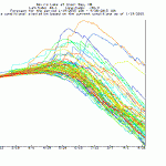
- The current forecast showing the ~70 traces.
-
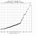
- The current forecast showing exceedance probabilities
The future lake levels are highly uncertain, not in the least because of the sparsity and scarcity of real-time observers; there are two only in the entire basin. This results in a large spread in the ensemble traces (Fig X). Since it has been difficult to convey how to use the uncertainty inherent in probabilistic forecasts, the end users are challenged on how to use the probabilistic outlooks in their personal decision making and the NWS receives frequent requests for “one number”.
The forecasts rest heavily on the assumption of a constant pumping discharge of 17 cms from June through early November. This assumption is often challenged due to high natural flows in the Sheyenne River which necessitate reduced pumping, or mechanical problems with the pumps themselves.
Devils Lake is currently frozen and at elevation 1451.56 MSL. The basin has been very dry since September, and less than 2 centimeters of water is contained in the current snowpack. The probabilistic forecast issued by the NWS on January 23rd shows only a 10% chance of the lake rising one foot.
Additional reading
North Dakota State Water Commission – Devils Lake Flooding
United States Geological Survey – Devils Lake Basin
National Weather Service – Devils Lake Forecasts
Devils Lake Basin Joint Water Resource Board
American Scientist – Runaway Devils Lake
Andrea Holz is a HEPEX 2015 Guest Columnist.
February 1, 2015 at 11:11
Thanks Andrea for this very nice and clear post. When you say that ‘the NWS receives frequent requests for “one number”’ that reminds me the last post of Massimiliano where a similar issue was pointed out, when he says that end-users were happy with the probabilistic system, but still asking for the “right” member. We have similar issues in France too (operational forecasters do want scenarios for the future, but not too many!).
I am asking myself: what are we missing here? How can we (if we can) contribute to assessing this issue? Is this our (as hydrologists/meteorologists) job? How should we contribute to connect the development of probabilistic systems to risk-based decision-making methods?
Liz Stephens once called our attention to engage more with social sciences (see her post here) She also asked an interesting question (see here): “But what sort of information from end-users can be fed back into the science?”
I think we have here some important issues for multi-disciplinary research. Sharing experiences in Hepex may certainly help us, since the community has researchers but also end-users involved in its activities.
Does anybody have an experience or an opinion to share here with us?
February 6, 2015 at 01:32
Nice posting! The Devil’s Lake flooding case is a vexing one for hydrologist because it provides a clear example of where assumptions of stationarity embedded in traditional forecasting (for seasonal and longer outlooks) fail to adequately convey risks to decisionmakers. A bit over 15 years ago, before DL had overflowed into Stump Lake, USACE was assessing whether it made economic sense to build the pumps, among other mitigation options. For a town of little over 7000 people (don’t do the math on the $1B), any option was relatively expensive, especially given funds already spent building levees, relocations and moves.
I was at the USACE Institute for Water Resources at the time, and was tasked to build a small model of the lake system in Stella to help decisionmakers and stakeholders visualize scenarios of future lake rise going out 5 years. These were generated by a USGS statistical model trained on past lake inflow series, if I recall correctly. Each year for several years prior, the inflow projection model was updated…and each year, Devil’s Lake again rose to levels that projections had assigned only very small probability. The credibility of the USGS model, after sequential years of ‘chasing the rise’, had begun to erode. A number of experts on statistical hydrology were also consulted, including Nick Matalas, Jim Wallis and Manu Lall (who had made 5-year statistical projections for the Great Salt Lake), and interesting theories about the near monotonic rise were put forth (ie a systemic change in the position of the low level jet? drainage practices?).
Then, as now, we still don’t fully understand the drivers of the low frequency hydroclimate variability that is particularly evident in closed basin lakes like this one. We fall back on historical hydroclimate statistics (such as are contained in the NWS ESP-based outlooks) in the absence of greater insights, and on the whole, such forecasting challenges remain compelling, but also sobering.